
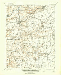
1917 Map of Xenia
USGS Topo · Published 1934About this map
Xenia serves as the bustling regional hub of this Greene County landscape, where the confluence of major rail lines like the Pittsburgh Cincinnati Chicago and St Louis RR and the Springfield and Little Miami RR dictated the pace of commerce during the early twentieth century. The map reveals a high density of public institutions and educational sites, most notably Wilberforce University and the extensive Soldiers and Sailors Orphans Home on the city's outskirts.
Find a feature on this map
111 named features on this map. Tap any name to fly to it.
Don’t see what you’re looking for? This feature index may not catch every label — zoom into the map to look around manually.
Map Details
Editions of this 1917 Xenia Map
2 editions found
Other maps of this area

1904 · Springfield
USGS Topo · 1:62,500

1904 · Dayton
USGS Topo · 1:62,500

1906 · Dayton
USGS Topo · 1:62,500

1906 · Springfield
USGS Topo · 1:62,500

1907 · Blanchester
USGS Topo · 1:62,500

1907 · South Charleston
USGS Topo · 1:62,500

1913 · Waynesville
USGS Topo · 1:62,500

1914 · Morrow
USGS Topo · 1:62,500

1915 · Waynesville
USGS Topo · 1:62,500

1916 · Morrow
USGS Topo · 1:62,500
Featured Places
- Xenia, OH
- Cedarville, Cedarville Township
- New Jasper, New Jasper Township
- Jamestown, Silvercreek Township
- Harveysburg, OH