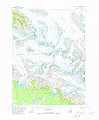
1959 Map of Yakutat B-2
USGS Topo · Published 1975About this map
Brabazon Range dominates the interior of this topographic study, where massive ice fields and sharp peaks define the landscape of the Tongass National Forest. Derived from 1948 aerial photography and field-annotated in 1959, the map captures a glacial system in transition, featuring the expansive Novatak Glacier and Chamberlain Glacier. An Indefinite Boundary meanders through the high ridges, signifying the challenges of surveying such inaccessible terrain. In the lower elevations to the southwest, the Ustay River and Tanis River emerge from glacial melt, feeding into Ustay Lake and Tanis Lake. Human presence is minimal, marked only by a solitary Landing Strip near the confluence of Glines Creek, providing a vital link to this wilderness during the mid-twentieth century.
Find a feature on this map
19 named features on this map. Tap any name to fly to it.
Don’t see what you’re looking for? This feature index may not catch every label — zoom into the map to look around manually.
Map Details
Editions of this 1959 Yakutat B-2 Map
3 editions found
Other maps of this area

1951 · Yakutat
USGS Topo · 1:250,000

1959 · Yakutat A-1
USGS Topo · 1:63,360

1959 · Yakutat C-3
USGS Topo · 1:63,360

1959 · Yakutat A-2
USGS Topo · 1:63,360
1959 · Yakutat A-3
USGS Topo · 1:63,360

1959 · Yakutat B-3
USGS Topo · 1:63,360

1959 · Yakutat B-2
USGS Topo · 1:63,360

1959 · Yakutat B-1
USGS Topo · 1:63,360

1959 · Yakutat
USGS Topo · 1:250,000
1985 · Yakutat C-1
USGS Topo · 1:63,360