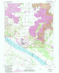
1964 Map of Yankeetown
USGS Topo · Published 1984About this map
Yankeetown and the surrounding riverfront of Warrick County define this landscape along the Ohio River in the early 1980s. The region is marked by a complex industrial and rural transition, where extensive Strip Mine operations dominate the northern and eastern uplands, reshaping the terrain near Pelzer and Red Bush. Along the riverbanks, navigation infrastructure like the Newburgh Locks and Dam sits near Scuffletown, while older river settlements such as Vanada and Carlinburg remain across the state line. Genealogists will find several notable burial sites and rural institutions, including Hedges Cem and Bates Hill Cem, alongside country congregations like St Ruperts Ch and Pleasant Chapel. The Southern railroad line cuts through the center of the sheet, serving the coal and industrial interests that border the meandering path of Little Pigeon Creek.
Find a feature on this map
51 named features on this map. Tap any name to fly to it.
Don’t see what you’re looking for? This feature index may not catch every label — zoom into the map to look around manually.
Map Details
Editions of this 1964 Yankeetown Map
4 editions found
Other maps of this area

1900 · De Gonia Springs
USGS Topo · 1:62,500

1901 · Owensboro
USGS Topo · 1:62,500

1902 · Ditney
USGS Topo · 1:125,000

1902 · Degonia Springs
USGS Topo · 1:62,500

1902 · Boonville
USGS Topo · 1:62,500

1905 · Newburg
USGS Topo · 1:62,500

1951 · Yankeetown
USGS Topo · 1:24,000

1951 · Spottsville
USGS Topo · 1:24,000

1952 · Owensboro West
USGS Topo · 1:24,000

1952 · Newburgh
USGS Topo · 1:24,000