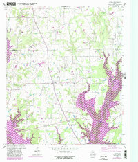
1959 Map of Yantis
USGS Topo · Published 1987About this map
Yantis and its surrounding rural communities are captured here during a period of transition as the landscape prepared for the expansion of the Lake Fork Reservoir. The map illustrates a wood-and-pasture environment defined by small settlements like Seymore and Gamblin, alongside a network of country churches including White Oak Ch and County Line Ch. The industrial footprint of the region is prominent, with the Yantis Gas and Oil Field and Como Oil Field marking the landscape with various gas wells and pipelines. Of particular note for local historians are the numerous cemeteries and the Sandifer Sch, which provide evidence of the area's established social fabric before later 20th-century developments altered the local geography. The survey effectively documents the intersection of rural agriculture and the burgeoning energy sector along the Hopkins and Wood County line.
Find a feature on this map
34 named features on this map. Tap any name to fly to it.
Don’t see what you’re looking for? This feature index may not catch every label — zoom into the map to look around manually.
Map Details
Editions of this 1959 Yantis Map
3 editions found
Other maps of this area

1953 · Texarkana
USGS Topo · 1:250,000

1956 · Texarkana
USGS Topo · 1:250,000

1956 · Tyler
USGS Topo · 1:250,000

1958 · Arbala
USGS Topo · 1:24,000

1958 · Alba
USGS Topo · 1:24,000

1959 · Calvary
USGS Topo · 1:24,000

1959 · Yantis
USGS Topo · 1:24,000

1959 · Alba
USGS Topo · 1:62,500

1960 · Pleasant Grove
USGS Topo · 1:24,000

1960 · Quitman
USGS Topo · 1:24,000