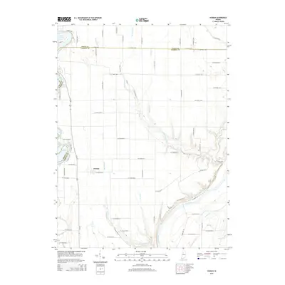
2014 Map of Yeoman
USGS Topo · Published 2014About this map
The town of Yeoman serves as a central landmark in this portion of Indiana, where the landscape is defined by the transition between managed agricultural drainage and significant natural waterways. The southern boundary is dominated by the Wabash River, which is joined by local tributaries such as Mitchell Cr and Pleasant Run. To the northwest, the map captures the southern reaches of Lake Freeman, a major reservoir formed on the Tippecanoe River. The intricate drainage network, including Beck Ward Ditch and Hardy Ditch, illustrates the intensive land management required for the region's farming economy. Local history is etched into the terrain through features like Tannery Br and Squaw Br, while a dense grid of county roads, including W Co Road 1300 N and N Us-421, provides the infrastructure for this rural community spanning the White and Carroll county line.
Find a feature on this map
60 named features on this map. Tap any name to fly to it.
Don’t see what you’re looking for? This feature index may not catch every label — zoom into the map to look around manually.
Map Details
Editions of this 2014 Yeoman Map
This is the sole edition of this map. No revisions or reprints were ever made.
Other maps of this area

1953 · Danville
USGS Topo · 1:250,000

1955 · Danville
USGS Topo · 1:250,000

1956 · Danville
USGS Topo · 1:250,000

1962 · Flora
USGS Topo · 1:24,000

1962 · Burrows
USGS Topo · 1:24,000

1962 · Monticello South
USGS Topo · 1:24,000

1962 · Delphi
USGS Topo · 1:24,000

1962 · Burnettsville
USGS Topo · 1:24,000

1962 · Monticello North
USGS Topo · 1:24,000
1962 · Yeoman
USGS Topo · 1:24,000