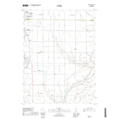
2019 Map of Yeoman
USGS Topo · Published 2019About this map
Monticello sits at the northern edge of this White and Carroll County landscape, where the waters of Lake Freeman meet the residential developments of Terrace Bay and Upper Sunset Park. The map documents a predominantly agricultural interior defined by the straight lines of rural roads like Co Rd 1300 N and the natural meanders of Rattlesnake Creek. To the south, the terrain descends toward the Wabash River, which forms a winding boundary near Sleeth. This area is particularly detailed for genealogical research, showing numerous local burial grounds including Yeoman Cem, Schock Cem, and the Riverview Cem overlooking the river. The small settlement of Yeoman serves as a central hub, illustrating the enduring layout of rural Indiana hamlets in the early 21st century. The map also reveals how modern drainage systems like Beck Ward Ditch and Hardy Ditch have been integrated into the natural hydrology of Pleasant Run and Tannery Br.
Find a feature on this map
61 named features on this map. Tap any name to fly to it.
Don’t see what you’re looking for? This feature index may not catch every label — zoom into the map to look around manually.
Map Details
Editions of this 2019 Yeoman Map
This is the sole edition of this map. No revisions or reprints were ever made.
Other maps of this area

1953 · Danville
USGS Topo · 1:250,000

1955 · Danville
USGS Topo · 1:250,000

1956 · Danville
USGS Topo · 1:250,000

1962 · Flora
USGS Topo · 1:24,000

1962 · Burrows
USGS Topo · 1:24,000

1962 · Monticello South
USGS Topo · 1:24,000

1962 · Delphi
USGS Topo · 1:24,000

1962 · Burnettsville
USGS Topo · 1:24,000

1962 · Monticello North
USGS Topo · 1:24,000
1962 · Yeoman
USGS Topo · 1:24,000