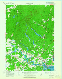
1956 Map of York Harbor
USGS Topo · Published 1965About this map
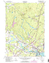
York Village and its neighboring coastal settlements are captured here during a period of transition in the mid-1950s. The map illustrates a landscape where colonial heritage and modern infrastructure intersect, featuring the historic Old Gaol and the First Parish Church alongside the newer Maine Turnpike and Toll Road. This era shows the developed shoreline at York Harbor and York Beach while the interior remains defined by extensive woods and marshes. Notable local landmarks like the Machtire Garrison and the York Utilities Railroad route provide deep historical context for genealogists and local historians. The terrain rises sharply from the tidal York River to prominent heights such as Mt Agamenticus and Second Hill, which dominate the northern forest lands. Small inland communities like Agamenticus Village, Scotland, and Cider Hill appear as modest clusters of buildings, reflecting the traditional rural settlement patterns that predated the rapid expansion of coastal tourism.
Find a feature on this map
101 named features on this map. Tap any name to fly to it.
Don’t see what you’re looking for? This feature index may not catch every label — zoom into the map to look around manually.
Map Details
Editions of this 1956 York Harbor Map
5 editions found
Other maps of this area

1891 · Berwick
USGS Topo · 1:62,500

1891 · Kennebunk
USGS Topo · 1:62,500

1893 · Kennebunk
USGS Topo · 1:62,500

1893 · Dover
USGS Topo · 1:62,500

1893 · Berwick
USGS Topo · 1:62,500

1893 · York
USGS Topo · 1:62,500

1898 · Kennebunk
USGS Topo · 1:62,500

1916 · Dover
USGS Topo · 1:62,500

1918 · Dover
USGS Topo · 1:62,500

1920 · York
USGS Topo · 1:62,500