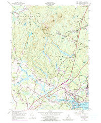
1956 Map of York Harbor
USGS Topo · Published 1990About this map
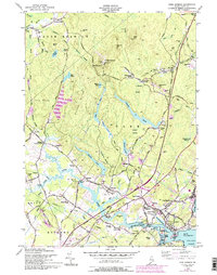
Mt Agamenticus anchors the northern high ground of this coastal landscape, looking down over a complex network of ponds and marshes that feed the York River. Near the coast, the historical core of the region is centered around York Village, where the First Parish Church and First Parish Cemetery mark centuries of local settlement. Further inland, the map captures a transition from rural crossroads like Brixham Lower Corners and Scotland to the developing infrastructure of the mid-20th century. The arrival of the modern era is marked by the prominent path of the Maine Turnpike, which bypasses the older colonial-era routes. Notable local features like York Harbor and York Heights show a landscape balancing its maritime heritage with residential growth, while the Old Railroad Grade near Beech Ridge hints at earlier transportation networks that once linked these shore communities.
Find a feature on this map
104 named features on this map. Tap any name to fly to it.
Don’t see what you’re looking for? This feature index may not catch every label — zoom into the map to look around manually.
Map Details
Editions of this 1956 York Harbor Map
5 editions found
Other maps of this area

1891 · Berwick
USGS Topo · 1:62,500

1891 · Kennebunk
USGS Topo · 1:62,500

1893 · Kennebunk
USGS Topo · 1:62,500

1893 · Dover
USGS Topo · 1:62,500

1893 · Berwick
USGS Topo · 1:62,500

1893 · York
USGS Topo · 1:62,500

1898 · Kennebunk
USGS Topo · 1:62,500

1916 · Dover
USGS Topo · 1:62,500

1918 · Dover
USGS Topo · 1:62,500

1920 · York
USGS Topo · 1:62,500