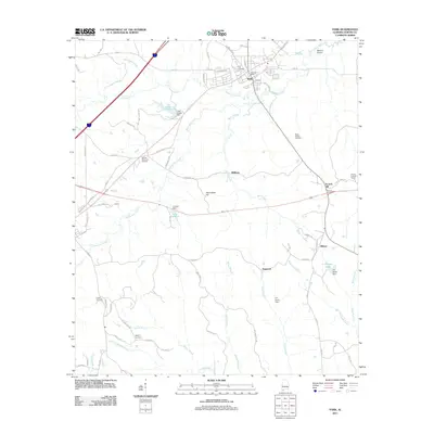
2011 Map of York
USGS Topo · Published 2011About this map
York serves as the primary hub in this early 21st-century portrait of western Sumter County, where the York Post Office and Mallard Airport anchor the local infrastructure. The landscape is defined by the winding paths of Alamuchee Creek and Toomsuba Creek, which flow through a region characterized by small-scale impoundments like Lake Louise and Lake Carolyn. Significant for genealogical research, the map identifies numerous burial grounds scattered across the countryside, including York Cemetery, Rocks Chapel Cemetery, and the more remote Woods Cemetery near Scratch Hill.
Find a feature on this map
77 named features on this map. Tap any name to fly to it.
Don’t see what you’re looking for? This feature index may not catch every label — zoom into the map to look around manually.
Map Details
Editions of this 2011 York Map
This is the sole edition of this map. No revisions or reprints were ever made.
Other maps of this area

1929 · Epes
USGS Topo · 1:48,000

1932 · Epes
USGS Topo · 1:62,500

1953 · Meridian
USGS Topo · 1:250,000

1957 · Meridian
USGS Topo · 1:250,000

1965 · Meridian
USGS Topo · 1:250,000

1971 · Gaston
USGS Topo · 1:24,000

1971 · Bellamy
USGS Topo · 1:24,000

1974 · Boyd
USGS Topo · 1:24,000

1974 · Ward
USGS Topo · 1:24,000
1974 · Tamola
USGS Topo · 1:24,000