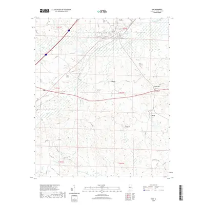
2020 Map of York
USGS Topo · Published 2020About this map
York serves as a central hub in this western Alabama landscape, where the confluence of several small settlements and rural cemeteries marks the local heritage. To the southwest, Cuba sits near the winding course of Toomsuba Cr, while other small locales like Williams, Standard, and Siloam are scattered across the terrain. Family and community history is preserved in sites such as Home Mission Cem, Woods Cem, and McElroy Cem. The topography is defined by the drainage of Alamuchee Creek and its many tributaries, including Brockway Cr and Little Kinterbish Creek. Rising above the creek bottoms are modest elevations like Alamuchee Hill and Scratch Hill. This modern survey documents the road network connecting these points, from established routes like Old Livingston Rd and Old US Hwy 11 to smaller local passages like Behn Kidd Rd.
Find a feature on this map
90 named features on this map. Tap any name to fly to it.
Don’t see what you’re looking for? This feature index may not catch every label — zoom into the map to look around manually.
Map Details
Editions of this 2020 York Map
This is the sole edition of this map. No revisions or reprints were ever made.
Other maps of this area

1929 · Epes
USGS Topo · 1:48,000

1932 · Epes
USGS Topo · 1:62,500

1953 · Meridian
USGS Topo · 1:250,000

1957 · Meridian
USGS Topo · 1:250,000

1965 · Meridian
USGS Topo · 1:250,000

1971 · Gaston
USGS Topo · 1:24,000

1971 · Bellamy
USGS Topo · 1:24,000

1974 · Boyd
USGS Topo · 1:24,000

1974 · Ward
USGS Topo · 1:24,000
1974 · Tamola
USGS Topo · 1:24,000