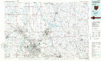
1986 Map of Youngstown
USGS Topo · Published 1988About this map
Industrial and educational centers dominate this mid-1980s look at the Ohio-Pennsylvania border, where the Mahoning River corridor links Youngstown, Warren, and Niles. The region's transition from heavy industry is reflected in a landscape where massive rail networks like Conrail and the Baltimore and Ohio serve the river valleys while sprawling nature preserves and water management projects define the outskirts. Major academic institutions including Youngstown State Univ and Slippery Rock Univ anchor the urban and collegiate settlements of the two states.
Find a feature on this map
339 named features on this map. Tap any name to fly to it.
Don’t see what you’re looking for? This feature index may not catch every label — zoom into the map to look around manually.
Map Details
Editions of this 1986 Youngstown Map
2 editions found
Other maps of this area

1902 · New Castle
USGS Topo · 1:62,500

1904 · Newcastle
USGS Topo · 1:62,500

1904 · Chardon
USGS Topo · 1:62,500

1905 · Andover
USGS Topo · 1:48,000

1905 · Bristolville
USGS Topo · 1:62,500

1905 · Garrettsville
USGS Topo · 1:62,500

1905 · Jefferson
USGS Topo · 1:62,500

1905 · Neshannock
USGS Topo · 1:62,500

1906 · Chardon
USGS Topo · 1:62,500

1906 · Linesville
USGS Topo · 1:62,500