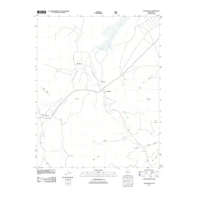
2011 Map of Youngsville
USGS Topo · Published 2011About this map
Youngsville and Coyote serve as the primary hubs of this Rio Arriba County landscape, where the high-desert terrain is marked by a network of ranching and forestry roads. The Coyote Post Office stands as a central landmark for the western settlement, while the Youngsville Cemetery and nearby Youngsville Prospects suggest a history of both community and mineral exploration. The drainage of the Rio Puerco and its tributaries, including Coyote Creek and Rito Encino, define the local topography, carving through landforms like Mesa Naranja and Banco Largo. Evidence of rural habitation and land use is scattered throughout the area, notably at El Cerrito, the C Serrano Cabin, and the Encino Corral, illustrating a pattern of remote settlement oriented around water sources and grazing lands near the striking silhouette of Cerro Pedernal.
Find a feature on this map
38 named features on this map. Tap any name to fly to it.
Don’t see what you’re looking for? This feature index may not catch every label — zoom into the map to look around manually.
Map Details
Editions of this 2011 Youngsville Map
This is the sole edition of this map. No revisions or reprints were ever made.
Other maps of this area

1909 · Gallina
USGS Topo · 1:125,000

1918 · Abiquiu
USGS Topo · 1:125,000

1953 · Canones
USGS Topo · 1:24,000

1953 · Cerro Del Grant
USGS Topo · 1:24,000

1953 · Polvadera Peak
USGS Topo · 1:24,000

1953 · Echo Ampitheater
USGS Topo · 1:24,000

1953 · Arroyo Del Agua
USGS Topo · 1:24,000
1953 · Jarosa
USGS Topo · 1:24,000

1953 · Laguna Peak
USGS Topo · 1:24,000

1953 · Youngsville
USGS Topo · 1:24,000