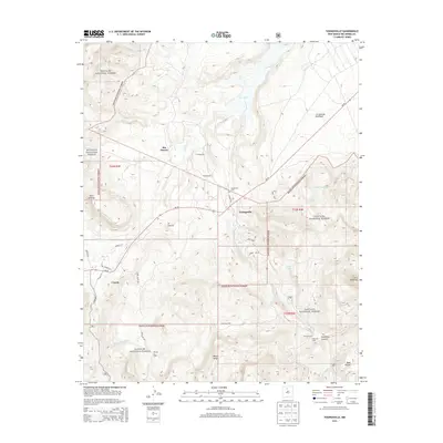
2013 Map of Youngsville
USGS Topo · Published 2013About this map
The high desert landscape of Santa Fe National Forest defines this region of Rio Arriba County, where the village of Youngsville and the settlement of Coyote sit at the crossroads of NM-96 and local routes like CO Road 212. The map documents a rural New Mexican heritage through scattered family-named sites, such as the C Serrano Cabin and E Serrano Cabin, alongside the agricultural infrastructure of the Encino Corral. Water is a critical factor for these communities, indicated by the course of the Rio Puerco and the presence of high-altitude stock tanks like Pinta Tank and Cedro Tank. Dramatic geological features such as the prominent Cerro Pedernal and the broad plateau of Mesa Escoba provide clear landmarks for researchers and historians tracing the settlement patterns and livestock routes that have long characterized this rugged terrain.
Find a feature on this map
43 named features on this map. Tap any name to fly to it.
Don’t see what you’re looking for? This feature index may not catch every label — zoom into the map to look around manually.
Map Details
Editions of this 2013 Youngsville Map
This is the sole edition of this map. No revisions or reprints were ever made.
Other maps of this area

1909 · Gallina
USGS Topo · 1:125,000

1918 · Abiquiu
USGS Topo · 1:125,000

1953 · Canones
USGS Topo · 1:24,000

1953 · Cerro Del Grant
USGS Topo · 1:24,000

1953 · Polvadera Peak
USGS Topo · 1:24,000

1953 · Echo Ampitheater
USGS Topo · 1:24,000

1953 · Arroyo Del Agua
USGS Topo · 1:24,000
1953 · Jarosa
USGS Topo · 1:24,000

1953 · Laguna Peak
USGS Topo · 1:24,000

1953 · Youngsville
USGS Topo · 1:24,000