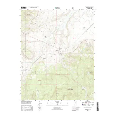
2017 Map of Youngsville
USGS Topo · Published 2017About this map
Youngsville and Coyote anchor this high-elevation landscape within the Santa Fe National Forest, where the transition from mesas to canyons defines the northern New Mexico terrain. The drainage of the Rio Puerco carves through the center of the sheet, supported by tributaries like Rito Encino and Rito de las Sillas. Local history is centered around the Youngsville Cem and the settlement at El Cerrito, reflecting the long-standing ranching and forest-service influence in Rio Arriba County. Massive geologic forms dominate the horizon, from the prominent Cerro Pedernal in the east to the high flats of Mesa Naranja and Mesa Escoba. A network of forest roads, such as Los Piñoneros Rd and Forest Rd 309, provides access to remote livestock water features like Pinta Tank and La Jolla Trick Tank, essential infrastructure for the high-desert economy of this region.
Find a feature on this map
34 named features on this map. Tap any name to fly to it.
Don’t see what you’re looking for? This feature index may not catch every label — zoom into the map to look around manually.
Map Details
Editions of this 2017 Youngsville Map
This is the sole edition of this map. No revisions or reprints were ever made.
Other maps of this area

1909 · Gallina
USGS Topo · 1:125,000

1918 · Abiquiu
USGS Topo · 1:125,000

1953 · Canones
USGS Topo · 1:24,000

1953 · Cerro Del Grant
USGS Topo · 1:24,000

1953 · Polvadera Peak
USGS Topo · 1:24,000

1953 · Echo Ampitheater
USGS Topo · 1:24,000

1953 · Arroyo Del Agua
USGS Topo · 1:24,000
1953 · Jarosa
USGS Topo · 1:24,000

1953 · Laguna Peak
USGS Topo · 1:24,000

1953 · Youngsville
USGS Topo · 1:24,000