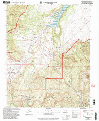
2002 Map of Youngsville
USGS Topo · Published 2003About this map
Youngsville and Coyote anchor this landscape at the intersection of private land grants and national forest system lands. The area is defined by the massive drainage of the Rio Puerco, which flows north toward the Abiquiu Reservoir within the historical boundaries of the Piedra Lumbre Grant. To the south, the Santa Fe National Forest encompasses landmarks such as the iconic Cerro Pedernal and the Chama River Canyon Wilderness. The map reveals the infrastructure of a rural ranching and residential economy, noting the Coyote Elem Sch, the Youngsville Cem, and localized water sources like Coyote Spring and Maestas Spring. Evidence of land management is visible in the network of forest roads and specific sites such as the Serrano Cabin and Encino Corral.
Find a feature on this map
34 named features on this map. Tap any name to fly to it.
Don’t see what you’re looking for? This feature index may not catch every label — zoom into the map to look around manually.
Map Details
Editions of this 2002 Youngsville Map
This is the sole edition of this map. No revisions or reprints were ever made.
Other maps of this area

1909 · Gallina
USGS Topo · 1:125,000

1918 · Abiquiu
USGS Topo · 1:125,000

1953 · Canones
USGS Topo · 1:24,000

1953 · Cerro Del Grant
USGS Topo · 1:24,000

1953 · Polvadera Peak
USGS Topo · 1:24,000

1953 · Echo Ampitheater
USGS Topo · 1:24,000

1953 · Arroyo Del Agua
USGS Topo · 1:24,000
1953 · Jarosa
USGS Topo · 1:24,000

1953 · Laguna Peak
USGS Topo · 1:24,000

1953 · Youngsville
USGS Topo · 1:24,000