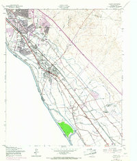
1955 Map of Ysleta
USGS Topo · Published 1967About this map
The Rio Grande defines the international boundary between the United States and Mexico in this mid-century survey of the Lower Valley. This reach of the river, southeast of El Paso, is a landscape shaped by a complex network of irrigation and drainage infrastructure, including the Franklin Canal, Riverside Canal, and numerous lateral branches like the Juan de Herrera Main Lateral. These systems supported the agricultural character of the region, anchored by the Texas Agricultural Experimental Sta and the County Farm.
Find a feature on this map
67 named features on this map. Tap any name to fly to it.
Don’t see what you’re looking for? This feature index may not catch every label — zoom into the map to look around manually.
Map Details
Editions of this 1955 Ysleta Map
3 editions found
Other maps of this area

1896 · El Paso
USGS Topo · 1:125,000

1908 · El Paso
USGS Topo · 1:125,000

1939 · Ysleta
USGS Topo · 1:62,500

1939 · Heuco Tanks
USGS Topo · 1:62,500

1940 · Heuco Tanks
USGS Topo · 1:62,500

1941 · El Paso
USGS Topo · 1:31,680

1941 · Clint
USGS Topo · 1:62,500

1941 · Ysleta
USGS Topo · 1:62,500

1942 · Fort Bliss
USGS Topo · 1:62,500

1943 · El Paso
USGS Topo · 1:31,680