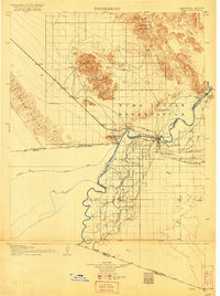
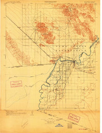
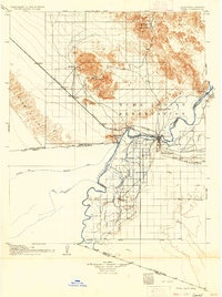
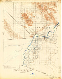
1905 Map of Yuma
USGS Topo · Published 1921About this map
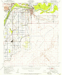
The confluence of the Colorado River and Gila River defines this landscape during the early 20th century, a time of intense irrigation development and mining activity along the California-Arizona border. The settlement of Yuma serves as the regional anchor, flanked by the Yuma Indian Reservation and the sprawling Imperial Canal system that transformed the desert into agricultural land. North of the river, the San Isidro Mountains and Cargo Muchacho range house significant mining operations including the American Mine, American Girl, and the Picacho Mine near Picacho Pk. The southern portion of the map traces the international boundary between the United States and Mexico, showing the early footprint of Somerton and the winding course of the river before its modern channelization. This era's transport is dominated by the Southern Pacific railroad, which connects desert stops like Ogilby and Cactus to the river valley.
Find a feature on this map
43 named features on this map. Tap any name to fly to it.
Don’t see what you’re looking for? This feature index may not catch every label — zoom into the map to look around manually.
Map Details
Editions of this 1905 Yuma Map
5 editions found
Other maps of this area

1903 · Yuma
USGS Topo · 1:125,000

1905 · Yuma
USGS Topo · 1:125,000

1907 · Holtville
USGS Topo · 1:125,000

1926 · Fortuna
USGS Topo · 1:62,500
1929 · Fortuna
USGS Topo · 1:62,500
1929 · Laguna
USGS Topo · 1:62,500
1939 · Red Hill
USGS Topo · 1:62,500
1940 · Yuma
USGS Topo · 1:62,500

1942 · El Centro
USGS Topo · 1:250,000

1942 · Yuma
USGS Topo · 1:250,000