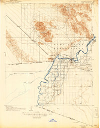
1905 Map of Yuma
USGS Topo · Published 1944About this map
The Colorado River and Gila River converge at the heart of this 1905 survey, illustrating a critical junction of water and rail transport at the dawn of the 20th century. This arid landscape is defined by the heavy infrastructure of the Southern Pacific railroad and the early irrigation efforts of the Imperial Canal. The town of Yuma serves as a central hub, surrounded by outlying agricultural and mining developments such as Somerton, Yuma Heights, and the Yuma Indian Reservation.
Find a feature on this map
41 named features on this map. Tap any name to fly to it.
Don’t see what you’re looking for? This feature index may not catch every label — zoom into the map to look around manually.
Map Details
Editions of this 1905 Yuma Map
5 editions found
Other maps of this area

1903 · Yuma
USGS Topo · 1:125,000

1905 · Yuma
USGS Topo · 1:125,000

1907 · Holtville
USGS Topo · 1:125,000

1926 · Fortuna
USGS Topo · 1:62,500

1929 · Fortuna
USGS Topo · 1:62,500

1929 · Laguna
USGS Topo · 1:62,500

1939 · Red Hill
USGS Topo · 1:62,500

1940 · Yuma
USGS Topo · 1:62,500

1942 · El Centro
USGS Topo · 1:250,000

1942 · Yuma
USGS Topo · 1:250,000