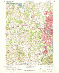
1961 Map of Zanesville West
USGS Topo · Published 1972About this map
Zanesville sits at the confluence of the Licking River and Muskingum River, serving as a busy industrial and transportation hub in the early 1960s. The urban core is flanked by numerous neighborhoods including North Zanesville, South Zanesville, and Merian Heights, with the County Fairground and various institutions like the Home for Aged and Hospital characterizing the mid-century city layout. To the west, the landscape transitions into the hills of Hopewell and Springfield townships, where several strip mines operate near Grange Hall.
Find a feature on this map
94 named features on this map. Tap any name to fly to it.
Don’t see what you’re looking for? This feature index may not catch every label — zoom into the map to look around manually.
Map Details
Editions of this 1961 Zanesville West Map
4 editions found

Other maps of this area

1908 · Conesville
USGS Topo · 1:62,500

1910 · Frazeysburg
USGS Topo · 1:62,500

1910 · Philo
USGS Topo · 1:62,500

1910 · Zanesville
USGS Topo · 1:62,500

1910 · Conesville
USGS Topo · 1:62,500

1947 · Columbus
USGS Topo · 1:250,000

1949 · Clarksburg
USGS Topo · 1:250,000

1950 · Marion
USGS Topo · 1:250,000

1951 · Canton
USGS Topo · 1:250,000

1953 · Canton
USGS Topo · 1:250,000