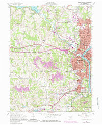
1961 Map of Zanesville West
USGS Topo · Published 1985About this map
The Licking River and Muskingum River converge in this mid-century portrait of Zanesville, documenting the city's complex industrial and transportation geography. Rail lines like the Baltimore and Ohio and Pennsylvania carve through the landscape, connecting the urban core to outlying settlements like North Zanesville and South Zanesville. This 1985 edition, which includes 1983 revisions, illustrates the expansion of suburban neighborhoods such as Zanesville Terrace and Meadowbrook alongside long-standing local institutions like the County Fairground and the Home for Aged.
Find a feature on this map
90 named features on this map. Tap any name to fly to it.
Don’t see what you’re looking for? This feature index may not catch every label — zoom into the map to look around manually.
Map Details
Editions of this 1961 Zanesville West Map
4 editions found

Other maps of this area

1908 · Conesville
USGS Topo · 1:62,500

1910 · Frazeysburg
USGS Topo · 1:62,500

1910 · Philo
USGS Topo · 1:62,500

1910 · Zanesville
USGS Topo · 1:62,500

1910 · Conesville
USGS Topo · 1:62,500

1947 · Columbus
USGS Topo · 1:250,000

1949 · Clarksburg
USGS Topo · 1:250,000

1950 · Marion
USGS Topo · 1:250,000

1951 · Canton
USGS Topo · 1:250,000

1953 · Canton
USGS Topo · 1:250,000