
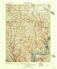
1908 Map of Zelienople
USGS Topo · Published 1963About this map
Connoquenessing Creek and Slippery Rock Creek carve through the landscape of Butler, Lawrence, and Beaver Counties during this early twentieth-century survey. The industrial and agricultural heartbeat of the region is centered on Zelienople and Harmony, where the Baltimore and Ohio and Pittsburgh and Western railroads converge at Harmony Junction. The map captures a transition in transportation, showing the old Pittsburgh Mercer Road alongside newer rail lines and the remains of early industry at Old Furnace.
Find a feature on this map
115 named features on this map. Tap any name to fly to it.
Don’t see what you’re looking for? This feature index may not catch every label — zoom into the map to look around manually.
Map Details
Editions of this 1908 Zelienople Map
This is the sole edition of this map. No revisions or reprints were ever made.
Other maps of this area

1901 · Beaver
USGS Topo · 1:62,500

1902 · New Castle
USGS Topo · 1:62,500

1904 · Newcastle
USGS Topo · 1:62,500

1904 · Beaver
USGS Topo · 1:62,500

1905 · Neshannock
USGS Topo · 1:62,500

1906 · Sewickley
USGS Topo · 1:62,500

1907 · Neshannock
USGS Topo · 1:62,500

1908 · Sewickley
USGS Topo · 1:62,500
1908 · New Kensington
USGS Topo · 1:62,500

1909 · Butler
USGS Topo · 1:62,500