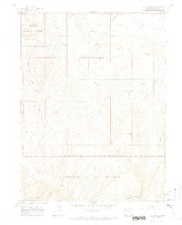
1966 Map of Zenobia Peak
USGS Topo · Published 1970About this map
Dinosaur National Monument encompasses the majority of this mid-1960s landscape, where the high ridges of Douglas Mountain overlook a complex network of canyons and draws. The high point at Zenobia Peak is marked by a Lookout Tower, serving as a primary observation point above the surrounding terrain. To the south, the Yampa River carves through the monument's southern boundary, creating a deep corridor that separates the northern highlands from the stark topography of Starvation Valley.
Find a feature on this map
31 named features on this map. Tap any name to fly to it.
Don’t see what you’re looking for? This feature index may not catch every label — zoom into the map to look around manually.
Map Details
Editions of this 1966 Zenobia Peak Map
3 editions found
Other maps of this area

1907 · Rangely
USGS Topo · 1:125,000

1910 · Rangely
USGS Topo · 1:125,000

1954 · Hells Canyon
USGS Topo · 1:24,000

1954 · Canyon of Lodore South
USGS Topo · 1:24,000

1954 · Canyon of Lodore North
USGS Topo · 1:24,000

1954 · Vernal
USGS Topo · 1:250,000

1958 · Vernal
USGS Topo · 1:250,000

1960 · Vernal
USGS Topo · 1:250,000

1962 · Tanks Peak
USGS Topo · 1:24,000
1962 · Haystack Rock
USGS Topo · 1:24,000