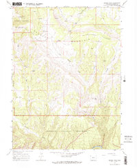
1966 Map of Zenobia Peak
USGS Topo · Published 1979About this map
Douglas Mountain dominates this portion of Moffat County, providing a high-elevation backdrop for the isolated ranching outposts and rugged watercourses of northwestern Colorado. The survey, field-checked in the mid-1960s, documents a landscape where life centers on remote landmarks like Currant Springs Ranch, Tisdels Place, and Browns Cabin. These sites are linked by a network of unimproved roads and a high-clearance Jeep Trail, reflecting the difficult access typical of the region before modern infrastructure.
Find a feature on this map
29 named features on this map. Tap any name to fly to it.
Don’t see what you’re looking for? This feature index may not catch every label — zoom into the map to look around manually.
Map Details
Editions of this 1966 Zenobia Peak Map
3 editions found
Other maps of this area

1907 · Rangely
USGS Topo · 1:125,000

1910 · Rangely
USGS Topo · 1:125,000

1954 · Hells Canyon
USGS Topo · 1:24,000

1954 · Canyon of Lodore South
USGS Topo · 1:24,000

1954 · Canyon of Lodore North
USGS Topo · 1:24,000

1954 · Vernal
USGS Topo · 1:250,000

1958 · Vernal
USGS Topo · 1:250,000

1960 · Vernal
USGS Topo · 1:250,000

1962 · Tanks Peak
USGS Topo · 1:24,000
1962 · Haystack Rock
USGS Topo · 1:24,000