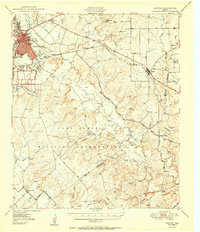
1950 Map of Zephyr
USGS Topo · Published 1950About this map
The Camp Bowie Military Reservation dominates the center of this landscape, its expansive boundaries stretching across the terrain southwest of Zephyr. To the northwest, the city of Brownwood is shown in detail, including the Brownwood Country Club and the residential growth near Early High School. The era's transportation network is anchored by the Gulf Colorado and Santa Fe railroad, which parallels the Williams Ranch Road through the hills. Genealogists will find a wealth of specific local landmarks, from rural burial grounds like Elkins Cemetery and Blanket Springs Cemetery to several distinct creek crossings such as Wood Crossing and Van Crossing. The map captures the rural transition of the Brown County and Mills County line, where small communities like Ebony, Fisk, and Groves serve as the primary landmarks in an area defined by the winding paths of Pecan Bayou and its many tributaries.
Find a feature on this map
44 named features on this map. Tap any name to fly to it.
Don’t see what you’re looking for? This feature index may not catch every label — zoom into the map to look around manually.
Map Details
Editions of this 1950 Zephyr Map
2 editions found

Other maps of this area

1885 · San Saba
USGS Topo · 1:125,000

1887 · Coleman
USGS Topo · 1:125,000

1889 · Brownwood
USGS Topo · 1:125,000

1889 · Coleman
USGS Topo · 1:125,000

1894 · Brady
USGS Topo · 1:125,000

1894 · Brownwood
USGS Topo · 1:125,000

1894 · San Saba
USGS Topo · 1:125,000

1924 · Brownwood Reservoir Site
USGS Topo · 1:48,000

1925 · Brownwood 3-b
USGS Topo · 1:48,000

1925 · San Saba 2-a
USGS Topo · 1:48,000