1920s Maps of Maricopa County, Arizona
Explore 5 historic maps of Maricopa County from the 1920s. These maps offer a rare glimpse into what life looked like during the 1920s — showing old roads, neighborhoods, homes, and landmarks that have changed or disappeared over time.
Whether you're researching your family's past, planning a metal detecting trip, or studying how Maricopa County's landscape evolved across the 1920s, these high-resolution maps are a powerful tool for exploring the history of this region.
- Focus on a specific era: All maps on this page are from the 1920s, giving you a focused view of this time period.
- See what’s changed: Compare century-old streets, trails, and buildings to today's modern landscape using overlays and satellite layers.
- Research with precision: Use these maps for genealogy, historical research, land use analysis, or educational projects.
- View, download, or print: Maps are fully viewable online in high resolution, and can be downloaded or printed for your own records.
Start exploring Maricopa County's history through authentic maps from the 1920s. This is your window into the past.
Maricopa County, AZ maps
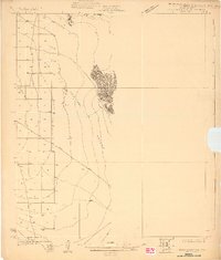
(5)- 1923 Map of Signal
 1923 Signal1923 Print · USGSWestern Arizona in the early twenties was a landscape of isolated mining camps and vital desert springs. Genealogists and historians can trace the footprint of early settlements like Signal and Swansea or locate remote outposts such as Owen and Butler well.
 - 1927 Map of Aguila Mountains
 1927 Aguila Mountains1927 Print · USGSThe desert of Yuma County is captured in the late twenties, showing the region as a wide-open basin organized by early township surveys. Researchers can trace the original path of Yager Road as it cuts across the San Cristobal Valley.2 unique versions available
 - 1927 Map of Hyder, 1961 Print
 1927 Hyder1961 Print · USGSThe arid basins of Yuma County are captured here in the late twenties just as regional transportation routes were maturing. Trace the early desert corridor along the Southern Pacific rail line and the historic Old Yuma-Phoenix Road.
 - 1929 Map of Aztec
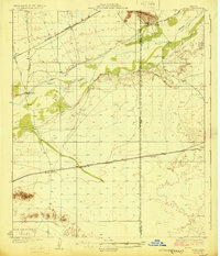 1929 Aztec1929 Print · USGSYuma and Maricopa counties at the end of the 1920s reveal a landscape shaped by the rail and the river. Researchers can trace the desert infrastructure of the Southern Pacific through Aztec and find historical water sites like Agua Caliente and Baragans Well.2 unique versions available
 - 1929 Map of Turret Peak, 1958 Print
 1929 Turret Peak1958 Print · USGSYavapai County ranching and mining reach their peak in the late twenties along the winding Verde River. Researchers can trace the legacy of early families and industrial ventures at the United Arizona Mine, Brown Springs Ranch, and Anchor Ranch.3 unique versions available
End of results
Showing maps 1-5 of 5
Top cities of Maricopa County
- Phoenix historical maps
- Mesa historical maps
- Chandler historical maps
- Glendale historical maps
- Scottsdale historical maps
- Gilbert historical maps
See more
Frequently asked questions
- What are the different types of historical maps available for Maricopa County?
- What is the oldest map of Maricopa County?
- Where can I purchase historical maps of Maricopa County for my home or office?
- Where can I download high-res historical maps of Maricopa County?
- Are there historical topographic maps available for Maricopa County?
- Is there historical aerial imagery available for Maricopa County?
- Where are historical maps of Maricopa County sourced from?