1900-1909 Maps of Maricopa County, Arizona
Explore 14 historic maps of Maricopa County from 1900-1909. These maps offer a rare glimpse into what life looked like during the 1900s — showing old roads, neighborhoods, homes, and landmarks that have changed or disappeared over time.
Whether you're researching your family's past, planning a metal detecting trip, or studying how Maricopa County's landscape evolved across the 1900s, these high-resolution maps are a powerful tool for exploring the history of this region.
- Focus on a specific era: All maps on this page are from the 1900s, giving you a focused view of this time period.
- See what’s changed: Compare century-old streets, trails, and buildings to today's modern landscape using overlays and satellite layers.
- Research with precision: Use these maps for genealogy, historical research, land use analysis, or educational projects.
- View, download, or print: Maps are fully viewable online in high resolution, and can be downloaded or printed for your own records.
Start exploring Maricopa County's history through authentic maps from the 1900s. This is your window into the past.
Maricopa County, AZ maps
(14)- 1900 Map of Florence, 1956 Print
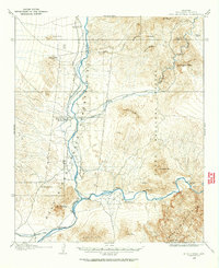
 1900 Florence1956 Print · USGSArizona's mining and ranching frontiers are mapped here at the dawn of the century as the Gila River valley begins its growth. Researchers can trace historic family holdings like Arnett Ranch and early industrial camps at Silver King or the Silver Bell Mine.
 - 1902 Map of Florence
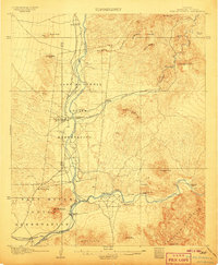
 1902 Florence1902 Print · USGSFlorence and the Gila River valley are captured here at the turn of the century during the peak of early Arizona mining and ranching. Researchers can locate vanished settlements and family sites like Silver King, Adamsville, and the Silver Bell Mine.5 unique versions available
 - 1903 Map of Bradshaw Mountains
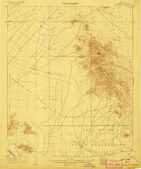
 1903 Bradshaw Mountains1903 Print · USGSArizona's mining heartland comes into focus during the territorial era as high-altitude camps and smelters reached their peak. Trace the early footprints of Crown King, Walker, and Tiptop alongside the winding route of the Prescott and Eastern R.R.4 unique versions available
 - 1903 Map of Congress, 1962 Print
 1903 Congress1962 Print · USGSYavapai County's high desert mining camps and cattle ranches are captured here at the turn of the century. Genealogists and historians can trace the early rail-and-mine economy through sites like Congress Junction, Octave, and the Walnut Grove Dam.
 - 1904 Map of Camelback
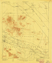
 1904 Camelback1904 Print · USGSMaricopa County is captured at the dawn of the twentieth century, showing a desert landscape before the rise of the Phoenix suburbs. Researchers can trace the foundational Arizona Canal and early landmarks like Camelback Mtn and Thompson Pk.
 - 1904 Map of Congress
 1904 Congress1904 Print · USGSArizona's mining heartland in Yavapai County comes alive during this early boom era. Genealogists and historians can trace the foundations of Congress Junction, the bustling Congress Mine, and the legendary gold camp at Stanton along the Hassayampa River.3 unique versions available
 - 1904 Map of Desert Well, 1958 Print
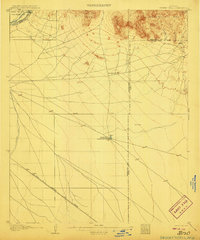
 1904 Desert Well1958 Print · USGSArizona's Salt River Valley comes to life in the early 1900s as a landscape of irrigation canals and desert outposts. Local historians can trace the early footprint of Higley, locate the specific Desert Well, and follow the path of the Santa Fe Prescott and Phoenix RR.
 - 1904 Map of Ft. McDowell, 1960 Print
 1904 Ft. McDowell1960 Print · USGSMaricopa County's river valleys and early ranching outposts are captured here at the turn of the century. Genealogists and historians can locate early homesteads like Asher's Ranch and the site of the Limekiln near the Salt River.
 - 1906 Map of Camelsback
 1906 Camelsback1906 Print · USGSArizona's high desert near Phoenix is captured here at the turn of the century, when the landscape was defined by mountain ranges and early water infrastructure. Genealogists and historians can trace the paths of the Old Verde Canal and the Arizona Canal or locate landmarks like Thompson Pk and Mountain Spring.3 unique versions available
 - 1906 Map of Ft. McDowell
 1906 Ft. McDowell1906 Print · USGSMaricopa County's river valleys and desert foothills were defined by a network of ranching homesteads and tribal lands in the early 1900s. Researchers can trace the early foundations of Arizona water management near the Arizona Dam and locate family outposts like Otero's Ranch and Stewarts Ranch.3 unique versions available
 - 1906 Map of Desert Well
 1906 Desert Well1906 Print · USGSArizona's Salt River valley was transitioning from open range to an irrigated landscape in the years after the turn of the century. Trace the early routes of the Santa Fe Prescott and Phoenix RR and locate pioneer outposts like Buchanan's Ranch and the Desert Well.3 unique versions available
 - 1907 Map of Sacaton
 1907 Sacaton1907 Print · USGSThe Gila River Valley comes alive in this survey from the early 1900s, showing the early infrastructure of the Gila River Indian Reservation. Trace the legacy of desert ranching at Andrada's Ranch or find the early site of Blackwater Chapel.4 unique versions available
 - 1907 Map of Roosevelt, 1956 Print
 1907 Roosevelt1956 Print · USGSCentral Arizona at the birth of the reclamation era centers on the engineering of the Roosevelt Dam and the waters of the Salt River. Genealogists and historians can trace numerous early family holdings like Clanton's Ranch, the stage stop at Schells Station, and the remote settlement of Apacheria.2 unique versions available
 - 1909 Map of Four Peaks
 1909 Four Peaks1909 Print · USGSThe central Arizona wilderness at the start of the century reveals a land of isolated ranching outposts and rugged mountain passes. Researchers can trace the early cattle frontier at Sunflower Ranch, find the original Mormon Flats, and locate the historic Schells Station.2 unique versions available
End of results
Showing maps 1-14 of 14
Top cities of Maricopa County
- Phoenix historical maps
- Mesa historical maps
- Chandler historical maps
- Glendale historical maps
- Scottsdale historical maps
- Gilbert historical maps
See more
Frequently asked questions
- What are the different types of historical maps available for Maricopa County?
- What is the oldest map of Maricopa County?
- Where can I purchase historical maps of Maricopa County for my home or office?
- Where can I download high-res historical maps of Maricopa County?
- Are there historical topographic maps available for Maricopa County?
- Is there historical aerial imagery available for Maricopa County?
- Where are historical maps of Maricopa County sourced from?