2000-2009 Maps of Navajo County, Arizona
Explore 2 historic maps of Navajo County from 2000-2009. These maps offer a rare glimpse into what life looked like during the 2000s — showing old roads, neighborhoods, homes, and landmarks that have changed or disappeared over time.
Whether you're researching your family's past, planning a metal detecting trip, or studying how Navajo County's landscape evolved across the 2000s, these high-resolution maps are a powerful tool for exploring the history of this region.
- Focus on a specific era: All maps on this page are from the 2000s, giving you a focused view of this time period.
- See what’s changed: Compare century-old streets, trails, and buildings to today's modern landscape using overlays and satellite layers.
- Research with precision: Use these maps for genealogy, historical research, land use analysis, or educational projects.
- View, download, or print: Maps are fully viewable online in high resolution, and can be downloaded or printed for your own records.
Start exploring Navajo County's history through authentic maps from the 2000s. This is your window into the past.
Navajo County, AZ maps
(2)- 2004 Map of Gentry Mountain, 2006 Print
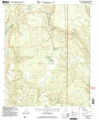 2004 Gentry Mountain2006 Print · USGSArizona's high ranching country comes into focus in the early 2000s along the Gila and Navajo county line. Genealogists and researchers can trace local landmarks like Q Ranch, the unique Catholic Peak, and historical mining sites near Vosburg Gulch.
 - 2004 Map of Parallel Canyon, 2006 Print
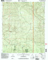 2004 Parallel Canyon2006 Print · USGSArizona's Mogollon Rim country is captured here during the early 2000s, where national forest land meets tribal territory. Researchers can trace land use through cattle-ranching features like the Nail Ranch and remote water sources including Frog Pond and Carroll Spring.
End of results
Showing maps 1-2 of 2
Top cities of Navajo County
- Show Low historical maps
- Winslow historical maps
- Snowflake historical maps
- Kayenta historical maps
- Holbrook historical maps
- Pinetop-Lakeside historical maps
See more
Frequently asked questions
- What are the different types of historical maps available for Navajo County?
- What is the oldest map of Navajo County?
- Where can I purchase historical maps of Navajo County for my home or office?
- Where can I download high-res historical maps of Navajo County?
- Are there historical topographic maps available for Navajo County?
- Is there historical aerial imagery available for Navajo County?
- Where are historical maps of Navajo County sourced from?