1920s Maps of Pinal County, Arizona
Explore 5 historic maps of Pinal County from the 1920s. These maps offer a rare glimpse into what life looked like during the 1920s — showing old roads, neighborhoods, homes, and landmarks that have changed or disappeared over time.
Whether you're researching your family's past, planning a metal detecting trip, or studying how Pinal County's landscape evolved across the 1920s, these high-resolution maps are a powerful tool for exploring the history of this region.
- Focus on a specific era: All maps on this page are from the 1920s, giving you a focused view of this time period.
- See what’s changed: Compare century-old streets, trails, and buildings to today's modern landscape using overlays and satellite layers.
- Research with precision: Use these maps for genealogy, historical research, land use analysis, or educational projects.
- View, download, or print: Maps are fully viewable online in high resolution, and can be downloaded or printed for your own records.
Start exploring Pinal County's history through authentic maps from the 1920s. This is your window into the past.
Pinal County, AZ maps
(5)- 1922 Map of Red Rock No 2
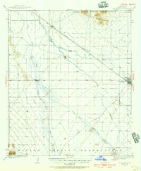
 1922 Red Rock No 21922 Print · USGSPinal County at the dawn of statehood reveals a desert landscape being transformed by irrigation and early highways. Researchers can trace the development of the Picacho Reservoir and early rural landmarks like the Kenilworth School.
 - 1922 Map of Casa Grande, 1956 Print
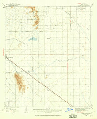
 1922 Casa Grande1956 Print · USGSPinal County in the early twenties shows a landscape shaped by tribal lands and the railroad. Genealogists and historians can trace the early layout of Casa Grande, the rail siding at Nunez, and the village of Chuichu.2 unique versions available
 - 1922 Map of Signal Peak, 1959 Print
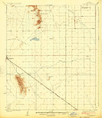
 1922 Signal Peak1959 Print · USGSPinal County's desert corridor is captured in the early 1920s as the railroad and new canals began to transform the arid landscape. Genealogists and historians can trace the early footprints of Casa Grande, Arizola, and the American Boy Mine.2 unique versions available
 - 1924 Map of Signal Peak
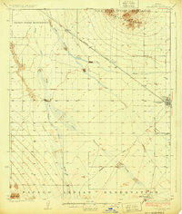
 1924 Signal Peak1924 Print · USGSPinal County in the early twenties shows a landscape of desert peaks and growing rail hubs along the Southern Pacific Railroad. Trace the early development of Casa Grande and Eloy near the American Boy Mine and rural Selma School.3 unique versions available
 - 1924 Map of Casa Grande
 1924 Casa Grande1924 Print · USGSThe Santa Cruz River valley in the early 1920s shows the convergence of rail travel and early desert irrigation. Genealogists and historians can trace the rail sidings of Bon and Nunez or locate the village of Chiu Chuischu within the Papago Indian Reservation.
End of results
Showing maps 1-5 of 5
Top cities of Pinal County
- San Tan Valley historical maps
- Maricopa historical maps
- Casa Grande historical maps
- Apache Junction historical maps
- Florence historical maps
- Eloy historical maps
See more
Frequently asked questions
- What are the different types of historical maps available for Pinal County?
- What is the oldest map of Pinal County?
- Where can I purchase historical maps of Pinal County for my home or office?
- Where can I download high-res historical maps of Pinal County?
- Are there historical topographic maps available for Pinal County?
- Is there historical aerial imagery available for Pinal County?
- Where are historical maps of Pinal County sourced from?