1970s Maps of Pinal County, Arizona
Explore 25 historic maps of Pinal County from the 1970s. These maps offer a rare glimpse into what life looked like during the 1970s — showing old roads, neighborhoods, homes, and landmarks that have changed or disappeared over time.
Whether you're researching your family's past, planning a metal detecting trip, or studying how Pinal County's landscape evolved across the 1970s, these high-resolution maps are a powerful tool for exploring the history of this region.
- Focus on a specific era: All maps on this page are from the 1970s, giving you a focused view of this time period.
- See what’s changed: Compare century-old streets, trails, and buildings to today's modern landscape using overlays and satellite layers.
- Research with precision: Use these maps for genealogy, historical research, land use analysis, or educational projects.
- View, download, or print: Maps are fully viewable online in high resolution, and can be downloaded or printed for your own records.
Start exploring Pinal County's history through authentic maps from the 1970s. This is your window into the past.
Pinal County, AZ maps
(25)- 1971 Map of Phoenix
 1971 Phoenix1971 Print · USGSCentral Arizona at the start of the seventies shows a desert metropolis expanding toward the Sun Valley retirement boom. Trace the growth of Sun City and Glendale, or locate remote historic sites like the Vulture Gold Mine and Nottbusch Cemetery.
 - 1971 Map of Pima Butte, 1972 Print
 1971 Pima Butte1972 Print · USGSThe Gila River valley south of Phoenix comes into focus in the early 1970s, revealing the intersection of desert ranching and braided river systems. Genealogists and local historians can trace the footprint of Lone Butte Ranch and the natural path of Vekol Wash.
 - 1971 Map of Gila Butte, 1972 Print
 1971 Gila Butte1972 Print · USGSThe Pinal County desert floor meets irrigated agriculture in the early 1970s, as seen from high-altitude aerial photography. Trace the rural layout of Ocotillo and Bapchule, or locate the prominent landmark of Gila Butte overlooking the Gila River.
 - 1971 Map of Gila Butte SE, 1972 Print
 1971 Gila Butte SE1972 Print · USGSPinal County's desert agriculture and high peaks are captured here in the early seventies through detailed aerial photogrammetry. Researchers can trace the sharp line between the Gila River and the rising slopes of the Sacaton Mountains.
 - 1971 Map of Sacaton NE, 1972 Print
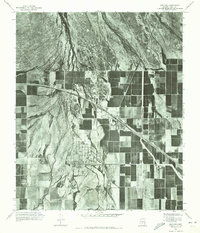
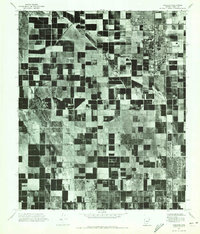
 1971 Sacaton NE1972 Print · USGSPinal County agriculture meets the desert foothills in the early seventies, capturing the precise layout of Arizona’s irrigation-driven landscape. You can trace the path of Queen Creek and the rising slopes of Goldmine Mountain amidst the geometric farm grids.
 - 1971 Map of Apache Junction, 1972 Print
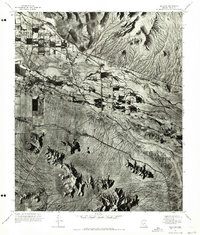
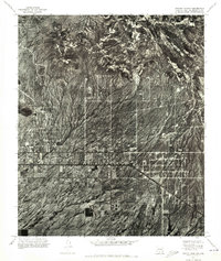 1971 Apache Junction1972 Print · USGSApache Junction emerges from the desert floor in the early seventies, shown here in a detailed aerial orthophotomosaic. Researchers can trace the mid-century street grid and early development patterns of Apache Junction against the untamed desert terrain.
 - 1971 Map of Casa Grande East, 1972 Print
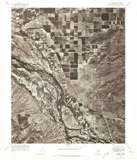
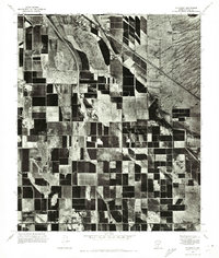
 1971 Casa Grande East1972 Print · USGSCentral Arizona's agricultural landscape is seen in transition during the early seventies as irrigation transforms the desert around Casa Grande. Genealogists and researchers can trace the early city grid and remote features like Lake in the Desert and the high ground of Signal Peak.
 - 1971 Map of Maricopa, 1972 Print
 1971 Maricopa1972 Print · USGSMaricopa and the surrounding Pinal County desert are shown as they appeared in the early seventies, dominated by an expanding grid of agricultural development. Researchers can trace the layout of the Ak Chin community and the natural path of Vekol Wash.
 - 1971 Map of Casa Grande West, 1972 Print
 1971 Casa Grande West1972 Print · USGSArizona's desert landscape meets organized agriculture in the early seventies as the desert begins to yield to development. Trace the intersection of the Sacaton Mountains and the expanding irrigation networks near Casa Grande and the Santa Cruz Wash.
 - 1971 Map of Desert Well, 1972 Print
 1971 Desert Well1972 Print · USGSIn the early 1970s, the landscape around Pinal and Maricopa counties was a mix of military testing and expanding desert agriculture. Researchers can trace the layout of the Desert Proving Grounds and the runway at Rittenhouse Air Force Auxiliary Field.
 - 1971 Map of Antelope Peak NE, 1972 Print
 1971 Antelope Peak NE1972 Print · USGSPinal County agriculture is captured at its early 1970s height in this detailed orthophotoquad survey. Researchers can trace the geometric field patterns and the natural course of Vekol Wash as it existed decades ago.
 - 1971 Map of Chandler Heights, 1972 Print
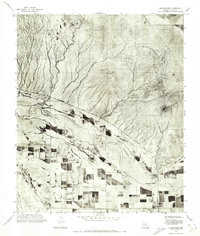
 1971 Chandler Heights1972 Print · USGSThe agricultural grid and desert foothills of Pinal and Maricopa counties are seen in detail in the early 1970s. Researchers can trace the layout of citrus groves in Chandler Heights and the drainage patterns of Queen Creek below the Goldmine Mountains.
 - 1971 Map of Laveen, 1972 Print
 1971 Laveen1972 Print · USGSMaricopa County agriculture meets the desert river bottom in the early seventies, capturing the transition from farm to field. Local researchers can trace the development of Laveen and the riverfront settlement of Komatke along the winding Gila River.
 - 1971 Map of Sacaton Butte, 1972 Print
 1971 Sacaton Butte1972 Print · USGSPinal County agriculture and desert landscapes are frozen in time during the early seventies in this aerial survey. Genealogists and local historians can pinpoint the layout of Casa Blanca and the terrain surrounding Sacaton Butte as they appeared decades ago.
 - 1971 Map of Blackwater, 1972 Print
 1971 Blackwater1972 Print · USGSBlackwater and the surrounding Gila River Indian Community are captured here in the early seventies during a period of expanding desert agriculture. Researchers can trace the path of the Gila River and the settlement of Blackwater against the backdrop of Twin Buttes.
 - 1971 Map of Coolidge, 1972 Print
 1971 Coolidge1972 Print · USGSPinal County's agricultural heartland is documented in the early 1970s through this aerial-based survey. Local researchers can trace the development of the irrigation grid and the historic footprints of Coolidge, Randolph, and Eleven Mile Corner.
 - 1971 Map of Montezuma Peak, 1972 Print
 1971 Montezuma Peak1972 Print · USGSThe desert landscape of Pinal and Maricopa counties is captured in the early 1970s through this detailed aerial survey. Researchers can trace the natural drainage patterns of the Santa Cruz Wash and the prominent heights of Montezuma Peak near the Gila River.
 - 1971 Map of Enid, 1972 Print
 1971 Enid1972 Print · USGSThe arid landscape near Enid is captured in the early seventies, showing the sharp line between desert drainage and irrigated fields. Genealogists and researchers can trace the rail corridor and the scattered structures of Palo Verde.
 - 1971 Map of Sacaton, 1972 Print
 1971 Sacaton1972 Print · USGSThe Pinal County desert floor meets the mountains in the early 1970s, showcasing the agricultural development near the Gila River. Trace the settlement patterns of Sacaton and identify local high points like Sacaton Pk and the Santan Mountains.
 - 1971 Map of Stanfield, 1972 Print
 1971 Stanfield1972 Print · USGSThe agricultural landscape of Pinal County is captured in the early seventies, showing a highly developed grid of desert farm plots. Local historians can trace the early footprint of Stanfield and the natural course of the Santa Cruz Wash across the terrain.
 - 1971 Map of Gila Butte NW, 1972 Print
 1971 Gila Butte NW1972 Print · USGSPinal and Maricopa counties appear in the early 1970s as a study in desert irrigation and military aviation. Researchers can trace the agricultural footprint around Bapchule, the natural course of the Gila River, and the Goodyear Air Force Auxiliary Airfield.
 - 1972 Map of Oak Grove Canyon, 1975 Print
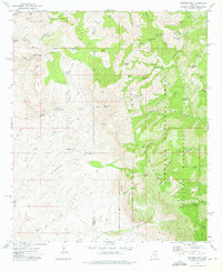
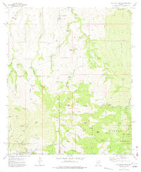 1972 Oak Grove Canyon1975 Print · USGSArizona's remote Galiuro Mountains are shown in the early 1970s, during a period when mining and ranching still shaped the high desert landscape. Genealogists and historians can trace family-named sites and claims like Parsons Grove, Fourmile Ranch, and the Bluebird Mine.2 unique versions available
 - 1972 Map of Rhodes Peak, 1975 Print
 1972 Rhodes Peak1975 Print · USGSThe Galiuro Mountains take center stage in the 1970s, showing a rugged landscape defined by deep canyons and isolated ranching outposts. Researchers can trace historical mineral sites like Magma Mine or locate early water sources such as Mailbox Well and Rhodes Ranch.2 unique versions available
 - 1972 Map of Booger Canyon, 1975 Print
 1972 Booger Canyon1975 Print · USGSThe rugged canyonlands of Graham and Pinal counties appear in the early 1970s, as the San Carlos Indian Reservation meets the Aravaipa Canyon. Genealogists and researchers can trace local landmarks like Salazar Cem, ancient Cliff Dwelling sites, and the Ash Creek Dam.2 unique versions available
 - 1972 Map of Kielberg Canyon, 1975 Print
 1972 Kielberg Canyon1975 Print · USGSSoutheastern Arizona rangeland and canyon country are preserved in this early 1970s survey of the Galiuro Mountains. Researchers can trace old stock-raising and mining sites like YLE Ranch, the 16 to 1 Mine, and Peters Well.2 unique versions available
End of results
Showing maps 1-25 of 25
Top cities of Pinal County
- San Tan Valley historical maps
- Maricopa historical maps
- Casa Grande historical maps
- Apache Junction historical maps
- Florence historical maps
- Eloy historical maps
See more
Frequently asked questions
- What are the different types of historical maps available for Pinal County?
- What is the oldest map of Pinal County?
- Where can I purchase historical maps of Pinal County for my home or office?
- Where can I download high-res historical maps of Pinal County?
- Are there historical topographic maps available for Pinal County?
- Is there historical aerial imagery available for Pinal County?
- Where are historical maps of Pinal County sourced from?