1990s Maps of Pinal County, Arizona
Explore 38 historic maps of Pinal County from the 1990s. These maps offer a rare glimpse into what life looked like during the 1990s — showing old roads, neighborhoods, homes, and landmarks that have changed or disappeared over time.
Whether you're researching your family's past, planning a metal detecting trip, or studying how Pinal County's landscape evolved across the 1990s, these high-resolution maps are a powerful tool for exploring the history of this region.
- Focus on a specific era: All maps on this page are from the 1990s, giving you a focused view of this time period.
- See what’s changed: Compare century-old streets, trails, and buildings to today's modern landscape using overlays and satellite layers.
- Research with precision: Use these maps for genealogy, historical research, land use analysis, or educational projects.
- View, download, or print: Maps are fully viewable online in high resolution, and can be downloaded or printed for your own records.
Start exploring Pinal County's history through authentic maps from the 1990s. This is your window into the past.
Pinal County, AZ maps
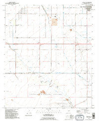
(38)- 1992 Map of Casa Grande West
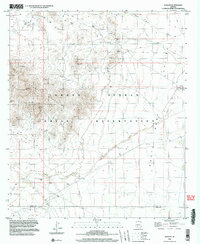
 1992 Casa Grande West1992 Print · USGSCasa Grande is shown in the early nineties during a period of transition between its mining roots and modern expansion. Researchers can trace the extensive Open Pit Mine works or locate local landmarks like Saguaro Sch and the Mormon Battalion Historical Monument.
 - 1992 Map of Eloy North, 1995 Print
 1992 Eloy North1995 Print · USGSNorth of Eloy in the early nineties, the desert floor was transformed by massive irrigation projects and expanding desert communities. Genealogists and local historians can locate early schools like Toltec Sch and Ceriel Sch, or trace the paths of the Casa Grande Canal and Santa Rosa Canal.
 - 1992 Map of Double Peak, 1995 Print
 1992 Double Peak1995 Print · USGSPinal County agriculture and desert terrain meet in the early nineties, where a complex irrigation system supports the arid basin. Researchers can trace the path of the Santa Rosa Canal and find local landmarks like Double Peak and the Landing Strip.
 - 1992 Map of Picacho Reservoir, 1995 Print
 1992 Picacho Reservoir1995 Print · USGSPinal County's desert irrigation system is captured here in the early nineties, showing the vital network of the Tucson Aqueduct. Trace the complex water infrastructure including the Florence Casa Grande Canal and landmarks like the Brady Pumping Plant.
 - 1992 Map of Chuichu, 1995 Print
 1992 Chuichu1995 Print · USGSThe Pinal County desert south of Casa Grande is documented here in the early nineties, showing the vital water systems and communities of the Tohono O'odham Nation. Genealogists and historians can trace local landmarks like the Ocatillo Sch, the Chuichu settlement, and the local Cemetery.
 - 1992 Map of Coolidge, 1995 Print
 1992 Coolidge1995 Print · USGSCoolidge and the surrounding Gila River valley are captured in the early 1990s, showcasing a landscape of ancient ruins and modern irrigation. Genealogists and historians can trace the development of Randolph, locate the Mary T O'Brien Sch, and explore the grounds of the Casa Grande National Monument.
 - 1992 Map of Stanfield, 1995 Print
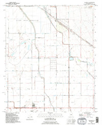 1992 Stanfield1995 Print · USGSThe Pinal County desert and its irrigation-fed fields come alive in the early nineties, centered on the community of Stanfield. Genealogists and historians can trace local landmarks like the Stanfield Sch, the Community Center, and the border of the Ak-Chin Indian Reservation.
 - 1992 Map of Casa Grande East, 1995 Print
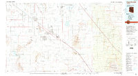
 1992 Casa Grande East1995 Print · USGSMid-century expansion and desert hydrology define this portion of Pinal County in the early nineties. Genealogists and local historians can trace the development of Casa Grande and find landmarks like Central Arizona College and Ironwood Sch.
 - 1992 Map of Casa Grande Mountains, 1995 Print
 1992 Casa Grande Mountains1995 Print · USGSPinal County at the start of the nineties shows a desert landscape transformed by irrigation and rail, from the city of Casa Grande to the Santa Cruz Flats. Researchers can trace early settlements like Arizola and historic sites such as Weaver Pioneer Cemetery and St Anthony Sch.
 - 1992 Map of Valley Farms, 1995 Print
 1992 Valley Farms1995 Print · USGSArizona's Pinal County shows a landscape of complex irrigation and aviation infrastructure in the early 1990s. Researchers can trace the massive Salt Gila Aqueduct, find the Kenilworth Sch, or locate the Coolidge Municipal Airport.
 - 1994 Map of Casa Grande
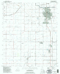
 1994 Casa Grande1994 Print · USGSPinal County in the early nineties shows a desert landscape shaped by massive irrigation projects and ancient heritage. Trace the path of the Southern Pacific past Casa Grande National Monument Ruins and the Silver Reef Mine.3 unique versions available
 - 1994 Map of Mesa
 1994 Mesa1994 Print · USGSThe Phoenix and Mesa metropolitan area meets the desert wilderness in the 1990s as urban growth pushes toward the Superstition Mountains. Researchers can trace the path of the Southern Pacific railroad or locate heritage sites like Casa Grande Ruins Nat Mon and Williams Air Force Base.2 unique versions available
 - 1996 Map of Eloy South, 2001 Print
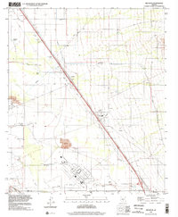
 1996 Eloy South2001 Print · USGSThe Pinal County desert comes into focus in the mid-nineties, showing a landscape defined by industrial agriculture and the Southern Pacific rail line. Trace local history through landmarks like Picacho, the Eloy Memorial Park (Cem), and the Main Canal.
 - 1996 Map of Oracle Junction, 2002 Print
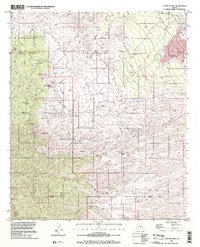
 1996 Oracle Junction2002 Print · USGSOracle Junction and the northern Pima County line are captured in the mid-1990s as the desert landscape transitioned between ranching and growth. Researchers can trace land use through features like the Landing Strip, the Mine Shaft, and the Mobile Home Park.
 - 1996 Map of Rhodes Peak, 2002 Print
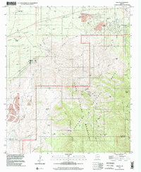
 1996 Rhodes Peak2002 Print · USGSGraham and Pinal Counties in the late 1990s reveal a landscape of high-desert ranching and mining. Trace the remote trails leading to Rhodes Ranch and Mercer Ranch, or locate historical operations like the Magma Mine near Sombrero Butte.
 - 1996 Map of Desert Peak, 2002 Print
 1996 Desert Peak2002 Print · USGSThe Pinal and Pima County line in the mid-1990s shows a desert landscape shaped by mining and water management. Trace early mineral work at the Mine Shaft and Adit, or locate ranching landmarks like the Landing Strip and Corral.
 - 1996 Map of Red Rock, 2002 Print
 1996 Red Rock2002 Print · USGSArizona's Pinal and Pima county line comes alive in the mid-nineties as a critical corridor for aviation and energy. Researchers can trace the massive footprint of the Pinal Airpark and the infrastructure of the Saguaro Power Plant alongside the Santa Cruz River.
 - 1996 Map of Campo Bonito, 2002 Print
 1996 Campo Bonito2002 Print · USGSThe mining camps and cattle ranches of the Santa Catalina foothills are captured here in the mid-1990s. Genealogists and historians can locate family landmarks like the Kannally Ranch or trace the old workings of the Bonito Mine and Southern Belle Mine.
 - 1996 Map of Oak Grove Canyon, 2002 Print
 1996 Oak Grove Canyon2002 Print · USGSThe Pinal and Graham County borderlands come alive in the late twentieth century, showing a landscape defined by deep canyons and high desert peaks. Genealogists and historians can trace the mining legacy of the Galiuro Mountains at the Table Mtn Mine, Lime Camp, and Parsons Grove.
 - 1996 Map of Tortolita Mountains, 2002 Print
 1996 Tortolita Mountains2002 Print · USGSThe Pinal and Pima County line crosses the high desert in the late 1990s, revealing a landscape shaped by mining and water management. Trace early resource use via Ogle Well, Mine Shafts, and remote landmarks like Owl Head Buttes.
 - 1996 Map of Oracle, 2002 Print
 1996 Oracle2002 Print · USGSThe northern foothills of the Santa Catalinas come into focus in the mid-1990s as the high-desert community of Oracle expands. Researchers can locate the local Cem, trace the Mount Lemmon Road, and identify mining activity at the Burney Mines.
 - 1996 Map of North Komelik, 2003 Print
 1996 North Komelik2003 Print · USGSThe Tohono O'odham Reservation in the mid-1990s reveals a desert landscape defined by its mining history and water infrastructure. Researchers can trace historical mining sites like the Orizaba Mine and Jackrabbit Mine or locate the settlement at North Komelik.
 - 1996 Map of Greene Reservoir, 2003 Print
 1996 Greene Reservoir2003 Print · USGSThe Sawtooth Mountains meet the arid valley floor in the 1990s, revealing a landscape defined by desert water management and rugged peaks. Trace the infrastructure of the Greene Canal and the Greene Reservoir Dam (Site), or locate remote landmarks like Wildcat Peak and Laguna.
 - 1996 Map of Kohatk, 2003 Print
 1996 Kohatk2003 Print · USGSThe Tohono O'odham Indian Reservation in the late twentieth century reveals a landscape of desert mining and traditional settlements. Researchers can locate the site of Sif Vaya, trace the Santa Rosa Wash, and identify mining operations like the Christmas Gift Mine and Reward Mine.
 - 1996 Map of Fortified Peak, 2003 Print
 1996 Fortified Peak2003 Print · USGSArizona's high desert terrain in Pinal County is documented here during the late twentieth century, showing a landscape of mining claims and remote ranching. Researchers can locate the Ardmore Mine, isolated dwellings like The Big House, and numerous water catchments including Willow Spring Tank.
Showing maps 1-25 of 38
Top cities of Pinal County
- San Tan Valley historical maps
- Maricopa historical maps
- Casa Grande historical maps
- Apache Junction historical maps
- Florence historical maps
- Eloy historical maps
See more
Frequently asked questions
- What are the different types of historical maps available for Pinal County?
- What is the oldest map of Pinal County?
- Where can I purchase historical maps of Pinal County for my home or office?
- Where can I download high-res historical maps of Pinal County?
- Are there historical topographic maps available for Pinal County?
- Is there historical aerial imagery available for Pinal County?
- Where are historical maps of Pinal County sourced from?