1930s Maps of Pinal County, Arizona
Explore 3 historic maps of Pinal County from the 1930s. These maps offer a rare glimpse into what life looked like during the 1930s — showing old roads, neighborhoods, homes, and landmarks that have changed or disappeared over time.
Whether you're researching your family's past, planning a metal detecting trip, or studying how Pinal County's landscape evolved across the 1930s, these high-resolution maps are a powerful tool for exploring the history of this region.
- Focus on a specific era: All maps on this page are from the 1930s, giving you a focused view of this time period.
- See what’s changed: Compare century-old streets, trails, and buildings to today's modern landscape using overlays and satellite layers.
- Research with precision: Use these maps for genealogy, historical research, land use analysis, or educational projects.
- View, download, or print: Maps are fully viewable online in high resolution, and can be downloaded or printed for your own records.
Start exploring Pinal County's history through authentic maps from the 1930s. This is your window into the past.
Pinal County, AZ maps
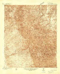
(3)- 1934 Map of Newman Peak
 1934 Newman Peak1934 Print · USGSThe Pinal and Pima County line area is captured here in the mid-1930s, showing a desert landscape shaped by mining and the railroad. Researchers can trace the Southern Pacific line through Redrock or locate the Sasco Mine and 96 Ranch.
 - 1938 Map of Galiuro Mts
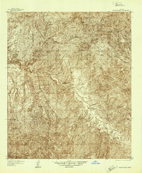
 1938 Galiuro Mts1938 Print · USGSThe high desert of Graham and Pinal Counties comes alive in this pre-war survey of the Galiuro Mountains. Local history researchers can trace old ranching boundaries and mining claims like Sixteen To One Mine, Y L Ranch, and the Gerónimo Camp outpost.5 unique versions available
 - 1938 Map of Klondyke
 1938 Klondyke1938 Print · USGSThe mining and ranching outposts of the Aravaipa Valley are captured here in the late 1930s. Genealogists and historians can trace old homesteads and extraction sites like Landsman Camp, the Grand Reef Mine, and the local Aravaipa Sch near the creek.3 unique versions available
End of results
Showing maps 1-3 of 3
Top cities of Pinal County
- San Tan Valley historical maps
- Maricopa historical maps
- Casa Grande historical maps
- Apache Junction historical maps
- Florence historical maps
- Eloy historical maps
See more
Frequently asked questions
- What are the different types of historical maps available for Pinal County?
- What is the oldest map of Pinal County?
- Where can I purchase historical maps of Pinal County for my home or office?
- Where can I download high-res historical maps of Pinal County?
- Are there historical topographic maps available for Pinal County?
- Is there historical aerial imagery available for Pinal County?
- Where are historical maps of Pinal County sourced from?