1980s Maps of Pinal County, Arizona
Explore 35 historic maps of Pinal County from the 1980s. These maps offer a rare glimpse into what life looked like during the 1980s — showing old roads, neighborhoods, homes, and landmarks that have changed or disappeared over time.
Whether you're researching your family's past, planning a metal detecting trip, or studying how Pinal County's landscape evolved across the 1980s, these high-resolution maps are a powerful tool for exploring the history of this region.
- Focus on a specific era: All maps on this page are from the 1980s, giving you a focused view of this time period.
- See what’s changed: Compare century-old streets, trails, and buildings to today's modern landscape using overlays and satellite layers.
- Research with precision: Use these maps for genealogy, historical research, land use analysis, or educational projects.
- View, download, or print: Maps are fully viewable online in high resolution, and can be downloaded or printed for your own records.
Start exploring Pinal County's history through authentic maps from the 1980s. This is your window into the past.
Pinal County, AZ maps
(35)- 1980 Map of Picacho Pass
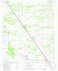
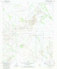
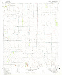
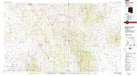
 1980 Picacho Pass1980 Print · USGSThe Pinal County desert comes into focus during the late seventies, showing the critical water and transport networks of this arid corridor. Researchers can trace the path of the Southern Pacific railroad near Picacho Pass and locate the Gold Bell Mine and Clemens settlement.
 - 1980 Map of Red Rock, 1981 Print
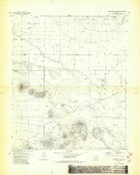
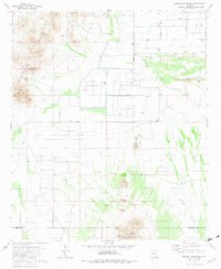
 1980 Red Rock1981 Print · USGSThe Pinal and Pima county line in the early 1980s shows a landscape of desert ranching and industrial growth. Genealogists and historians can trace the Southern Pacific line through Red Rock and the extensive Marana Air Park near Meeks Ranch.2 unique versions available
 - 1981 Map of Vaiva Vo
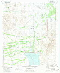 1981 Vaiva Vo1981 Print · USGSWithin the Papago Indian Reservation in the early eighties, this desert landscape showcases the intersection of modern hydrology and traditional settlement. Researchers can trace the massive Tat Momolikot Dam and Lake St Clair alongside local landmarks like Vaiva Vo and nearby Ruins.2 unique versions available
 - 1981 Map of Antelope Peak
 1981 Antelope Peak1981 Print · USGSThe Arizona desert at the start of the 1980s reveals a landscape of high peaks and vast drainage basins along the Maricopa and Pinal county lines. Trace local landmarks like the Hidden Valley Interchange, the heights of Antelope Peak, and an old Corral in the Vekol Valley.2 unique versions available
 - 1981 Map of Phoenix South
 1981 Phoenix South1981 Print · USGSThe desert south of Phoenix in the early eighties shows a unique mix of tribal lands, military outposts, and agricultural growth. Genealogists and historians can trace settlements like Ak Chin and Valencia or locate the Buckeye Copper Mine and Luke Aux Field No 6.2 unique versions available
 - 1981 Map of Silver Reef Mts.
 1981 Silver Reef Mts.1981 Print · USGSThe Silver Reef Mountains of the late 1970s reveal a landscape of desert mining and tribal lands. Researchers can trace historic operations like the Magnesium Queen Mines and Nugget Mine near the settlement of Chuichu.3 unique versions available
 - 1981 Map of Eloy NW
 1981 Eloy NW1981 Print · USGSArizona City and the surrounding Pinal County desert are captured in the early eighties as residential growth met the agricultural basin. Genealogists and historians can trace family-named routes like Alsdorf Road or locate landmarks like Curry Camp and the Lake Towers reservoir.2 unique versions available
 - 1981 Map of Samaniego Hills
 1981 Samaniego Hills1981 Print · USGSThe Arizona desert south of Picacho Peak reveals a landscape of industrial memory and ranching life in the early eighties. Genealogists and historians can locate the Sasco Cem, trace the Old Railroad Grade, and explore the site of the Sasco Ruins.3 unique versions available
 - 1981 Map of Vekol Mts. NE
 1981 Vekol Mts. NE1981 Print · USGSThe Papago Indian Reservation and its desert basins are documented here in the early 1980s. Researchers can trace land use patterns across the Santa Rosa Valley and locate landmarks like the Table Top Mountains and Bitter Well Wash.
 - 1981 Map of Eloy South
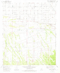
 1981 Eloy South1981 Print · USGSThe agricultural heart of Pinal County is captured here in the early eighties as irrigation transformed the high desert. Genealogists and historians can trace the Southern Pacific rail line, find Eloy Memorial Park (Cem), and locate family-named routes like Pretzer Road and Harmon Road.2 unique versions available
 - 1981 Map of Little Table Top
 1981 Little Table Top1981 Print · USGSThe Papago Indian Reservation and the Vekol Valley are captured here in the early 1980s, showcasing the high desert of Pinal and Maricopa counties. Researchers can trace remote desert outposts and water sources like South Vekol Well, Black Mountain Well, and the seasonal Vekol Wash.
 - 1981 Map of Friendly Corners
 1981 Friendly Corners1981 Print · USGSThe Pinal County desert meets irrigation-fed agriculture in the early eighties at Friendly Corners. Researchers can trace water management and desert infrastructure through the Greene Canal, family-named roads, and landmarks like the Old Well.2 unique versions available
 - 1981 Map of Kohatk
 1981 Kohatk1981 Print · USGSThe Papago Indian Reservation comes into focus during the early 1980s, documenting a landscape of isolated settlements and desert mining. Researchers can locate the community of Kohatk, old Ruins, and historic workings like the Christmas Gift Mine.
 - 1981 Map of Indian Butte
 1981 Indian Butte1981 Print · USGSPinal County in the early eighties was a landscape of sparse desert settlements and mountain peaks. Trace family history or land use through the Papago Indian Reservation and landmarks like Peters Corner or Pinal County West Park.2 unique versions available
 - 1981 Map of Haley Hills
 1981 Haley Hills1981 Print · USGSThe desert landscape of the Pinal and Maricopa county line is captured here in the early eighties. Researchers can trace land use through isolated sites like Poverty Flat Tank, the prominent Papago Butte, and the course of Vekol Wash.
 - 1981 Map of Copperosity Hills
 1981 Copperosity Hills1981 Print · USGSThe Papago Indian Reservation comes into focus during the early eighties, showing a landscape defined by desert mining and ancient habitation. Researchers can trace the heritage of the Kohatk village or locate historic workings like the Vekol Mine and Copperosity Mine.
 - 1981 Map of North Komelik
 1981 North Komelik1981 Print · USGSThe Arizona desert at the Pinal and Pima county line comes into sharp focus in the early 1980s, highlighting the mining and water infrastructure of the region. Researchers can trace historical mining sites like the Lake Shore Mine and the Orizaba Mine near the village of North Komelik.
 - 1981 Map of Newman Peak, 1982 Print
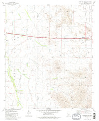
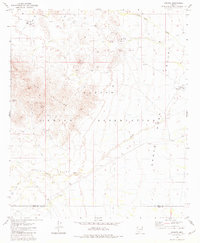
 1981 Newman Peak1982 Print · USGSThe Pinal County desert comes into focus in the early eighties as a critical transport and recreation corridor. Trace the routes through Picacho and Wymola, and locate the Marana Auxiliary Landing Field or the Historical Monuments at Picacho Peak.
 - 1981 Map of Antelope Peak NE, 1982 Print
 1981 Antelope Peak NE1982 Print · USGSAgricultural development and industrial infrastructure dominate this Pinal County landscape in the early eighties. Researchers can trace the layout of the Ak-Chin Indian Reservation and locate local landmarks like the Casa Grande Turbine Station and Peters Corner.2 unique versions available
 - 1981 Map of Greene Reservoir, 1982 Print
 1981 Greene Reservoir1982 Print · USGSThe Pinal and Pima County borderlands appear as a complex network of water management and desert ranching in the early eighties. Researchers can locate the site of the Greene Reservoir Dam (Site), the settlement of Laguna, and landmarks like Wildcat Peak.2 unique versions available
 - 1981 Map of Silver Reef Mts. SE, 1993 Print
 1981 Silver Reef Mts. SE1993 Print · USGSThe high desert of southern Arizona remains largely open in the 1980s, dominated by the Papago Indian Reservation. Researchers can trace old resource sites like the Mine and Prospect or locate water sources including Corral Well.
 - 1981 Map of Gila Bend, 1996 Print
 1981 Gila Bend1996 Print · USGSSouthern Arizona in the early eighties reveals a vast desert corridor shaped by military ranges, indigenous lands, and historical mining. Genealogists and historians can trace rail-side settlements like Theba and Piedra or locate the historic Vekol Mine and Reward Mine.
 - 1982 Map of Ajo
 1982 Ajo1982 Print · USGSThe Arizona-Sonora borderlands come into focus in the early eighties, showcasing a landscape of desert mining towns and expansive tribal lands. Trace the Southern Pacific rail line through Gila Bend or explore the remote settlements of Ajo and Lukeville.
 - 1986 Map of Globe
 1986 Globe1986 Print · USGSThe copper districts of Gila County and the lands of the San Carlos Apache are detailed here during the mid-eighties. Researchers can trace the industrial footprint of the Miami Mine, the sprawling San Carlos Reservoir, and small riverside settlements like Bylas and Geronimo.2 unique versions available
 - 1986 Map of Mammoth, 1987 Print
 1986 Mammoth1987 Print · USGSThe copper-rich corridors of Pinal and Graham counties are captured in the mid-1980s as mining towns and mountain wilderness met. Researchers can trace the industrial footprints of the San Manuel Mine and Hayden, alongside landmarks like the Silver Queen Mine and Aravaipa Creek.3 unique versions available
Showing maps 1-25 of 35
Top cities of Pinal County
- San Tan Valley historical maps
- Maricopa historical maps
- Casa Grande historical maps
- Apache Junction historical maps
- Florence historical maps
- Eloy historical maps
See more
Frequently asked questions
- What are the different types of historical maps available for Pinal County?
- What is the oldest map of Pinal County?
- Where can I purchase historical maps of Pinal County for my home or office?
- Where can I download high-res historical maps of Pinal County?
- Are there historical topographic maps available for Pinal County?
- Is there historical aerial imagery available for Pinal County?
- Where are historical maps of Pinal County sourced from?