1970s Maps of Mendocino County, California
Explore 7 historic maps of Mendocino County from the 1970s. These maps offer a rare glimpse into what life looked like during the 1970s — showing old roads, neighborhoods, homes, and landmarks that have changed or disappeared over time.
Whether you're researching your family's past, planning a metal detecting trip, or studying how Mendocino County's landscape evolved across the 1970s, these high-resolution maps are a powerful tool for exploring the history of this region.
- Focus on a specific era: All maps on this page are from the 1970s, giving you a focused view of this time period.
- See what’s changed: Compare century-old streets, trails, and buildings to today's modern landscape using overlays and satellite layers.
- Research with precision: Use these maps for genealogy, historical research, land use analysis, or educational projects.
- View, download, or print: Maps are fully viewable online in high resolution, and can be downloaded or printed for your own records.
Start exploring Mendocino County's history through authentic maps from the 1970s. This is your window into the past.
Mendocino County, CA maps
(7)- 1970 Map of Hales Grove, 1974 Print
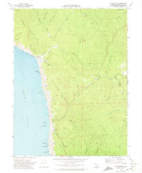 1970 Hales Grove1974 Print · USGSCoastal Mendocino County reveals its remote ranching and timber heritage during the 1970s, from the steep ridges of the interior to the rocky Pacific shoreline. Researchers can trace the layout of Hales Grove, find the DeVilbiss Ranch, and explore old routes like Usal Road.2 unique versions available
 - 1970 Map of Garberville, 1974 Print
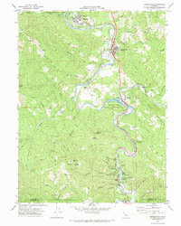 1970 Garberville1974 Print · USGSCoastal canyon life along the South Fork Eel River is captured here during the 1970s. Local researchers can trace family landmarks and rural holdings from Boyer Ranch and Pauli Ranch to the early resort grounds of Benbow.
 - 1972 Map of Healdsburg, 1975 Print
 1972 Healdsburg1975 Print · USGSNorthern California wine country and the lower Lake County basins appear here during the early seventies. Trace the Northwestern Pacific rail line and discover foothill communities like Middletown and Loch Lomond.2 unique versions available
 - 1977 Map of Gualala, 1978 Print
 1977 Gualala1978 Print · USGSThe Mendocino coast in the late seventies reveals a landscape of timber mills and maritime landings. Trace family roots at Bourn Cem and Seaside Sch, or explore the old sites of Anchor Bay and Gualala.
 - 1977 Map of Highland Springs, 1979 Print
 1977 Highland Springs1979 Print · USGSLake County landscapes are captured in detail during the late seventies through high-resolution aerial photography. Genealogists and environmental historians can trace the precise natural course of Adobe Creek and study the historic agricultural footprints of the region.2 unique versions available
 - 1977 Map of Upper Lake, 1980 Print
 1977 Upper Lake1980 Print · USGSUpper Lake and the surrounding valley are captured in high-altitude detail during the late seventies, showing the region's agricultural footprint. Trace the path of Middle Creek through the orchards of Bachelor Valley toward the base of White Rock Mtn.
 - 1979 Map of Garberville, 1996 Print
 1979 Garberville1996 Print · USGSThe redwood forests and river canyons of Humboldt and Trinity counties are shown here in the late seventies. Genealogists and historians can trace rail-side life along the Northwestern Pacific RR or locate small settlements like Fort Seward, Alderpoint, and Zenia.
End of results
Showing maps 1-7 of 7
Top cities of Mendocino County
- Ukiah historical maps
- Fort Bragg historical maps
- Willits historical maps
- Redwood Valley historical maps
- Talmage historical maps
- Talmage historical maps
See more
Frequently asked questions
- What are the different types of historical maps available for Mendocino County?
- What is the oldest map of Mendocino County?
- Where can I purchase historical maps of Mendocino County for my home or office?
- Where can I download high-res historical maps of Mendocino County?
- Are there historical topographic maps available for Mendocino County?
- Is there historical aerial imagery available for Mendocino County?
- Where are historical maps of Mendocino County sourced from?