1960s Maps of Mendocino County, California
Explore 62 historic maps of Mendocino County from the 1960s. These maps offer a rare glimpse into what life looked like during the 1960s — showing old roads, neighborhoods, homes, and landmarks that have changed or disappeared over time.
Whether you're researching your family's past, planning a metal detecting trip, or studying how Mendocino County's landscape evolved across the 1960s, these high-resolution maps are a powerful tool for exploring the history of this region.
- Focus on a specific era: All maps on this page are from the 1960s, giving you a focused view of this time period.
- See what’s changed: Compare century-old streets, trails, and buildings to today's modern landscape using overlays and satellite layers.
- Research with precision: Use these maps for genealogy, historical research, land use analysis, or educational projects.
- View, download, or print: Maps are fully viewable online in high resolution, and can be downloaded or printed for your own records.
Start exploring Mendocino County's history through authentic maps from the 1960s. This is your window into the past.
Mendocino County, CA maps
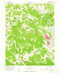
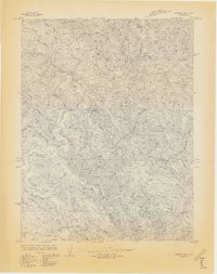
(62)- 1960 Map of Ukiah
 1960 Ukiah1960 Print · USGSNorthern California during the late fifties reveals a landscape of deep timber forests and valley agriculture before modern expansion. Trace the historic rail lines of the California Western RR and the Northwestern Pacific RR through settlements like Fort Bragg and Ukiah.2 unique versions available
 - 1960 Map of Saunders Reef, 1961 Print
 1960 Saunders Reef1961 Print · USGSThe Mendocino coast in the early sixties is captured here as a working landscape of timber and tide. Researchers can locate the Lumber Mill at Hearn Gulch, the old Galloway Sch, and the historical maritime sites at Saunders Landing.3 unique versions available
 - 1960 Map of Gualala, 1961 Print
 1960 Gualala1961 Print · USGSThe Mendocino coast in the early sixties reveals a landscape of timber mills and maritime landings. Researchers can trace the legacy of early families and industry at Bourns Cem, the Seaside Sch, and the Lumber Mill near the Gualala River.3 unique versions available
 - 1960 Map of Potter Valley, 1961 Print
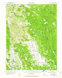
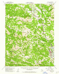
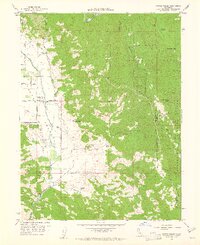 1960 Potter Valley1961 Print · USGSPotter Valley at the start of the 1960s was a thriving agricultural basin defined by its sophisticated water canals and family ranches. Researchers can locate the Pomo (Site), the Potter Valley Cem, and diverse mountain landmarks like Garrett Mtn Lookout.2 unique versions available
 - 1960 Map of Elk, 1962 Print
 1960 Elk1962 Print · USGSThe Mendocino coast in the early sixties is captured here as a landscape of timber ridges and Pacific headlands. Genealogists and historians can trace the settlements of Elk and Brown or locate specific landmarks like Cuffeys Point and the Airstrip.3 unique versions available
 - 1960 Map of Cloverdale, 1962 Print
 1960 Cloverdale1962 Print · USGSCloverdale and the Russian River valley are captured in the early sixties as the regional rail and road networks shaped northern Sonoma County. Genealogists and local historians can trace family-named sites like Porterfield, the Cloverdale Rancheria, and the Cemetery at Preston.4 unique versions available
 - 1960 Map of Point Arena, 1962 Print
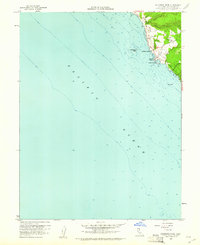
 1960 Point Arena1962 Print · USGSThe Mendocino coast in the early 1960s shows a landscape of maritime tradition and Cold War defense. Researchers can trace family history through the Manchester (Point Arena) Rancheria, find local landmarks like Point Arena Lighthouse, and locate smaller settlements such as Flumeville.2 unique versions available
 - 1960 Map of Potter Valley, 1962 Print
 1960 Potter Valley1962 Print · USGSMendocino County's agricultural and river landscapes are captured here during the early sixties, showing the vital connections between the Eel and Russian River watersheds. Genealogists and local historians can trace family roots through the Potter Valley Rancheria, the Potter Valley Cem, and old settlements like Hearst and Pomo.2 unique versions available
 - 1960 Map of Point Arena, 1962 Print
 1960 Point Arena1962 Print · USGSThe Mendocino coast comes into sharp focus during the early 1960s, showing the intersection of maritime navigation and rural settlement. Researchers can trace the grounds of the Lighthouse and Coast Guard Reservation or locate family sites near Manchester and Flumeville.5 unique versions available
 - 1960 Map of Albion, 1962 Print
 1960 Albion1962 Print · USGSThe Mendocino coast in the early sixties is captured here at the height of its mid-century character. Genealogists and local historians can trace the Whitesboro settlement site and family-named landmarks like McPherson and Handley.3 unique versions available
 - 1960 Map of Ornbaun Valley, 1962 Print
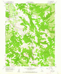
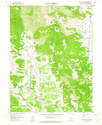
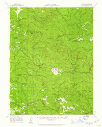
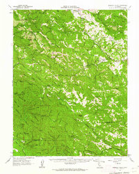 1960 Ornbaun Valley1962 Print · USGSThe rugged interior of Mendocino County during the early 1960s is defined by vast ranch holdings and steep river canyons. Genealogists and historians can trace family locations at Mailliard Ranch, find the Ornbaun Sprs Cem, and locate the Gualala Mtn Lookout.2 unique versions available
 - 1960 Map of Fort Bragg, 1962 Print
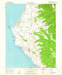
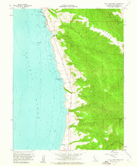
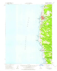
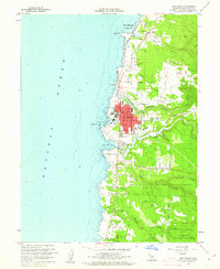 1960 Fort Bragg1962 Print · USGSThe Mendocino coast is shown at a peak of its mid-century industrial and timber era, centered on the bustling hub of Fort Bragg. Researchers can trace the path of the California Western RR or locate coastal landmarks like Lake Cleone and the Noyo waterfront.5 unique versions available
 - 1960 Map of Hopland, 1962 Print
 1960 Hopland1962 Print · USGSThe Russian River corridor in Mendocino County is documented here at the start of the 1960s. Researchers can trace the dual centers of Hopland and Old Hopland, locate the Hopland Cemetery, and follow the Northwestern Pacific rail line through the valley.3 unique versions available
 - 1960 Map of Mallo Pass Creek, 1962 Print
 1960 Mallo Pass Creek1962 Print · USGSThe Mendocino coast in the early sixties reveals a landscape of deep gulches and isolated landings. Trace the early settlement patterns at Bridgeport Landing and follow the remote paths of Mallo Pass Creek and Irish Gulch.3 unique versions available
 - 1960 Map of Hopland, 1962 Print
 1960 Hopland1962 Print · USGSMendocino and Sonoma counties meet in this early 1960s survey of the Russian River valley as it transitions into the coastal range. Researchers can trace the rail-and-road corridor through Old Hopland, locate the Cloverdale Rancheria, and find historical sites like the Squaw Rock Slide Historical Marker.2 unique versions available
 - 1960 Map of Mendocino, 1962 Print
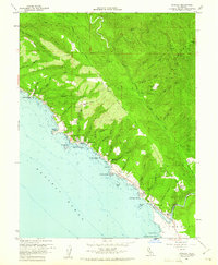
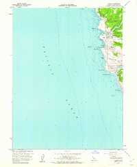
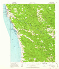
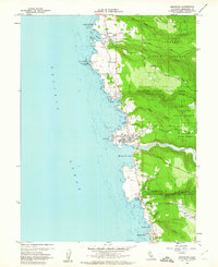 1960 Mendocino1962 Print · USGSCoastal Mendocino County is seen here in the early sixties, a time when seaside towns and timberlands met at the Pacific shore. Researchers can trace local lineage at Hillcrest Cem or find maritime landmarks like the Point Cabrillo Light Station.3 unique versions available
 - 1960 Map of Redwood Valley, 1962 Print
 1960 Redwood Valley1962 Print · USGSThe Russian River valley in the early sixties shows a landscape of steady growth along the Northwestern Pacific railroad. Researchers can trace the boundaries of the Potter Valley Rancheria, locate the old Cem, and explore water systems like the Powerhouse Canal.3 unique versions available
 - 1960 Map of Comptche, 1962 Print
 1960 Comptche1962 Print · USGSCoastal Mendocino County is seen here in the early sixties, dominated by the timber lands of the Jackson State Forest. Genealogists and historians can trace rail-line settlements like Irmulco and Northspur along the California Western Railroad.2 unique versions available
 - 1960 Map of Fort Bragg, 1963 Print
 1960 Fort Bragg1963 Print · USGSThe Mendocino coast in the early sixties remains a hub for timber and coastal trade before its full modern tourism expansion. Trace the California Western railroad line or locate historical maritime landmarks like the Point Cabrillo Light Station and Caspar Anchorage.2 unique versions available
 - 1961 Map of Eureka
 1961 Eureka1961 Print · USGSThe Northern California coast and its deep redwood forests are mapped here at a time when the timber and rail industries defined the region. Researchers can trace historic family ranches and remote sites like Fort Dick, Table Bluff Lighthouse, and the Copper Creek Mine.2 unique versions available
 - 1961 Map of Navarro, 1962 Print
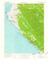
 1961 Navarro1962 Print · USGSThe Mendocino coast in the early sixties reveals a landscape of timber history and coastal villages. Trace the former shipping sites at Whitesboro and Bridgeport Landing or the winding path of the Albion Railroad.2 unique versions available
 - 1961 Map of Willits, 1963 Print
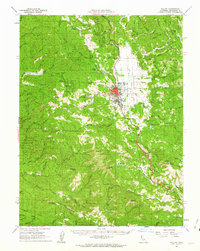 1961 Willits1963 Print · USGSMendocino County's timber and rail corridor comes into focus in the early sixties, centered on the transport hub of Willits. Researchers can trace the routes of the California Western and locate family landmarks such as the Little Lake Cem and Brooktrails Ranch.3 unique versions available
 - 1962 Map of Santa Rosa
 1962 Santa Rosa1962 Print · USGSThe North Bay and Wine Country were entering a period of significant growth in the early sixties, anchored by established rail corridors and coastal maritime commerce. Genealogists and historians can trace the development of Santa Rosa, locate the Mare Island Naval Shipyard, and follow the Northwestern Pacific RR through the Cotati Valley.
 - 1964 Map of Santa Rosa
 1964 Santa Rosa1964 Print · USGSThe North Bay and Wine Country appear in the mid-fifties during a period of significant military and educational growth. Trace old rail lines like the Northwestern Pacific RR and explore historic sites from Petaluma to the Benicia Arsenal.
 - 1966 Map of Dutchmans Knoll
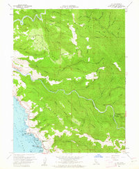
 1966 Dutchmans Knoll1966 Print · USGSMendocino County's coastal timberlands are captured here in the mid-1960s, showing a landscape defined by private roads and river drainages. You can trace early land use through features like O'Conner Orchard, the Gaging Station, and Dutchmans Knoll.3 unique versions available
Showing maps 1-25 of 62
Top cities of Mendocino County
- Ukiah historical maps
- Fort Bragg historical maps
- Willits historical maps
- Redwood Valley historical maps
- Talmage historical maps
- Talmage historical maps
See more
Frequently asked questions
- What are the different types of historical maps available for Mendocino County?
- What is the oldest map of Mendocino County?
- Where can I purchase historical maps of Mendocino County for my home or office?
- Where can I download high-res historical maps of Mendocino County?
- Are there historical topographic maps available for Mendocino County?
- Is there historical aerial imagery available for Mendocino County?
- Where are historical maps of Mendocino County sourced from?