1950s Maps of Siskiyou County, California
Explore 53 historic maps of Siskiyou County from the 1950s. These maps offer a rare glimpse into what life looked like during the 1950s — showing old roads, neighborhoods, homes, and landmarks that have changed or disappeared over time.
Whether you're researching your family's past, planning a metal detecting trip, or studying how Siskiyou County's landscape evolved across the 1950s, these high-resolution maps are a powerful tool for exploring the history of this region.
- Focus on a specific era: All maps on this page are from the 1950s, giving you a focused view of this time period.
- See what’s changed: Compare century-old streets, trails, and buildings to today's modern landscape using overlays and satellite layers.
- Research with precision: Use these maps for genealogy, historical research, land use analysis, or educational projects.
- View, download, or print: Maps are fully viewable online in high resolution, and can be downloaded or printed for your own records.
Start exploring Siskiyou County's history through authentic maps from the 1950s. This is your window into the past.
Siskiyou County, CA maps
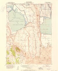
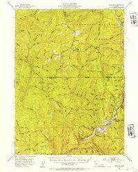
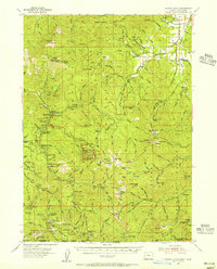
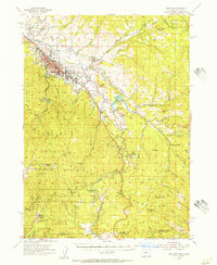
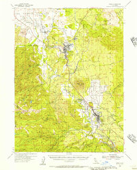
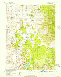
(53)- 1950 Map of Weed
 1950 Weed1950 Print · USGSSiskiyou County and the surrounding Klamath mountains appear in the mid-century before extensive modern development. Genealogists and local historians can locate remote outposts like the Lee Brown Ranch and the specialized settlement of Darlingtonia.
 - 1950 Map of Mt. Dome, 1952 Print
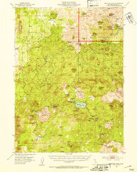
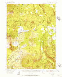
 1950 Mt. Dome1952 Print · USGSUpper Klamath Basin life in the mid-century shows a landscape of reclamation and deep history at the Oregon-California border. Trace early ranching and water management at Chalk Bank Landing, the Winema Sch, and the Tulelake Tunnel.4 unique versions available
 - 1950 Map of Bray, 1952 Print
 1950 Bray1952 Print · USGSSiskiyou County's timber and rail corridor comes to life in the early fifties, showing the logging networks surrounding Tennant and Bray. Researchers can trace the path of the Lumber RR and locate remote sites like Ice Cave or the Cem near the forest boundary.10 unique versions available
 - 1950 Map of Dorris, 1952 Print
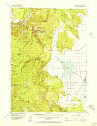
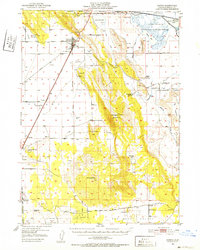 1950 Dorris1952 Print · USGSIn this mid-century portrait of the Siskiyou high country, the town of Dorris stands at the intersection of rail and ranching. Researchers can trace family history at the Picard Cem, locate rural schoolhouses like Oklahoma Sch, or explore the historic wetlands of the Lower Klamath Lake.4 unique versions available
 - 1950 Map of Minersville, 1952 Print
 1950 Minersville1952 Print · USGSTrinity County's high country and early settlements are captured here in the early 1950s, just before the landscape was transformed by reservoir construction. Genealogists and historians can locate Old Minersville, Ridgeville (Site), and remote mountain locations like Bricks Ranch.4 unique versions available
 - 1951 Map of Tulelake, 1953 Print
 1951 Tulelake1953 Print · USGSTule Lake and the Modoc plateau are captured in the early fifties during the height of the region's agricultural development. Genealogists and historians can trace the legacy of family ranching at Old Elliot Ranch or locate the historic Battle of Lands Ranch (Site) and Carr School.4 unique versions available
 - 1952 Map of Orleans, 1954 Print
 1952 Orleans1954 Print · USGSThe Klamath River corridor near the tri-county border appears here in the early fifties, showing a landscape of forest service outposts and family ranching. Researchers can locate the Reece Homestead, the Hunter Little Ranch, and historical mining sites like the Owl Mine.3 unique versions available
 - 1952 Map of Timber Mountain, 1954 Print
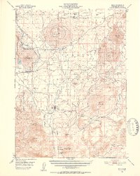
 1952 Timber Mountain1954 Print · USGSThe Modoc high country in the early fifties shows a rugged landscape of volcanic flows and forest industry. You can trace the Modoc War history at Captain Jacks Stronghold or locate logging era sites like Old Camp One and the Tionesta PO.5 unique versions available
 - 1952 Map of Medicine Lake, 1954 Print
 1952 Medicine Lake1954 Print · USGSSiskiyou County's volcanic highlands are captured here in the early 1950s, a landscape defined by massive obsidian flows and the Lava Beds National Monument. Researchers can trace old forestry and mining sites like Underlakers Camp, the Pumice Mine, and remote stations at Telephone Flat.4 unique versions available
 - 1954 Map of Cave Junction, 1956 Print
 1954 Cave Junction1956 Print · USGSThe Illinois River valley in Southern Oregon comes alive in the mid-fifties, showing a landscape of mining camps and timber towns before modern development. Researchers can trace family sites at Takilma, locate the old Waldo townsite, or find historic workings like the Esterly Mine.3 unique versions available
 - 1954 Map of Oregon Caves, 1956 Print
 1954 Oregon Caves1956 Print · USGSThe Siskiyou Mountains come alive in the mid-1950s, showing a landscape defined by high-altitude mining and the early infrastructure of Oregon Caves National Monument. Genealogists and historians can trace old homesteads and mining sites like Browntown, Watts Cem, and Tiger Springs California Bar.3 unique versions available
 - 1954 Map of The Whaleback, 1956 Print
 1954 The Whaleback1956 Print · USGSThe timbered uplands of Siskiyou County are mapped here in the mid-fifties as the logging industry and rail network reached their peak. Researchers can trace the Southern Pacific line past Leaf and Andesite or locate the historic Soule Ranch.3 unique versions available
 - 1954 Map of Macdoel, 1956 Print
 1954 Macdoel1956 Print · USGSSiskiyou County ranching and rail history converge in the mid-1950s as the Klamath River meets the Shasta Valley. Genealogists and historians can trace family land at the Meiss Ranch, locate the Oak Grove Sch (Aban'd), or follow the Southern Pacific tracks through Macdoel.3 unique versions available
 - 1954 Map of Talent, 1956 Print
 1954 Talent1956 Print · USGSSiskiyou and Rogue River national forests meet here in the mid-fifties, where the Rogue River Valley's agricultural reach hits the high mountains. Genealogists and researchers can locate the Steam Cem, the settlement of Buncom, and old high-country sites like Freezeout Cabin.3 unique versions available
 - 1954 Map of Ashland, 1956 Print
 1954 Ashland1956 Print · USGSThe Rogue River Valley is captured here in the mid-fifties, centered on the growth of Ashland and its mountain passes. Genealogists and historians can trace the Southern Pacific RR through settlements like Colestin, Mistletoe, and Stienman.3 unique versions available
 - 1954 Map of Copco, 1956 Print
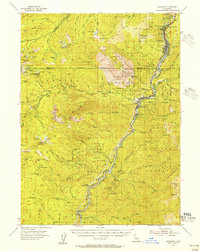
 1954 Copco1956 Print · USGSSiskiyou County during the mid-fifties is captured here as the Klamath River corridor transitions from mountain forest to the Shasta Valley. Researchers can locate the Southern Pacific railroad line, the remote Fall Creek Sch, and the reservoir at Copco Lake.2 unique versions available
 - 1954 Map of Shoeinhorse Mountain, 1956 Print
 1954 Shoeinhorse Mountain1956 Print · USGSThe McCloud River canyon in the mid-fifties is a landscape of timber camps and remote retreats. Genealogists and historians can trace the sites of Wyntoon, Fowler Camp, and the Logging Camp alongside landmarks like Shoeinhorse Mtn.3 unique versions available
 - 1954 Map of Shasta, 1956 Print
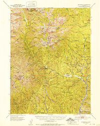
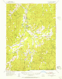
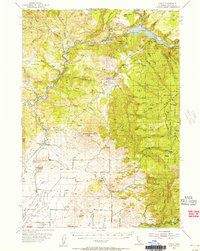
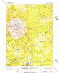 1954 Shasta1956 Print · USGSSiskiyou County at the height of the mid-century timber era showcases the towering ice-capped peaks and the bustling mill town of McCloud. Trace the routes of the Mc Cloud River RR and locate historic backcountry sites like Shasta Alpine Lodge and Wagon Camp.8 unique versions available
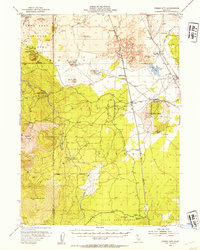
 - 1954 Map of Weed, 1956 Print
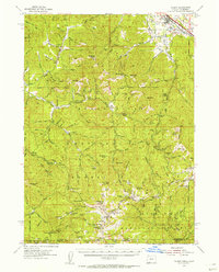
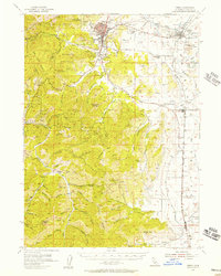
 1954 Weed1956 Print · USGSMount Shasta and its surrounding timber towns come alive in this mid-century survey of Siskiyou County. Researchers can trace the path of the Southern Pacific through Weed and Edgewood, or locate specific landmarks like the Fish Hatchery and Mott.3 unique versions available
 - 1954 Map of Ruch, 1956 Print
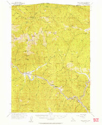
 1954 Ruch1956 Print · USGSThe foothills of the Siskiyous in the 1950s show a landscape of active mining and forest management. Researchers can trace historic mineral claims like the Layton Mine or find early recreational and administrative sites like McKee Bridge Camp and Star Ranger Station.3 unique versions available
 - 1954 Map of Dunsmuir, 1957 Print
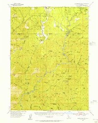
 1954 Dunsmuir1957 Print · USGSThe Sacramento River canyon in the 1950s was a critical transit corridor where the rail and road network shaped mountain life. Genealogists and historians can trace the canyon floor communities of Dunsmuir, Castella, and Shasta Retreat, or find remote landmarks like Whalan Station and Castle Rock Sch.4 unique versions available
 - 1954 Map of Yreka, 1957 Print
 1954 Yreka1957 Print · USGSSiskiyou County during the mid-fifties is captured here as a landscape of established cattle ranching and mining tradition. Genealogists and historians can trace old homesteads and landmarks like Forest House, local schools such as Delphic School, and workings at the Pegleg Mine.3 unique versions available
 - 1954 Map of Dwinnell Reservoir, 1957 Print
 1954 Dwinnell Reservoir1957 Print · USGSSiskiyou County's volcanic and agricultural heart comes into focus during the mid-fifties, just as infrastructure like the Dwinnell Reservoir stabilized the local water supply. Genealogists and historians can trace family locations near the Little Shasta Cem, Hovey Gulch School, and the early settlement of Four Corners.4 unique versions available
 - 1954 Map of Alturas, 1968 Print
 1954 Alturas1968 Print · USGSThe Modoc Plateau and Surprise Valley appear in the mid-1950s as a landscape of remote ranching towns and vast wildlife refuges. Researchers can trace early settlements like Fort Bidwell, locate the McArthur Grain Elevator, and follow the Southern Pacific rail lines.4 unique versions available
 - 1955 Map of Seiad Valley, 1957 Print
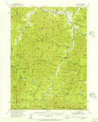
 1955 Seiad Valley1957 Print · USGSSiskiyou County's Klamath River corridor is captured here in the mid-fifties, showing the isolated mining and ranching settlements along the Oregon border. Genealogists and researchers can trace the roads to Seiad Valley, Hamburg, and the remote Blue Ledge Mine.3 unique versions available
Showing maps 1-25 of 53
Top cities of Siskiyou County
- Yreka historical maps
- Mount Shasta historical maps
- Weed historical maps
- Dunsmuir historical maps
- Montague historical maps
- Tulelake historical maps
See more
Frequently asked questions
- What are the different types of historical maps available for Siskiyou County?
- What is the oldest map of Siskiyou County?
- Where can I purchase historical maps of Siskiyou County for my home or office?
- Where can I download high-res historical maps of Siskiyou County?
- Are there historical topographic maps available for Siskiyou County?
- Is there historical aerial imagery available for Siskiyou County?
- Where are historical maps of Siskiyou County sourced from?