1960s Maps of Siskiyou County, California
Explore 11 historic maps of Siskiyou County from the 1960s. These maps offer a rare glimpse into what life looked like during the 1960s — showing old roads, neighborhoods, homes, and landmarks that have changed or disappeared over time.
Whether you're researching your family's past, planning a metal detecting trip, or studying how Siskiyou County's landscape evolved across the 1960s, these high-resolution maps are a powerful tool for exploring the history of this region.
- Focus on a specific era: All maps on this page are from the 1960s, giving you a focused view of this time period.
- See what’s changed: Compare century-old streets, trails, and buildings to today's modern landscape using overlays and satellite layers.
- Research with precision: Use these maps for genealogy, historical research, land use analysis, or educational projects.
- View, download, or print: Maps are fully viewable online in high resolution, and can be downloaded or printed for your own records.
Start exploring Siskiyou County's history through authentic maps from the 1960s. This is your window into the past.
Siskiyou County, CA maps
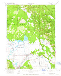
(11)- 1961 Map of Hambone, 1963 Print
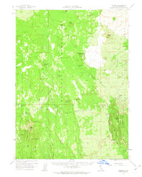 1961 Hambone1963 Print · USGSSiskiyou County's timber and rail history is preserved here as it appeared in the early sixties, centered on the logging crossroads of Hambone. Researchers can trace the Great Northern tracks and family-named sites like the Wiley Ranch Guard Station and Julia Glover Flat.2 unique versions available
 - 1961 Map of Pondosa, 1963 Print
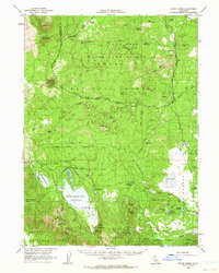
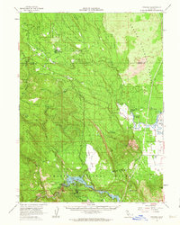 1961 Pondosa1963 Print · USGSShasta County timber and water resources are in focus during the early sixties, as logging roads and rail grades weave through the Cascades. Genealogists and researchers can locate the Dana Cem, the old settlement of Pondosa, and the grounds of Mc Arthur-Burney Falls Memorial State Park.2 unique versions available
 - 1961 Map of Big Bend, 1963 Print
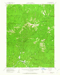 1961 Big Bend1963 Print · USGSShasta County forest and river life are captured here in the early sixties, centered on the Pit River canyon. Local history researchers can trace the Big Bend Rancheria, locate the Indian Spr Sch, and follow the path of the McCloud River Railroad through the timber.2 unique versions available
 - 1961 Map of Bartle, 1963 Print
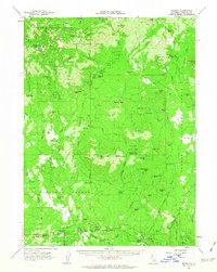 1961 Bartle1963 Print · USGSSiskiyou County logging and forestry operations reached their mid-century peak as the Mc Cloud River RR connected the timber camps of Bartle and Algoma. Researchers can trace the heritage of the lumber industry through sites like the Mt Shasta Nursery, the Swobe settlement, and various old RR grades.2 unique versions available
 - 1961 Map of Fall River Mills, 1963 Print
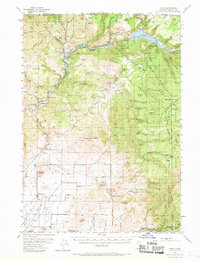
 1961 Fall River Mills1963 Print · USGSNortheastern California at the dawn of the 1960s reveals a unique landscape of volcanic lava beds and extensive river irrigation. Researchers can trace family history at Pine Grove Cemetery and Island School, or explore the complex waterways of Big Lake and the Fall River.2 unique versions available
 - 1962 Map of Alturas
 1962 Alturas1962 Print · USGSThe high desert of Modoc and Siskiyou counties is shown in the early sixties as a hub of timber, rail, and agriculture. Genealogists and historians can trace rail-side life via the Southern Pacific RR, the Tionesta PO, and the McArthur Grain Elevator.
 - 1962 Map of White Horse, 1964 Print
 1962 White Horse1964 Print · USGSThe Modoc plateau in the early sixties is a land of volcanic rims and isolated timber outposts. Researchers can trace the water sources and ranching history at White Horse, Long Bell Station, and the remote McArthur Cow Camp.2 unique versions available
 - 1962 Map of Copco, 1970 Print
 1962 Copco1970 Print · USGSSiskiyou County's high country and the Klamath River basin appear here in the early sixties as a landscape of hydroelectric progress and mountain ranching. Genealogists and historians can locate rural landmarks like Ager, the Willow Creek School, and the tracks of the Southern Pacific Railroad.
 - 1963 Map of Weed
 1963 Weed1963 Print · USGSNorthern California during the early 1960s shows a landscape of steep mountain ranges and river-fed valleys at the height of the timber era. Researchers can trace the routes of the McCloud River RR, locate remote sites like the Holiday Mine, or find ancestral markers at the Scott Valley Cem.
 - 1965 Map of Alturas
 1965 Alturas1965 Print · USGSNortheastern California and southern Oregon appear in this mid-century survey of the high plateau and volcanic highlands. Researchers can trace the path of the Southern Pacific railroad through Alturas or locate rural outposts like Stronghold and Eagleville.
 - 1969 Map of Bonanza King, 1971 Print
 1969 Bonanza King1971 Print · USGSThe Trinity Alps region at the end of the 1960s shows a landscape of historic mining claims and new recreation areas. Researchers can trace the heritage of the Bonanza King Mine or locate the site of Carrville near the shores of Clair Engle Lake.
End of results
Showing maps 1-11 of 11
Top cities of Siskiyou County
- Yreka historical maps
- Mount Shasta historical maps
- Weed historical maps
- Dunsmuir historical maps
- Montague historical maps
- Tulelake historical maps
See more
Frequently asked questions
- What are the different types of historical maps available for Siskiyou County?
- What is the oldest map of Siskiyou County?
- Where can I purchase historical maps of Siskiyou County for my home or office?
- Where can I download high-res historical maps of Siskiyou County?
- Are there historical topographic maps available for Siskiyou County?
- Is there historical aerial imagery available for Siskiyou County?
- Where are historical maps of Siskiyou County sourced from?