1920s Maps of Trinity County, California
Explore 8 historic maps of Trinity County from the 1920s. These maps offer a rare glimpse into what life looked like during the 1920s — showing old roads, neighborhoods, homes, and landmarks that have changed or disappeared over time.
Whether you're researching your family's past, planning a metal detecting trip, or studying how Trinity County's landscape evolved across the 1920s, these high-resolution maps are a powerful tool for exploring the history of this region.
- Focus on a specific era: All maps on this page are from the 1920s, giving you a focused view of this time period.
- See what’s changed: Compare century-old streets, trails, and buildings to today's modern landscape using overlays and satellite layers.
- Research with precision: Use these maps for genealogy, historical research, land use analysis, or educational projects.
- View, download, or print: Maps are fully viewable online in high resolution, and can be downloaded or printed for your own records.
Start exploring Trinity County's history through authentic maps from the 1920s. This is your window into the past.
Trinity County, CA maps
(8)- 1920 Map of Cummings
 1920 Cummings1920 Print · USGSMendocino County ranching and transit corridors are captured in the years following the Great War as the modern highway began to take shape. Genealogists and historians can locate family holdings like Buckhorn Ranch and Spittler Ranch alongside early settlements at Bell Springs and Cummings.
 - 1920 Map of Covelo
 1920 Covelo1920 Print · USGSTracing the Eel River in the early twentieth century, this military survey reveals the remote homesteads and rail infrastructure of Mendocino County. Genealogists can locate family-named sites like Fred Simmerly Sr and Nash along the Northwestern Pacific Railroad.
 - 1920 Map of Harris
 1920 Harris1920 Print · USGSHumboldt County ranching and rail life are recorded here during the early twentieth century as the railroad carved its path through the Eel River canyon. Researchers can trace historic family holdings like Carey Ranch or locate early industrial sites such as the Steelhead US Fish Hatchery and Fort Seward.
 - 1921 Map of Hoaglin, 1922 Print
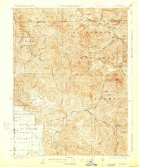
 1921 Hoaglin1922 Print · USGSTrinity County in the early twenties shows a wilderness being mapped for forest management and rail access. Genealogists and researchers can trace early ranger outposts like Soldier Basin R.s. and follow the Northwestern Pacific RR near Island Mountain.
 - 1922 Map of Island Mountain
 1922 Island Mountain1922 Print · USGSNorthern California forest lands and river canyons are detailed in this early twenties tactical survey. Genealogists and researchers can locate remote outposts like Zenia and Hoaglin, or trace the rugged banks of the Mad River and Eel River.
 - 1922 Map of China Flat
 1922 China Flat1922 Print · USGSNorthwestern California at the dawn of the 1920s reveals a landscape of isolated river settlements and early forest service outposts. Genealogists and historians can trace the residents of Quinby and Uptons or locate the China Flat Post Office and Handy Horse Ranger Station.
 - 1923 Map of Sawyers Bar
 1923 Sawyers Bar1923 Print · USGSThe Salmon River canyon in the early 1900s reveals a high-country mining landscape during the height of its activity. Genealogists and historians can trace families at Edie Ranch, locate remote classrooms like Russianville School, and find numerous prospects including the Black Bear Mine.4 unique versions available
 - 1926 Map of Covelo
 1926 Covelo1926 Print · USGSThe isolated high valley of Covelo is captured here in the mid-1920s, surrounded by the wilderness of the California National Forest. Local historians can locate the Indian School, early ranger outposts, and family landmarks like Browns Ranch.2 unique versions available
End of results
Showing maps 1-8 of 8
Top cities of Trinity County
- Weaverville historical maps
- Hayfork historical maps
- Lewiston historical maps
- Trinity Village historical maps
- Ruth historical maps
- Zenia historical maps
Frequently asked questions
- What are the different types of historical maps available for Trinity County?
- What is the oldest map of Trinity County?
- Where can I purchase historical maps of Trinity County for my home or office?
- Where can I download high-res historical maps of Trinity County?
- Are there historical topographic maps available for Trinity County?
- Is there historical aerial imagery available for Trinity County?
- Where are historical maps of Trinity County sourced from?