1960s Maps of Trinity County, California
Explore 16 historic maps of Trinity County from the 1960s. These maps offer a rare glimpse into what life looked like during the 1960s — showing old roads, neighborhoods, homes, and landmarks that have changed or disappeared over time.
Whether you're researching your family's past, planning a metal detecting trip, or studying how Trinity County's landscape evolved across the 1960s, these high-resolution maps are a powerful tool for exploring the history of this region.
- Focus on a specific era: All maps on this page are from the 1960s, giving you a focused view of this time period.
- See what’s changed: Compare century-old streets, trails, and buildings to today's modern landscape using overlays and satellite layers.
- Research with precision: Use these maps for genealogy, historical research, land use analysis, or educational projects.
- View, download, or print: Maps are fully viewable online in high resolution, and can be downloaded or printed for your own records.
Start exploring Trinity County's history through authentic maps from the 1960s. This is your window into the past.
Trinity County, CA maps
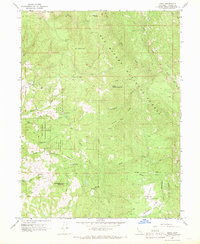
(16)- 1960 Map of Ukiah
 1960 Ukiah1960 Print · USGSNorthern California during the late fifties reveals a landscape of deep timber forests and valley agriculture before modern expansion. Trace the historic rail lines of the California Western RR and the Northwestern Pacific RR through settlements like Fort Bragg and Ukiah.2 unique versions available
 - 1963 Map of Weed
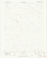
 1963 Weed1963 Print · USGSNorthern California during the early 1960s shows a landscape of steep mountain ranges and river-fed valleys at the height of the timber era. Researchers can trace the routes of the McCloud River RR, locate remote sites like the Holiday Mine, or find ancestral markers at the Scott Valley Cem.
 - 1966 Map of Leech Lake Mountain, 1969 Print
 1966 Leech Lake Mountain1969 Print · USGSThe high ridges of Mendocino County were defined by seasonal ranching and wilderness travel in the mid-1960s. Researchers can trace remote outposts like Osborn Station, Foster Ranch, and Travelers Home along a network of historic pack trails.3 unique versions available
 - 1967 Map of Schell Mtn, 1968 Print
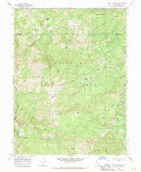
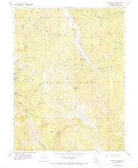
 1967 Schell Mtn1968 Print · USGSShasta and Trinity counties are shown here during the late 1960s, a period when reservoir recreation and high-country timber management defined the region. Researchers can trace the remnants of local industry and early ranching at the Lamoine Mill Site, Stoffard Shaft, and Norwegian Ranch.
 - 1967 Map of Long Ridge, 1969 Print
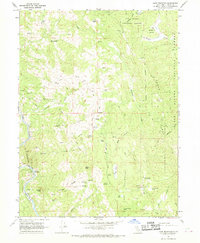
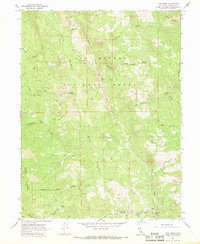 1967 Long Ridge1969 Print · USGSTrinity County ranching and forest life in the late sixties relied on a network of high ridges and canyon trails. Genealogists and historians can trace family sites like the Willie Hoaglin Place and Duncan Ranch near the Eel River.
 - 1967 Map of Mina, 1969 Print
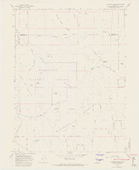
 1967 Mina1969 Print · USGSIn the late sixties, the remote borderlands of Mendocino and Trinity counties remained a landscape of isolated homesteads and high-country peaks. Researchers can locate the settlement of Mina, the Delmonico Place ranch, and geographic curiosities like Who Who Lake.2 unique versions available
 - 1967 Map of Updegraff Ridge, 1969 Print
 1967 Updegraff Ridge1969 Print · USGSThe Eel River canyon and the Trinity-Mendocino county line are captured here in the late 1960s. Genealogists and rail historians can trace the Northwestern Pacific Railroad through isolated stops at Bell Springs and Spyrock.3 unique versions available
 - 1967 Map of Shannon Butte, 1969 Print
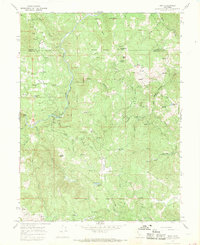
 1967 Shannon Butte1969 Print · USGSTrinity County ranching and remote forest life are detailed here during the late sixties. Genealogists and historians can trace family-named sites like Gilman Ranch, Shannon Place, and Crabtree Place along the Mad River.
 - 1967 Map of Buck Rock, 1969 Print
 1967 Buck Rock1969 Print · USGSMendocino and Trinity counties meet in this high wilderness during the late sixties, a landscape of remote ridges and deep forest glades. Trace the early routes of the Pacific Crest Road and find isolated backcountry sites like Beaver Glade Station and Hammerhorn Lake.2 unique versions available
 - 1967 Map of Bluenose Ridge, 1969 Print
 1967 Bluenose Ridge1969 Print · USGSMendocino and Trinity counties meet in this late 1960s look at a high-elevation backcountry frontier. Researchers can trace the Old Indian Treaty Boundary across Bluenose Ridge and find remote sites like Brown Ranch and Lightning Camp.4 unique versions available
 - 1967 Map of Lake Mountain, 1969 Print
 1967 Lake Mountain1969 Print · USGSTrinity County ranching and rail infrastructure are captured here in the late sixties. Researchers can trace the Northwestern Pacific Railroad through Island Mountain or locate family sites like Jamison Ranch and Hoaglin.2 unique versions available
 - 1967 Map of Zenia, 1969 Print
 1967 Zenia1969 Print · USGSTrinity County ranching and forestry communities are mapped here in the late sixties, showing the remote highlands between the forks of the Eel River. Researchers can locate the Hoaglin-Zenia Sch, the high Kettenpom Lookout Tower, and family sites like Shannon Ranch.2 unique versions available
 - 1969 Map of Bonanza King, 1971 Print
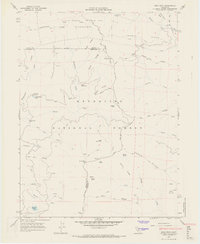
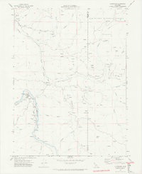
 1969 Bonanza King1971 Print · USGSThe Trinity Alps region at the end of the 1960s shows a landscape of historic mining claims and new recreation areas. Researchers can trace the heritage of the Bonanza King Mine or locate the site of Carrville near the shores of Clair Engle Lake.
 - 1969 Map of Jewett Rock, 1974 Print
 1969 Jewett Rock1974 Print · USGSThe Eel River canyon and surrounding ridgelines of Humboldt County are captured here just before the 1970s. Trace the remote rail operations of the Northwestern Pacific and find family landmarks like White Ranch, Schroeder Rock, and the Kekawaka Sta.2 unique versions available
 - 1969 Map of Bell Springs, 1974 Print
 1969 Bell Springs1974 Print · USGSMendocino County's high ridges and remote ranchlands are documented here in the late sixties, showing the isolated way of life along the mail route. Researchers can locate the mountain settlement at Bell Springs, the Linser Ranch, and high-country landmarks like Camel Rock.4 unique versions available
 - 1969 Map of Alderpoint, 1974 Print
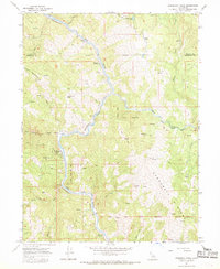
 1969 Alderpoint1974 Print · USGSThe Eel River canyon and surrounding ranches come into sharp focus in the late 1960s. Genealogists and local historians can trace the foundations of this community through family landmarks like Stockton Ranch, the Jewett Sch, and the Cain Rock Crossing.2 unique versions available
End of results
Showing maps 1-16 of 16
Top cities of Trinity County
- Weaverville historical maps
- Hayfork historical maps
- Lewiston historical maps
- Trinity Village historical maps
- Ruth historical maps
- Zenia historical maps
Frequently asked questions
- What are the different types of historical maps available for Trinity County?
- What is the oldest map of Trinity County?
- Where can I purchase historical maps of Trinity County for my home or office?
- Where can I download high-res historical maps of Trinity County?
- Are there historical topographic maps available for Trinity County?
- Is there historical aerial imagery available for Trinity County?
- Where are historical maps of Trinity County sourced from?