1950s Maps of Trinity County, California
Explore 35 historic maps of Trinity County from the 1950s. These maps offer a rare glimpse into what life looked like during the 1950s — showing old roads, neighborhoods, homes, and landmarks that have changed or disappeared over time.
Whether you're researching your family's past, planning a metal detecting trip, or studying how Trinity County's landscape evolved across the 1950s, these high-resolution maps are a powerful tool for exploring the history of this region.
- Focus on a specific era: All maps on this page are from the 1950s, giving you a focused view of this time period.
- See what’s changed: Compare century-old streets, trails, and buildings to today's modern landscape using overlays and satellite layers.
- Research with precision: Use these maps for genealogy, historical research, land use analysis, or educational projects.
- View, download, or print: Maps are fully viewable online in high resolution, and can be downloaded or printed for your own records.
Start exploring Trinity County's history through authentic maps from the 1950s. This is your window into the past.
Trinity County, CA maps
(35)- 1950 Map of Weed
 1950 Weed1950 Print · USGSSiskiyou County and the surrounding Klamath mountains appear in the mid-century before extensive modern development. Genealogists and local historians can locate remote outposts like the Lee Brown Ranch and the specialized settlement of Darlingtonia.
 - 1950 Map of Minersville, 1952 Print
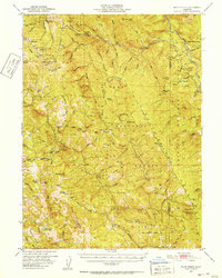
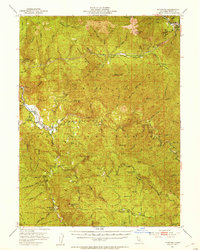
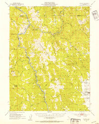
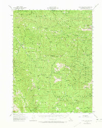
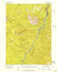
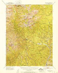 1950 Minersville1952 Print · USGSTrinity County's high country and early settlements are captured here in the early 1950s, just before the landscape was transformed by reservoir construction. Genealogists and historians can locate Old Minersville, Ridgeville (Site), and remote mountain locations like Bricks Ranch.4 unique versions available
 - 1950 Map of Schell Mtn, 1956 Print
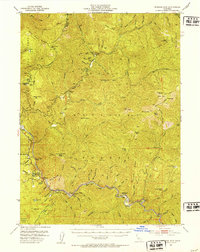
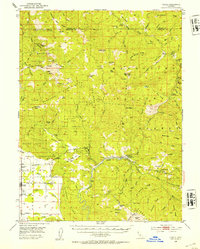
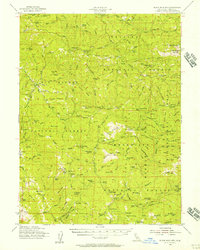
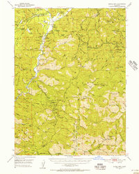 1950 Schell Mtn1956 Print · USGSThe Trinity River backcountry in the early 1950s reveals a landscape of isolated mountain ranches and active mining claims. Researchers can trace family-held lands like Norwegian Ranch and find old extraction sites such as Star Mine and Catherine Mine.2 unique versions available
 - 1950 Map of Weaverville, 1957 Print
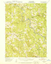
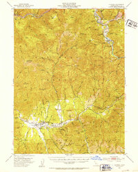
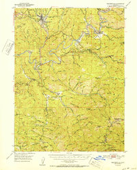
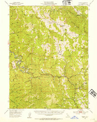
 1950 Weaverville1957 Print · USGSTrinity County's gold mining heritage remains prominent in the 1950s, centered on the historic town of Weaverville. Genealogists and historians can trace the cultural landscape through the Chinese Cem, La Grange Mine, and the remote Blanchard Flat School.2 unique versions available
 - 1951 Map of Alderpoint
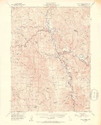
 1951 Alderpoint1951 Print · USGSSouthern Humboldt County is captured here at a time when the river-and-rail economy still shaped life along the Eel River. Researchers can trace old family holdings like Ware Ranch and Marr Ranch or locate the Harris PO and the Lumber Mill at Alderpoint.2 unique versions available
 - 1951 Map of Blocksburg
 1951 Blocksburg1951 Print · USGSHumboldt County ranching and timber country are captured here in the early fifties, spanning the divide between the Eel and Mad Rivers. Genealogists and historians can locate remote family holdings like Payton Ranch, the Buck Mtn School, and the Northwestern Pacific rail line at Eel Rock.2 unique versions available
 - 1951 Map of Pilot Creek, 1952 Print
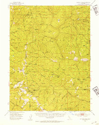
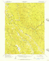
 1951 Pilot Creek1952 Print · USGSHumboldt and Trinity counties are shown during the early fifties, a time when remote cabins and mountain ranches still defined the high country. Genealogists and local historians can locate Ackley Ranch (Site of Fort Baker), Showers Pass, and the Cold Springs Lookout.5 unique versions available
 - 1951 Map of Hayfork, 1953 Print
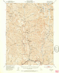
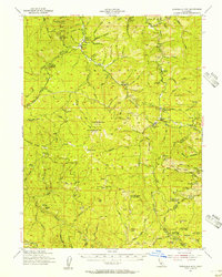
 1951 Hayfork1953 Print · USGSTrinity County in the early fifties remains a rugged territory of mountain ranches and deep-canyon mining claims. Researchers can trace the local economy through sites like the Trinity County Fairground in Hayfork and numerous mountain mines including the Kelly Mine and Kellogg Mine.6 unique versions available
 - 1951 Map of Helena, 1953 Print
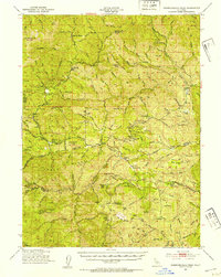
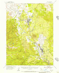
 1951 Helena1953 Print · USGSTrinity County’s rugged mining country is captured here in the early fifties, detailing the transition from active extraction to national forest management. Researchers can locate remote camps and historic gold operations like the Enterprise Mine, Dedrick, and Canyon City.5 unique versions available
 - 1951 Map of Chanchelulla Peak, 1953 Print
 1951 Chanchelulla Peak1953 Print · USGSNorthern California's interior mountains at the midpoint of the century reveal a landscape of isolated forest stations and family ranches. Researchers can locate the Midas Mine and trace early road networks connecting Platina with the Harrison Gulch Ranger Station and Deer Lick Springs.5 unique versions available
 - 1951 Map of Hyampom, 1953 Print
 1951 Hyampom1953 Print · USGSThe Trinity County mountains in the early fifties show a landscape of remote ranching and forest management. Researchers can locate family holdings like Grel Ranch, remote outposts at Camp Trinity, and the vital Landing Field at Hyampom.4 unique versions available
 - 1951 Map of Ironside Mountain, 1953 Print
 1951 Ironside Mountain1953 Print · USGSTrinity County's deep river canyons and forest ridges are captured here in the early fifties, showing a remote landscape defined by mining and mountain ranching. Researchers can locate family landmarks like Gray Ranch, old mining sites such as Index Mine, and riverside camps including Del Loma and Sandy Bar.4 unique versions available
 - 1952 Map of Schell Mtn.
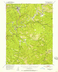
 1952 Schell Mtn.1952 Print · USGSThe high timber and river bars of the Trinity and Shasta county line are shown here in the early fifties. Genealogists and historians can trace old homesteads like Scott Ranch and remote sites such as the Lamoine Mill Site or Giddings Bar.2 unique versions available
 - 1952 Map of Weaverville
 1952 Weaverville1952 Print · USGSTrinity County in the early fifties remains a landscape defined by its mining roots and river-canyon settlements. Genealogists and historians can trace family locations from the Blanchard Flat School and Lowden Ranch to early industry at the La Grange Mine.2 unique versions available
 - 1952 Map of Willow Creek, 1954 Print
 1952 Willow Creek1954 Print · USGSThe Trinity River valley in the early fifties shows a mountain landscape of remote ranches and forest stations. Genealogists and historians can locate family landmarks like Russell Cabin, the Horse Mtn Mine, and the Cedar Grove Ranch.4 unique versions available
 - 1952 Map of Spyrock, 1954 Print
 1952 Spyrock1954 Print · USGSMendocino County ranching and rail life are documented here in the early fifties, centered on the Round Valley Indian Reservation. Trace the Northwestern Pacific line past Spyrock and Nashmead or locate the Lake Mtn Sch and the streets of Covelo.4 unique versions available
 - 1952 Map of Covelo, 1954 Print
 1952 Covelo1954 Print · USGSRound Valley in the early fifties remains a rugged hub of Mendocino ranching and indigenous life centered on the Covelo township. Genealogists and local historians can trace the foundations of the community at the Reservation School, Nomlackie Cem, and family landmarks like the Bauer Ranch.4 unique versions available
 - 1952 Map of Leggett, 1954 Print
 1952 Leggett1954 Print · USGSMendocino County’s mountain interior is mapped here in the early fifties, showing the logging and ranching country around the South Fork Eel River. Researchers can locate family landmarks like Drewry Ranch, the Linser Mine, and the historic Bell Springs Road.3 unique versions available
 - 1952 Map of Anthony Peak, 1954 Print
 1952 Anthony Peak1954 Print · USGSHigh mountain passes and forest service outposts define this corner of the California Coast Range during the early fifties. Local historians can locate specific mountain camps and former homesteads like Griffin Place, Howell Camp, and the Maxim Cabin (Site).4 unique versions available
 - 1953 Map of Blackrock Mtn, 1973 Print
 1953 Blackrock Mtn1973 Print · USGSTrinity County's high wilderness reaches are captured here in the mid-1950s, showing a landscape of steep river forks and high ridges. Genealogy researchers and hikers can trace the Humboldt Trail, locate the Travis Ranch, or find early outposts like Martin Cabin and Double Cabins.
 - 1954 Map of Pickett Peak, 1956 Print
 1954 Pickett Peak1956 Print · USGSTrinity County in the mid-fifties was a land of isolated ranches and timber works defined by the South Fork Trinity River. Genealogists and historians can locate family landmarks like Feldmiller Ranch, the Gilman Cem, and the Valley Hettenshaw School.3 unique versions available
 - 1954 Map of Dubakella Mtn, 1956 Print
 1954 Dubakella Mtn1956 Print · USGSMid-century Trinity County comes into focus in this survey of the mountainous terrain where Six Rivers National Forest meets the Shasta border. Researchers can trace old homesteads and mountain outposts like Peanut, Shiell Ranch, and the Old Bill Mine.3 unique versions available
 - 1954 Map of Weed, 1956 Print
 1954 Weed1956 Print · USGSMount Shasta and its surrounding timber towns come alive in this mid-century survey of Siskiyou County. Researchers can trace the path of the Southern Pacific through Weed and Edgewood, or locate specific landmarks like the Fish Hatchery and Mott.3 unique versions available
 - 1954 Map of Dunsmuir, 1957 Print
 1954 Dunsmuir1957 Print · USGSThe Sacramento River canyon in the 1950s was a critical transit corridor where the rail and road network shaped mountain life. Genealogists and historians can trace the canyon floor communities of Dunsmuir, Castella, and Shasta Retreat, or find remote landmarks like Whalan Station and Castle Rock Sch.4 unique versions available
 - 1954 Map of Blackrock Mtn, 1957 Print
 1954 Blackrock Mtn1957 Print · USGSThe Trinity and Mendocino highlands are mapped here in the mid-fifties, showing a landscape of remote mountain lookouts and forest camps. Genealogists and researchers can trace isolated homesteads and mining claims like Travis Ranch, Bonanza Mine, and the Indian Dick Guard Station.3 unique versions available
Showing maps 1-25 of 35
Top cities of Trinity County
- Weaverville historical maps
- Hayfork historical maps
- Lewiston historical maps
- Trinity Village historical maps
- Ruth historical maps
- Zenia historical maps
Frequently asked questions
- What are the different types of historical maps available for Trinity County?
- What is the oldest map of Trinity County?
- Where can I purchase historical maps of Trinity County for my home or office?
- Where can I download high-res historical maps of Trinity County?
- Are there historical topographic maps available for Trinity County?
- Is there historical aerial imagery available for Trinity County?
- Where are historical maps of Trinity County sourced from?