1940s Maps of Trinity County, California
Explore 5 historic maps of Trinity County from the 1940s. These maps offer a rare glimpse into what life looked like during the 1940s — showing old roads, neighborhoods, homes, and landmarks that have changed or disappeared over time.
Whether you're researching your family's past, planning a metal detecting trip, or studying how Trinity County's landscape evolved across the 1940s, these high-resolution maps are a powerful tool for exploring the history of this region.
- Focus on a specific era: All maps on this page are from the 1940s, giving you a focused view of this time period.
- See what’s changed: Compare century-old streets, trails, and buildings to today's modern landscape using overlays and satellite layers.
- Research with precision: Use these maps for genealogy, historical research, land use analysis, or educational projects.
- View, download, or print: Maps are fully viewable online in high resolution, and can be downloaded or printed for your own records.
Start exploring Trinity County's history through authentic maps from the 1940s. This is your window into the past.
Trinity County, CA maps
(5)- 1944 Map of French Gulch, 1957 Print
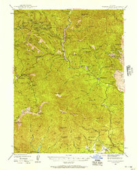 1944 French Gulch1957 Print · USGSThe mining districts of Shasta and Trinity counties are captured here in the mid-1940s, showcasing a landscape defined by gold extraction and rugged mountain summits. Researchers can trace historic claims and camps like French Gulch, the Brown Bear Mine, and the original site of Whiskeytown.2 unique versions available
 - 1948 Map of French Gulch
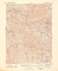 1948 French Gulch1948 Print · USGSShasta and Trinity counties are shown here in the late 1940s, capturing the region's deep mining heritage and rugged summit peaks. Genealogists and historians can locate vanished mining camps and landmarks like Deadwood, the Niagara Mine, and Whiskeytown.2 unique versions available
 - 1948 Map of Weed, 1950 Print
 1948 Weed1950 Print · USGSNorthern California and Southern Oregon are captured here during the post-war era, documenting the mountain-and-valley economies of the Klamath and Cascade ranges. Trace the legacy of local mining and timber at the King Solomon Mine, find old schools like Siskiyou County School, and follow the historic Southern Pacific RR route.2 unique versions available
 - 1949 Map of Blocksburg, 1955 Print
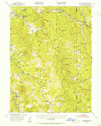 1949 Blocksburg1955 Print · USGSHumboldt County ranching and timberlands are captured here in the late 1940s, showing the remote canyon country before modern development. Genealogists and local historians can locate early family holdings like Cobb Ranch and the vanished Buck Mtn School.2 unique versions available
 - 1949 Map of Alderpoint, 1955 Print
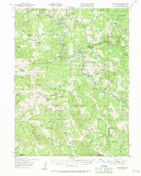 1949 Alderpoint1955 Print · USGSHumboldt County ranching and timber life are captured here in the late 1940s as the railroad follows the winding Eel River. Researchers can trace old family holdings like Ware Ranch and Marr Ranch or locate the site of the Harris PO and Fort Seward.3 unique versions available
End of results
Showing maps 1-5 of 5
Top cities of Trinity County
- Weaverville historical maps
- Hayfork historical maps
- Lewiston historical maps
- Trinity Village historical maps
- Ruth historical maps
- Zenia historical maps
Frequently asked questions
- What are the different types of historical maps available for Trinity County?
- What is the oldest map of Trinity County?
- Where can I purchase historical maps of Trinity County for my home or office?
- Where can I download high-res historical maps of Trinity County?
- Are there historical topographic maps available for Trinity County?
- Is there historical aerial imagery available for Trinity County?
- Where are historical maps of Trinity County sourced from?