1940s Maps of Franklin County, Florida
Explore 35 historic maps of Franklin County from the 1940s. These maps offer a rare glimpse into what life looked like during the 1940s — showing old roads, neighborhoods, homes, and landmarks that have changed or disappeared over time.
Whether you're researching your family's past, planning a metal detecting trip, or studying how Franklin County's landscape evolved across the 1940s, these high-resolution maps are a powerful tool for exploring the history of this region.
- Focus on a specific era: All maps on this page are from the 1940s, giving you a focused view of this time period.
- See what’s changed: Compare century-old streets, trails, and buildings to today's modern landscape using overlays and satellite layers.
- Research with precision: Use these maps for genealogy, historical research, land use analysis, or educational projects.
- View, download, or print: Maps are fully viewable online in high resolution, and can be downloaded or printed for your own records.
Start exploring Franklin County's history through authentic maps from the 1940s. This is your window into the past.
Franklin County, FL maps
(35)- 1940 Map of Arran, 1966 Print
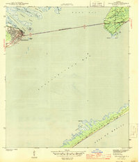
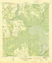
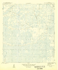
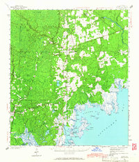 1940 Arran1966 Print · USGSWakulla County's coastal forests and rail-linked settlements are captured here in the era just before the Second World War. Researchers can locate family landmarks like Roddenberry Cem, the historic Wakulla Springs, and rural hubs such as Sopchoppy and Panacea.
 - 1943 Map of Arran
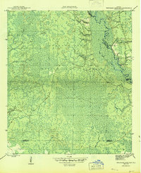
 1943 Arran1943 Print · USGSWakulla County's coastal lowlands and timber forests are captured here just before the mid-century, centered on CRAWFORDVILLE and the Seaboard Air Line. Genealogists can trace family footprints at Roddenberry Cem, Pilgrims Rest Ch, and the rural Mt Pleasant Sch.2 unique versions available
 - 1943 Map of Dog Island
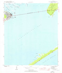
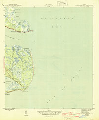
 1943 Dog Island1943 Print · USGSThe Florida coast at the height of World War II reveals a landscape of military readiness and wild barrier islands. Researchers can trace the footprint of Camp Gordon Johnson and its rail connection to the Seaboard line, or explore the unpopulated reaches of Dog Island.4 unique versions available
 - 1943 Map of West Pass
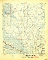
 1943 West Pass1943 Print · USGSThe Franklin County coastline comes alive in this wartime survey of the marshes and barrier islands surrounding Apalachicola. Researchers can trace the early layout of Nine Mile, the P and R Ranch, and the Apalachicola Northern railroad line.5 unique versions available
 - 1943 Map of Apalachicola
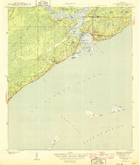
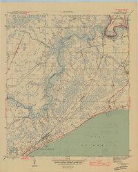
 1943 Apalachicola1943 Print · USGSCoastal Franklin County at the height of the war years reveals a landscape defined by its river-and-rail economy. Genealogists and historians can trace the streets of Apalachicola, the crossing to Eastpoint, and landmarks like Godleys Bluff and the Apalachicola Northern rail line.4 unique versions available
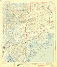
 - 1943 Map of Carrabelle, 1968 Print
 1943 Carrabelle1968 Print · USGSCoastal Franklin County comes to life in the 1940s, showing the intersection of the maritime economy and the dense Florida wetlands. Researchers can trace the Seaboard rail line into Carrabelle or locate landmarks like the Carrabelle Lighthouse and Yent Place.
 - 1943 Map of St. Teresa Beach, 1969 Print
 1943 St. Teresa Beach1969 Print · USGSThe Florida Panhandle coastline during the early 1940s shows a landscape of tidal rivers and quiet shorelines before modern expansion. Genealogists and historians can trace the early layout of St Teresa Beach and the wilderness boundaries of the St Marks National Wildlife Refuge.
 - 1943 Map of Indian Pass, 1973 Print
 1943 Indian Pass1973 Print · USGSThe Franklin County coastline was a rugged maritime landscape during the 1940s, marked by small shoreline settlements and military outposts. Researchers can trace the Apalachicola Northern rail line or locate coastal features like Indian Pass, Odena, and Coast Guard Sta No 105.
 - 1943 Map of Jackson River, 1975 Print
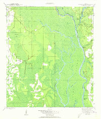
 1943 Jackson River1975 Print · USGSThe Florida panhandle river deltas remained largely wild and water-bound in the early 1940s. Genealogists and local historians can trace family land ties near Box R Ranch or navigate the intricate sloughs around St Marks Island and Lake Wimico.
 - 1943 Map of Lighthouse Point, 1976 Print
 1943 Lighthouse Point1976 Print · USGSCoastal Franklin County in the early 1940s was a landscape defined by tidal marshes and isolated fishing outposts. Genealogists and historians can trace early commercial sites like Ochlockonee Fishery and Sunday Reel Fishery or explore the unbridged reaches of St James Island.
 - 1944 Map of Pickett Bay
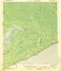
 1944 Pickett Bay1944 Print · USGSCoastal Franklin County was a vital military landscape during the 1940s, characterized by the vast wetlands of the Panhandle. Researchers can trace the footprint of Tates Hell Swamp Military Reservation and locate the former site of Harbeson City (abandoned) along the Crooked River.
 - 1944 Map of Carrabelle
 1944 Carrabelle1944 Print · USGSCoastal Florida comes to life in the mid-1940s, showcasing the intersection of the Seaboard Railway and the Gulf waters. Genealogists and historians can trace families at Yent Place, locate the Carrabelle Lighthouse, and explore the reach of Tates Hell Swamp.4 unique versions available
 - 1944 Map of Green Point
 1944 Green Point1944 Print · USGSThe Florida Panhandle coast near Franklin is captured in the mid-1940s, showing a wild landscape of coastal bayous and deep swamps. Trace early infrastructure like the Abandoned RR Grade or locate the Porters Bar Cem and Royal Bluff along the sound.4 unique versions available
 - 1944 Map of Sugar Hill, 1945 Print
 1944 Sugar Hill1945 Print · USGSSt George Island remains largely a natural wilderness of sand and surf during the mid-1940s. Researchers can trace the coastal topography of St George Sound and locate landmarks like the original Sugar Hill and its surrounding Dunes.
 - 1944 Map of Apalachicola, 1960 Print
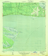
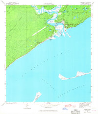
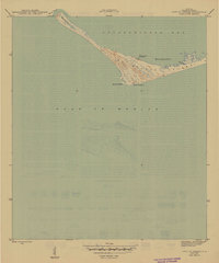
 1944 Apalachicola1960 Print · USGSFlorida's Forgotten Coast comes to life in the mid-1940s as the riverfront town of Apalachicola connects to the mainland. Trace the early layout of Eastpoint and explore the natural shoreline from Godleys Bluff to the dunes of St George Island.
 - 1944 Map of Forbes Island, 1960 Print
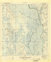
 1944 Forbes Island1960 Print · USGSThe Florida Panhandle river system is frozen in time during the mid-1940s, highlighting the industrial timber operations of the Gulf and Liberty county borders. Researchers can trace the path of the Logging RR to remote sites like Lister Camp or locate riverfront hubs such as Brickyard Landing.2 unique versions available
 - 1945 Map of Cape St. George
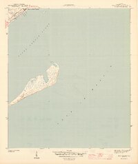
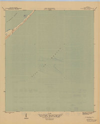
 1945 Cape St. George1945 Print · USGSThe Florida Panhandle's barrier islands appear here during the mid-1940s, highlighting the strategic maritime geography of Franklin County. Researchers can locate the Cape St George L H and the Coast Guard Landing near the waters of West Pass.3 unique versions available
 - 1945 Map of Forbes Island
 1945 Forbes Island1945 Print · USGSThe river-driven economy of Gulf County is captured here in the mid-1940s, highlighting a landscape of wetlands and timber camps. Genealogists and researchers can trace local landings like Smith Creek Landing and isolated outposts such as Lister Camp or Glenn Hammock.3 unique versions available
 - 1945 Map of Lake Wimico
 1945 Lake Wimico1945 Print · USGSThe Florida panhandle wetlands are captured here at the end of the war, revealing a landscape of timber and transit. Researchers can trace the path of the Old Logging RR or follow the Intracoastal Waterway past Clay Cut.5 unique versions available
 - 1945 Map of Thousand Yard Bay
 1945 Thousand Yard Bay1945 Print · USGSLiberty County during the mid-1940s reveals a landscape defined by the winding Ochlockonee River and the depths of the Apalachicola National Forest. Trace local history at Roberts Landing and explore the distinct topography of Thousand Yard Bay.3 unique versions available
 - 1945 Map of Kennedy Creek
 1945 Kennedy Creek1945 Print · USGSThe Florida Panhandle at the close of the war shows a river-dependent landscape where Liberty and Gulf counties meet. Local historians can trace old river outposts like White Oak Landing and Owl Landing, or locate the Graveyard Pole Lookout deep in the swampy interior.4 unique versions available
 - 1945 Map of Lighthouse Point
 1945 Lighthouse Point1945 Print · USGSCoastal Franklin County comes alive in the mid-1940s, showing a landscape defined by seasonal industry and tidal reaches. Genealogists and historians can locate specific working waterfronts like the Ochlockonee Fishery, Mud Cove Fishery, and Sunday Reel Fishery.3 unique versions available
 - 1945 Map of Tates Hell Swamp
 1945 Tates Hell Swamp1945 Print · USGSFlorida's Panhandle was a center of timber production in the 1940s, as shown by the dense network of rail lines throughout Tates Hell Swamp. Trace the paths of the Old Logging RR and follow waterways like Whisky George Creek.4 unique versions available
 - 1945 Map of Mc Intyre
 1945 Mc Intyre1945 Print · USGSThe Florida Panhandle coastline and inland forests appear here during the height of the Second World War. Researchers can trace the massive Camp Gordon Johnson complex near Lanark or locate the historic Pinelog Ferry crossing on the Crooked River.6 unique versions available
 - 1945 Map of Sugar Hill
 1945 Sugar Hill1945 Print · USGSSt George Island remains a wild barrier landscape during the mid-1940s, separating the sound from the open gulf. Researchers can trace the original topography of the island's narrowest points, identifying natural landmarks like Sugar Hill and the shifting Dunes.2 unique versions available
Showing maps 1-25 of 35
Top cities of Franklin County
Frequently asked questions
- What are the different types of historical maps available for Franklin County?
- What is the oldest map of Franklin County?
- Where can I purchase historical maps of Franklin County for my home or office?
- Where can I download high-res historical maps of Franklin County?
- Are there historical topographic maps available for Franklin County?
- Is there historical aerial imagery available for Franklin County?
- Where are historical maps of Franklin County sourced from?