1940s Maps of Elmore County, Idaho
Explore 35 historic maps of Elmore County from the 1940s. These maps offer a rare glimpse into what life looked like during the 1940s — showing old roads, neighborhoods, homes, and landmarks that have changed or disappeared over time.
Whether you're researching your family's past, planning a metal detecting trip, or studying how Elmore County's landscape evolved across the 1940s, these high-resolution maps are a powerful tool for exploring the history of this region.
- Focus on a specific era: All maps on this page are from the 1940s, giving you a focused view of this time period.
- See what’s changed: Compare century-old streets, trails, and buildings to today's modern landscape using overlays and satellite layers.
- Research with precision: Use these maps for genealogy, historical research, land use analysis, or educational projects.
- View, download, or print: Maps are fully viewable online in high resolution, and can be downloaded or printed for your own records.
Start exploring Elmore County's history through authentic maps from the 1940s. This is your window into the past.
Elmore County, ID maps
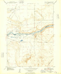
(35)- 1946 Map of Mouth of Bruneau, 1967 Print
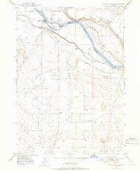
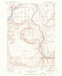
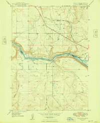
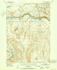
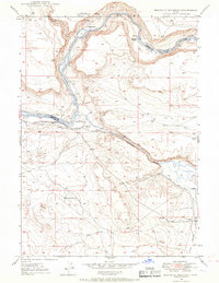 1946 Mouth of Bruneau1967 Print · USGSThe confluence of the Snake and Bruneau rivers in the late 1940s reveals a landscape shaped by overland migration and canyon ranching. Genealogists and historians can trace the Emigrant Trail and locate family landmarks like the Roy Johnson Ranch or Halls Ferry.3 unique versions available
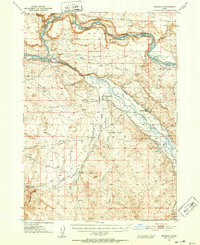
 - 1947 Map of Grand View, 1952 Print
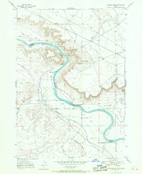
 1947 Grand View1952 Print · USGSOwyhee County ranching and irrigation are captured here at the end of the 1940s, centered on the riverfront settlement of Grand View. Researchers can trace early family holdings like Whitson Ranch or find the Cem and Landing Strip near the banks of the Snake River.2 unique versions available
 - 1947 Map of Bruneau, 1952 Print
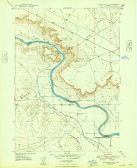
 1947 Bruneau1952 Print · USGSThe confluence of the Snake and Bruneau Rivers in the late 1940s reveals a rugged landscape defined by pioneer history and modern irrigation. Researchers can trace the Emigrant Trail to the Halls Ferry (Site) and locate landmarks like the Little Valley Sch (Aban'd) and ancient Petroglyphs.2 unique versions available
 - 1947 Map of Indian Cove, 1963 Print
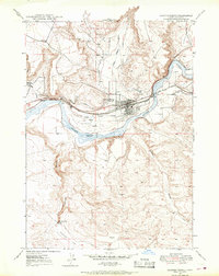
 1947 Indian Cove1963 Print · USGSSouthern Idaho's high desert reveals its transit history in the 1940s as the Old Oregon Trail and Union Pacific traverse the Snake River canyon. Trace the development of the region through landmarks like Chalk Spur, the Indian Cove Bridge, and Sparlin Island.4 unique versions available
 - 1947 Map of Grand View, 1966 Print
 1947 Grand View1966 Print · USGSOwyhee County's high desert meets the river's edge in the late 1940s, revealing an era of expanding irrigation and ranching. Genealogists and historians can trace family land at Whitson Ranch, locate the Cem, or study the early engineering of the Low Line Canal.3 unique versions available
 - 1947 Map of Hammett, 1966 Print
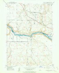
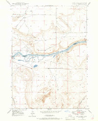
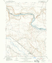
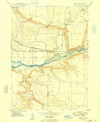
 1947 Hammett1966 Print · USGSThe Snake River corridor in Idaho comes alive in the late 1940s, showing the intersection of pioneer paths and modern irrigation. Trace the Old Oregon Trail as it passes through Hammett, and locate the Medbury Ferry and McGinness Ranch along the river.2 unique versions available
 - 1947 Map of Sand Dunes, 1966 Print
 1947 Sand Dunes1966 Print · USGSOwyhee County's high desert meets the river in the late 1940s, a landscape defined by the migrating Sand Dunes and the powerful Snake River. Genealogists and historians can trace the routes of the Emigrant Trail and the Old Mountain Home Trail past landmarks like Barber Cabin.4 unique versions available
 - 1947 Map of Glenns Ferry, 1968 Print
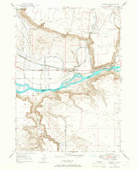
 1947 Glenns Ferry1968 Print · USGSGlenns Ferry and the Snake River valley are captured in the late 1940s, highlighting a landscape defined by historic emigrant paths and rail infrastructure. You can trace the route of the Oregon Trail as it meets the Snake River at Three Island Crossing.2 unique versions available
 - 1947 Map of Pasadena Valley, 1968 Print
 1947 Pasadena Valley1968 Print · USGSElmore County's river-driven landscape is captured here in the late 1940s as irrigation and historical trails converge along the Snake River. Researchers can trace the Old Oregon Trail past the Pilgrim Stage Sta Historic Site and the Pasadena Valley Sch.2 unique versions available
 - 1947 Map of Bruneau, 1968 Print
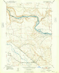
 1947 Bruneau1968 Print · USGSThe Owyhee County desert meets the river canyons in the late 1940s, where pioneer history and irrigation agriculture overlap. Trace the historic Emigrant Trail down to the Emigrant Crossing and find the location of the Little Valley Sch (Aban'd).3 unique versions available
 - 1947 Map of Jackass Butte, 1971 Print
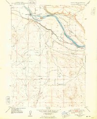
 1947 Jackass Butte1971 Print · USGSThe Snake River canyon and the high desert bluffs of Owyhee County come alive in this late 1940s survey. Researchers can trace the path of the historic Emigrant Trail and locate local landmarks like Brooks Ranch, Birch Creek Sch, and Rabbit Springs.2 unique versions available
 - 1947 Map of Dorsey Butte, 1979 Print
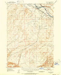
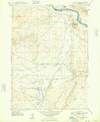
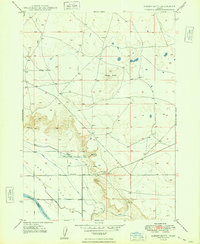
 1947 Dorsey Butte1979 Print · USGSElmore County's high desert landscape is captured here in the late 1940s as irrigation projects transformed the arid basin. Researchers can trace the local water economy through the High Line Canal and locate the historic Hayland Sch near Chattin Hill.
 - 1948 Map of Castle Butte
 1948 Castle Butte1948 Print · USGSOwyhee County ranching and transit corridors are captured here in the late 1940s as the high plateau supported isolated homesteads and water projects. Researchers can trace the historic Emigrant Trail and locate local landmarks such as the Castle Creek Sch, Morgan Place, and the site of Clarks Ferry.2 unique versions available
 - 1948 Map of Pasadena Valley
 1948 Pasadena Valley1948 Print · USGSThe Snake River canyon in the late 1940s reveals a landscape defined by vital irrigation works and transcontinental rail. Trace the historic Pilgrim Stage Sta Historic Site and follow the intricate King Hill Main Canal as it waters Pasadena Valley.
 - 1948 Map of Sand Dunes
 1948 Sand Dunes1948 Print · USGSThe Snake River canyon serves as a crossroads for historical travel in the late 1940s, where desert plateaus meet the water's edge. Researchers can trace the path of the Emigrant Trail and the Old Freight Trail near landmarks like Loveridge Bridge.
 - 1948 Map of Hammett
 1948 Hammett1948 Print · USGSElmore County during the late 1940s reveals a landscape defined by the intersection of the historic Old Oregon Trail and the vital Union Pacific railroad. Genealogists and historians can locate the Medbury Ferry, McGuinness Ranch, and island settlements along the Snake River.
 - 1948 Map of Grand View
 1948 Grand View1948 Print · USGSThe high desert of Owyhee County was a land of ranching and irrigation in the late 1940s. Genealogists and researchers can trace family-named homesteads such as Dixie Ranch and Whitson Ranch, alongside vital water sources like Artesian Wells and Hinton Res.
 - 1948 Map of Glenns Ferry
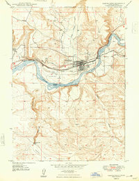 1948 Glenns Ferry1948 Print · USGSGlenns Ferry is captured here in the late 1940s as a critical river crossing where the railroad meets pioneering history. Trace the path of the Old Oregon Trail and locate local landmarks like Slick Bridge, Three Island Crossing, and the Landing Field.
 - 1948 Map of Indian Cove
 1948 Indian Cove1948 Print · USGSThe high desert breaks into the Snake River canyon in this postwar Idaho survey, where the Old Oregon Trail still marks the plateau. Researchers can trace the Union Pacific railroad through Chalk Cut or locate historical river infrastructure like the Indian Cove Bridge.
 - 1948 Map of Jackass Butte
 1948 Jackass Butte1948 Print · USGSThe Snake River canyon in Owyhee County was a critical corridor for both pioneers and post-war irrigators during the late 1940s. Researchers can trace the path of the Emigrant Trail or locate local landmarks like Brooks Ranch and Birch Creek Sch.
 - 1948 Map of Bruneau
 1948 Bruneau1948 Print · USGSOwyhee County's high-desert ranching and river landscape is captured here in the years following World War II. Researchers can trace the historic Emigrant Trail and locate local landmarks like the Little Valley Sch (Aban'd) and Crane Falls.
 - 1948 Map of Dorsey Butte
 1948 Dorsey Butte1948 Print · USGSElmore County during the late 1940s reveals a quiet landscape of high desert flats and river borders just as postwar ranching was modernizing. Researchers can locate the Hayland Sch, a private Landing Strip, and the rugged landmarks of Dorsey Butte and Chattin Hill.
 - 1948 Map of Indian Cove, 1952 Print
 1948 Indian Cove1952 Print · USGSOwyhee County and the Snake River are captured here in the late 1940s, showing a rugged landscape of rail spurs and geothermal springs. Researchers can trace the Oregon Short Line near Medbury Hill or locate the Bruneau Cem and Indian Bathtub.2 unique versions available
 - 1948 Map of Big Foot Butte, 1952 Print
 1948 Big Foot Butte1952 Print · USGSIn the late 1940s, the Snake River canyon served as the heart of a transforming Idaho ranching and irrigation landscape. Researchers can trace the path of the Emigrant Trail or locate vanished landmarks like Birch Creek School and the Brooks Ranch.
 - 1948 Map of Twentymile Butte, 1964 Print
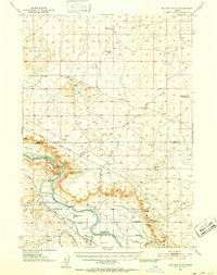
 1948 Twentymile Butte1964 Print · USGSThe high plateau country of Elmore and Owyhee Counties is captured here in the late 1940s, showing a landscape shaped by water and elevation. Trace the old route of the Glenns Ferry Castleford Road as it passes landmarks like Twentymile Butte and Deadman Flat.
Showing maps 1-25 of 35
Top cities of Elmore County
Frequently asked questions
- What are the different types of historical maps available for Elmore County?
- What is the oldest map of Elmore County?
- Where can I purchase historical maps of Elmore County for my home or office?
- Where can I download high-res historical maps of Elmore County?
- Are there historical topographic maps available for Elmore County?
- Is there historical aerial imagery available for Elmore County?
- Where are historical maps of Elmore County sourced from?