1940s Maps of Fremont County, Idaho
Explore 2 historic maps of Fremont County from the 1940s. These maps offer a rare glimpse into what life looked like during the 1940s — showing old roads, neighborhoods, homes, and landmarks that have changed or disappeared over time.
Whether you're researching your family's past, planning a metal detecting trip, or studying how Fremont County's landscape evolved across the 1940s, these high-resolution maps are a powerful tool for exploring the history of this region.
- Focus on a specific era: All maps on this page are from the 1940s, giving you a focused view of this time period.
- See what’s changed: Compare century-old streets, trails, and buildings to today's modern landscape using overlays and satellite layers.
- Research with precision: Use these maps for genealogy, historical research, land use analysis, or educational projects.
- View, download, or print: Maps are fully viewable online in high resolution, and can be downloaded or printed for your own records.
Start exploring Fremont County's history through authentic maps from the 1940s. This is your window into the past.
Fremont County, ID maps
(2)- 1948 Map of Parker, 1973 Print
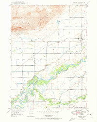 1948 Parker1973 Print · USGSFremont and Madison counties are captured here just after the war, showing the intensive irrigation and rail network of the upper Snake River Valley. Trace family roots and land use near Parker, Salem, and the Fort Henry Historic Monument.2 unique versions available
 - 1949 Map of Newdale, 1966 Print
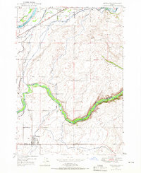 1949 Newdale1966 Print · USGSSoutheast Idaho at the end of the 1940s is defined by a intricate network of irrigation and rail. Researchers can trace the agricultural development around Chester and Newdale, following features like the Chester Cem, the Union Pacific line, and the deep winding gorge of the Teton River.2 unique versions available
End of results
Showing maps 1-2 of 2
Top cities of Fremont County
- St. Anthony historical maps
- Ashton historical maps
- Teton historical maps
- Parker historical maps
- Island Park historical maps
- Warm River historical maps
Frequently asked questions
- What are the different types of historical maps available for Fremont County?
- What is the oldest map of Fremont County?
- Where can I purchase historical maps of Fremont County for my home or office?
- Where can I download high-res historical maps of Fremont County?
- Are there historical topographic maps available for Fremont County?
- Is there historical aerial imagery available for Fremont County?
- Where are historical maps of Fremont County sourced from?