Old Maps of Fremont County, Idaho for Genealogy
Trace your family roots with 349 historic maps of Fremont County. These high-res maps reveal old neighborhoods, homesites, landmarks, and streets — helping you uncover where your ancestors lived and how the area evolved over time.
- Explore historic neighborhoods: Identify where your relatives may have lived in the 1800s or 1900s.
- Compare maps over time: Trace the changes in streets, buildings, and landmarks for multi-generational research.
- Perfect for genealogy & ancestry research: Used by family historians and researchers to map out lineage and migration.
These maps are an incredible resource for exploring your personal connection to Fremont County's past.
Fremont County, ID maps
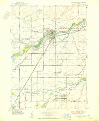
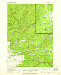
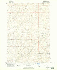
(349)- 1948 Map of Parker, 1973 Print
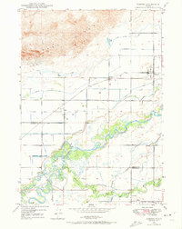 1948 Parker1973 Print · USGSFremont and Madison counties are captured here just after the war, showing the intensive irrigation and rail network of the upper Snake River Valley. Trace family roots and land use near Parker, Salem, and the Fort Henry Historic Monument.2 unique versions available
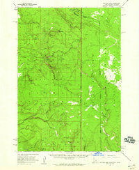
 - 1949 Map of Newdale, 1966 Print
 1949 Newdale1966 Print · USGSSoutheast Idaho at the end of the 1940s is defined by a intricate network of irrigation and rail. Researchers can trace the agricultural development around Chester and Newdale, following features like the Chester Cem, the Union Pacific line, and the deep winding gorge of the Teton River.2 unique versions available
 - 1950 Map of Parker
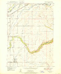
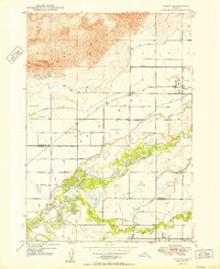 1950 Parker1950 Print · USGSThe northern Snake River Plain comes into focus in this midcentury survey as agricultural irrigation meets the shifting Sand Dunes. Genealogists and historians can trace the irrigation networks of the St Anthony Canal, settlements like Parker, and the Fort Henry Historic Monument.
 - 1950 Map of Newdale
 1950 Newdale1950 Print · USGSEastern Idaho’s agricultural heartland is captured here in the 1950s, showing the complex irrigation network between the Teton River and Fall River. Researchers can trace the Union Pacific rail lines and early road systems connecting Newdale and Chester.
 - 1950 Map of St Anthony
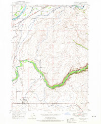
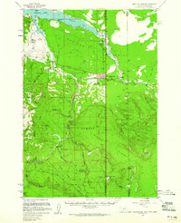
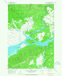
 1950 St Anthony1950 Print · USGSMid-century Fremont County is defined here by the meeting of the Henrys Fork and the Teton River amidst a massive irrigation network. Researchers can trace the Union Pacific rail line through St. Anthony and locate the Idaho Industrial Training School or Riverview Cemetery.3 unique versions available
 - 1950 Map of Hebgen Dam, 1954 Print
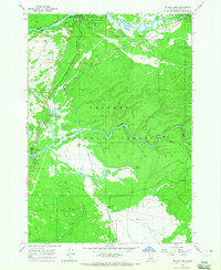
 1950 Hebgen Dam1954 Print · USGSThe Madison Range and the high country of the Montana-Idaho border come alive in this mid-century survey. You can trace the ranching and early tourism of the era through sites like Olifee Ranch, Campfire Lodge, and the remote Watkins Creek Ranch airstrip.7 unique versions available
 - 1950 Map of Upper Red Rock Lake, 1954 Print
 1950 Upper Red Rock Lake1954 Print · USGSThe Centennial Valley and the Continental Divide are documented here in the early fifties, featuring the expansive Upper Red Rock Lake. Researchers can trace old family holdings like the Hanson Ranch and Cook Sheep Ranch or locate the Selby Resort and early forest campgrounds.3 unique versions available
 - 1951 Map of Plano, 1953 Print
 1951 Plano1953 Print · USGSFremont and Madison counties are captured here in the early 1950s as irrigation canals transformed the desert into farmland. Genealogists can locate family names and burial sites at the Plano Cem near Plano and trace the path of the Independent Canal.2 unique versions available
 - 1955 Map of Dubois
 1955 Dubois1955 Print · USGSThe high desert and mountain passes of eastern Idaho and western Montana are captured here during the mid-fifties. Researchers can trace the Union Pacific rail line through Dubois or locate the National Reactor Testing Station.4 unique versions available
 - 1955 Map of Idaho Falls, 1963 Print
 1955 Idaho Falls1963 Print · USGSThe Snake River Plain and its surrounding volcanic peaks are captured in the late fifties, showing the region's unique mix of nuclear research and high-desert ranching. Trace the industrial footprint of the National Reactor Testing Station or find old mining sites like Empire Mine.5 unique versions available
 - 1955 Map of Ashton, 1967 Print
 1955 Ashton1967 Print · USGSThe Greater Yellowstone ecosystem is captured here during the mid-1950s, showing the high plateaus and remote gateway towns of Idaho and Montana. Researchers can trace the Union Pacific line to Ashton or locate small settlements like Squirrel and Grainville.4 unique versions available
 - 1955 Map of Driggs, 1967 Print
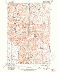
 1955 Driggs1967 Print · USGSEastern Idaho and Western Wyoming appear at a mid-century crossroads as the river valleys were fully settled and the high peaks protected. Genealogists and researchers can trace the rail towns of Rexburg and Driggs or follow the Snake River from Irwin to the Palisades Reservoir.3 unique versions available
 - 1957 Map of Warm River Butte, 1958 Print
 1957 Warm River Butte1958 Print · USGSEastern Idaho and the edge of Yellowstone are mapped here in the late fifties, showing a remote landscape of high-country ranches and federal forest outposts. Genealogists and historians can trace the locations of the Kelly School, Howell Ranch, and the Old Marysville Road.3 unique versions available
 - 1957 Map of Buffalo Lake, 1959 Print
 1957 Buffalo Lake1959 Print · USGSHigh in the northern Rockies during the late fifties, the borders of Idaho, Montana, and Wyoming meet along the high spine of the Continental Divide. Trace the remote wilderness of the Madison Plateau and locate isolated landmarks like the Patrol Cabin or Latham Spring.2 unique versions available
 - 1958 Map of Driggs
 1958 Driggs1958 Print · USGSThe high Teton peaks and Snake River valleys are captured here in the mid-fifties, showing the region's agricultural and wilderness boundaries. Researchers can trace the Union Pacific rail corridor through Rexburg or locate early settlements like Clementsville and Tetonia.2 unique versions available
 - 1958 Map of Dubois
 1958 Dubois1958 Print · USGSThe high divide between Idaho and Montana comes alive in this mid-century survey, from the mining camps of the Lemhi Range to the ranchlands of Centennial Valley. Trace historic operations at the Copper Queen Mine, the route of the Union Pacific RR, and the scientific work at the Sheep experimental station.2 unique versions available
 - 1958 Map of Idaho Falls
 1958 Idaho Falls1958 Print · USGSEastern Idaho in the late fifties showcases the rapid expansion of agricultural and scientific outposts across its volcanic plains. Researchers can locate remote sites like Atomic City, mineral interests at White Knob Mine, and the cultural grounds of St Marys Mission.2 unique versions available
 - 1958 Map of Ashton
 1958 Ashton1958 Print · USGSGreater Yellowstone and the eastern Idaho borderlands appear here in the mid-1950s as rail and road networks connected remote mountain basins. Trace the Union Pacific route through Ashton or locate early outposts like Last Chance, Squirrel, and West Yellowstone.
 - 1958 Map of West Yellowstone, 1960 Print
 1958 West Yellowstone1960 Print · USGSWest Yellowstone and the surrounding national forests are captured here in the late fifties, just before a major earthquake altered the region. Researchers can trace early park access via the Union Pacific and locate remote outposts like Whitmans Cabin and the Basin Ranger Sta.3 unique versions available
 - 1960 Map of Ashton
 1960 Ashton1960 Print · USGSThe Idaho-Montana-Wyoming borderlands at the dawn of the sixties show a landscape defined by the Continental Divide and early wilderness tourism. Genealogists and historians can trace rail-stop settlements like Trude Siding, old outposts like Warm River, and early lodging at Snowball Inn.
 - 1962 Map of Driggs
 1962 Driggs1962 Print · USGSThe Idaho-Wyoming borderlands are captured here in the early sixties, showing the peaks and valleys of the northern Rockies. Genealogists and historians can trace rail lines like the Union Pacific RR and isolated outposts like the National Elk Refuge or the Fort Hall Indian Reservation.
 - 1964 Map of Hatchery Butte, 1965 Print
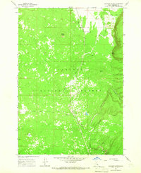 1964 Hatchery Butte1965 Print · USGSFremont County's timbered uplands are captured here in the mid-1960s, showing the intersection of the Union Pacific railroad and the Targhee National Forest. Researchers can trace the rail line through Eccles or locate recreation sites like Pineview Campground and Lily Pond.2 unique versions available
 - 1964 Map of Dubois NE, 1965 Print
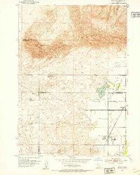
 1964 Dubois NE1965 Print · USGSSoutheastern Clark County remains a high-desert expanse of ranching and creek drainages during the mid-1960s. Genealogists and local historians can locate the Jacoby Ranch and trace the winding course of Camas Creek near the county line.
 - 1964 Map of Island Park, 1965 Print
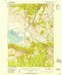
 1964 Island Park1965 Print · USGSEastern Idaho was a landscape of federal forestry and growing tourism in the 1960s. Genealogists and historians can trace the foundations of local recreation at the Island Park Reservoir, Macks Inn PO, and the Union Pacific rail corridor.3 unique versions available
 - 1964 Map of Island Park Dam, 1966 Print
 1964 Island Park Dam1966 Print · USGSFremont County, Idaho, is shown in the mid-1960s during a period of burgeoning outdoor recreation and water management. Researchers can trace ranching and reservoir life through features like McCrea Ranch, the Island Park Dam, and I P Bills Island.3 unique versions available
Showing maps 1-25 of 349
Top cities of Fremont County
- St. Anthony historical maps
- Ashton historical maps
- Teton historical maps
- Parker historical maps
- Island Park historical maps
- Warm River historical maps
Frequently asked questions
- What are the different types of historical maps available for Fremont County?
- What is the oldest map of Fremont County?
- Where can I purchase historical maps of Fremont County for my home or office?
- Where can I download high-res historical maps of Fremont County?
- Are there historical topographic maps available for Fremont County?
- Is there historical aerial imagery available for Fremont County?
- Where are historical maps of Fremont County sourced from?