1970s Maps of Fremont County, Idaho
Explore 6 historic maps of Fremont County from the 1970s. These maps offer a rare glimpse into what life looked like during the 1970s — showing old roads, neighborhoods, homes, and landmarks that have changed or disappeared over time.
Whether you're researching your family's past, planning a metal detecting trip, or studying how Fremont County's landscape evolved across the 1970s, these high-resolution maps are a powerful tool for exploring the history of this region.
- Focus on a specific era: All maps on this page are from the 1970s, giving you a focused view of this time period.
- See what’s changed: Compare century-old streets, trails, and buildings to today's modern landscape using overlays and satellite layers.
- Research with precision: Use these maps for genealogy, historical research, land use analysis, or educational projects.
- View, download, or print: Maps are fully viewable online in high resolution, and can be downloaded or printed for your own records.
Start exploring Fremont County's history through authentic maps from the 1970s. This is your window into the past.
Fremont County, ID maps
(6)- 1972 Map of Pine Butte, 1976 Print
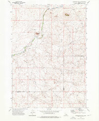
 1972 Pine Butte1976 Print · USGSThe Clark and Fremont county line in the early 1970s reveals a high-desert landscape shaped by volcanic geology. Genealogists and historians can trace old ranching landmarks like Bedstead Corner and water sources including Blacks Well No 2.
 - 1972 Map of Split Rock, 1976 Print
 1972 Split Rock1976 Print · USGSThe volcanic terrain along the Clark and Fremont county line comes into focus in the early 1970s. Researchers can trace remote paths like Red Road and identify geological landmarks such as Butte Crater, Split Rock, and the northern Ice Cave.
 - 1972 Map of Antelope Valley, 1976 Print
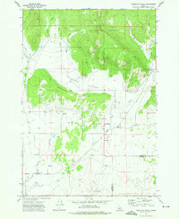 1972 Antelope Valley1976 Print · USGSAntelope Valley and the surrounding Idaho highlands were centered on agricultural research and forest management in the early 1970s. Researchers and historians can trace the grounds of the U S Sheep Experiment Station and the rugged drainage of Ching Creek and Moose Creek.
 - 1972 Map of Snowshoe Butte, 1976 Print
 1972 Snowshoe Butte1976 Print · USGSThe Clark and Fremont county line was a remote landscape of volcanic buttes and sagebrush in the early seventies. Trace the course of Camas Creek past Snowshoe Butte or locate subterranean features like the Caves along Chicken Ridge.
 - 1972 Map of Big Grassy Ridge SE, 1976 Print
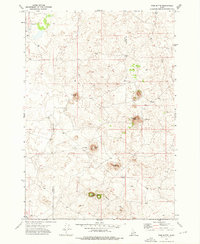
 1972 Big Grassy Ridge SE1976 Print · USGSFremont County's high desert landscape was largely undeveloped in the early 1970s, characterized by volcanic ridges and shifting sands. Local historians and researchers can trace the isolated routes of Red Road and Crooked Road past the Cinder Pits.
 - 1972 Map of Big Grassy Ridge, 1976 Print
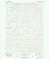
 1972 Big Grassy Ridge1976 Print · USGSFremont County during the early 1970s is characterized by its high-desert volcanic features and isolation. Trace the cattle-country infrastructure of the day through landmarks like Sandy Butte Well, the summit Crater, and the winding Red Road.
End of results
Showing maps 1-6 of 6
Top cities of Fremont County
- St. Anthony historical maps
- Ashton historical maps
- Teton historical maps
- Parker historical maps
- Island Park historical maps
- Warm River historical maps
Frequently asked questions
- What are the different types of historical maps available for Fremont County?
- What is the oldest map of Fremont County?
- Where can I purchase historical maps of Fremont County for my home or office?
- Where can I download high-res historical maps of Fremont County?
- Are there historical topographic maps available for Fremont County?
- Is there historical aerial imagery available for Fremont County?
- Where are historical maps of Fremont County sourced from?