1930s Maps of Graves County, Kentucky
Explore 9 historic maps of Graves County from the 1930s. These maps offer a rare glimpse into what life looked like during the 1930s — showing old roads, neighborhoods, homes, and landmarks that have changed or disappeared over time.
Whether you're researching your family's past, planning a metal detecting trip, or studying how Graves County's landscape evolved across the 1930s, these high-resolution maps are a powerful tool for exploring the history of this region.
- Focus on a specific era: All maps on this page are from the 1930s, giving you a focused view of this time period.
- See what’s changed: Compare century-old streets, trails, and buildings to today's modern landscape using overlays and satellite layers.
- Research with precision: Use these maps for genealogy, historical research, land use analysis, or educational projects.
- View, download, or print: Maps are fully viewable online in high resolution, and can be downloaded or printed for your own records.
Start exploring Graves County's history through authentic maps from the 1930s. This is your window into the past.
Graves County, KY maps
(9)- 1936 Map of Farmington
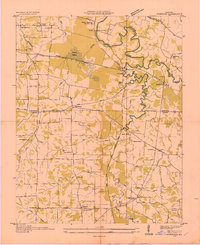
 1936 Farmington1936 Print · USGSFarmington and the surrounding Graves County landscape appear here in the mid-1930s as rural electrification begins to take hold. Genealogists and local historians can trace family locations near Smyrna Ch, Cope Sch, and the settlement of Vulton Creek.
 - 1936 Map of Melber
 1936 Melber1936 Print · USGSWestern Kentucky in the mid-1930s was a landscape of small schools and essential drainage projects along the McCracken and Graves county line. Researchers can trace rural community hubs like Houser Grove Ch and Boaz Sch or follow the Illinois Central rail line.
 - 1936 Map of Oak Level
 1936 Oak Level1936 Print · USGSIn the mid-thirties, this corner of Kentucky was a patchwork of family farms and rural schools. Genealogists can trace family names through landmarks like Riley Cem, Hale Spring, and many country schools such as Oak Level Sch.
 - 1936 Map of Elva
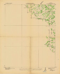
 1936 Elva1936 Print · USGSMarshall and McCracken Counties were deeply agricultural and river-dependent in the mid-1930s. Researchers can trace family homesteads near Mt Moriah Ch, navigate the rail stops at Elva, or locate vanished crossings like Harris Hill Ford.
 - 1936 Map of Lynn Grove
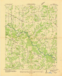
 1936 Lynn Grove1936 Print · USGSSouthern Calloway County in the mid-1930s shows a landscape of small farming communities and country churches before many were consolidated. Researchers can trace family roots through sites like Salem Ch Cem, Paschall Sch, and the crossroads at Lynn Grove.
 - 1936 Map of Symsonia
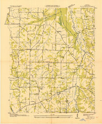
 1936 Symsonia1936 Print · USGSWestern Kentucky at the edge of the Graves and McCracken county line is documented here in the mid-1930s. Researchers can trace family roots through numerous local landmarks like Boaz Cem, Hard Money, and the community of Symsonia.
 - 1936 Map of Benton
 1936 Benton1936 Print · USGSWestern Kentucky's rural Marshall County is captured here in the mid-1930s, showing a landscape defined by river fords and small family settlements. Genealogists can trace hundreds of specific locations, from C C C Camp No 519 to Oak Level and Tatumsville.
 - 1936 Map of Westplains
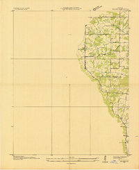
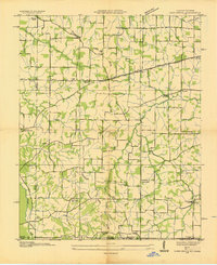
 1936 Westplains1936 Print · USGSGraves County in the mid-1930s is documented here through its network of country schools, churches, and drainage ditches. Genealogists can trace family roots at Rickman Cem or Arnett Cem and locate community centers like Westplains and Hicksville.
 - 1936 Map of Kirksey
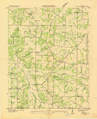
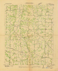 1936 Kirksey1936 Print · USGSCalloway County is captured here in the mid-1930s as the Tennessee Valley Authority began documenting the river basins. Genealogists can locate family-named landmarks like Wyatt Sch, Mt Hebron Cem, and the crossroads at Coldwater.
End of results
Showing maps 1-9 of 9
Top cities of Graves County
Frequently asked questions
- What are the different types of historical maps available for Graves County?
- What is the oldest map of Graves County?
- Where can I purchase historical maps of Graves County for my home or office?
- Where can I download high-res historical maps of Graves County?
- Are there historical topographic maps available for Graves County?
- Is there historical aerial imagery available for Graves County?
- Where are historical maps of Graves County sourced from?