1980s Maps of Graves County, Kentucky
Explore 4 historic maps of Graves County from the 1980s. These maps offer a rare glimpse into what life looked like during the 1980s — showing old roads, neighborhoods, homes, and landmarks that have changed or disappeared over time.
Whether you're researching your family's past, planning a metal detecting trip, or studying how Graves County's landscape evolved across the 1980s, these high-resolution maps are a powerful tool for exploring the history of this region.
- Focus on a specific era: All maps on this page are from the 1980s, giving you a focused view of this time period.
- See what’s changed: Compare century-old streets, trails, and buildings to today's modern landscape using overlays and satellite layers.
- Research with precision: Use these maps for genealogy, historical research, land use analysis, or educational projects.
- View, download, or print: Maps are fully viewable online in high resolution, and can be downloaded or printed for your own records.
Start exploring Graves County's history through authentic maps from the 1980s. This is your window into the past.
Graves County, KY maps
(4)- 1982 Map of Elva
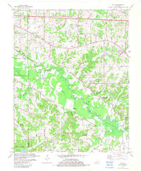 1982 Elva1982 Print · USGSWestern Kentucky in the early eighties reveals a river-linked landscape of family homesteads and small country parishes. Genealogists can trace local roots through Wallace Cem, Feezor Cem, and old church sites like Oakland Ch.
 - 1982 Map of Melber, 1983 Print
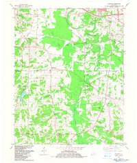
 1982 Melber1983 Print · USGSThe rural borderlands of McCracken and Graves counties are captured here in the early eighties, showcasing a landscape of family farms and creek valleys. Researchers can locate numerous family burial grounds and country churches like St Johns Cem & Ch, Diggs Chapel, and Hunt Cem.
 - 1982 Map of Symsonia, 1983 Print
 1982 Symsonia1983 Print · USGSThe borderlands of Graves and McCracken County come to life in this early 1980s survey of the Kentucky countryside. Genealogists can trace family names at Boaz Cem and McClure Cem while locating old centers like Hardmoney and Symsonia.
 - 1986 Map of Murray
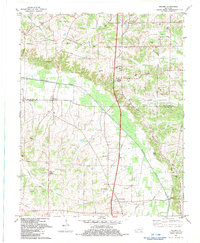
 1986 Murray1986 Print · USGSWestern Kentucky in the mid-1980s reveals a landscape defined by the Tennessee and Cumberland rivers. Genealogists and historians can trace rail-town development along the Illinois Central Gulf RR and find family-named locations like Dukedom and Water Valley.2 unique versions available
End of results
Showing maps 1-4 of 4
Top cities of Graves County
Frequently asked questions
- What are the different types of historical maps available for Graves County?
- What is the oldest map of Graves County?
- Where can I purchase historical maps of Graves County for my home or office?
- Where can I download high-res historical maps of Graves County?
- Are there historical topographic maps available for Graves County?
- Is there historical aerial imagery available for Graves County?
- Where are historical maps of Graves County sourced from?