1930s Maps of Iberia Parish, Louisiana
Explore 7 historic maps of Iberia Parish from the 1930s. These maps offer a rare glimpse into what life looked like during the 1930s — showing old roads, neighborhoods, homes, and landmarks that have changed or disappeared over time.
Whether you're researching your family's past, planning a metal detecting trip, or studying how Iberia Parish's landscape evolved across the 1930s, these high-resolution maps are a powerful tool for exploring the history of this region.
- Focus on a specific era: All maps on this page are from the 1930s, giving you a focused view of this time period.
- See what’s changed: Compare century-old streets, trails, and buildings to today's modern landscape using overlays and satellite layers.
- Research with precision: Use these maps for genealogy, historical research, land use analysis, or educational projects.
- View, download, or print: Maps are fully viewable online in high resolution, and can be downloaded or printed for your own records.
Start exploring Iberia Parish's history through authentic maps from the 1930s. This is your window into the past.
Iberia Parish, LA maps
(7)- 1932 Map of Bayou Blanc
 1932 Bayou Blanc1932 Print · USGSLouisiana’s coastal wetlands are captured here in the early 1930s, showing the complex hydrology of the Iberia Parish shore. Researchers can trace the natural layout of Marsh Island and its many interior waters, including Lake Sand and Mound Point.
 - 1935 Map of Chicot Lake, 1938 Print
 1935 Chicot Lake1938 Print · USGSInland Iberville Parish in the 1930s reveals a complex delta landscape managed by the Corps of Engineers. Researchers can trace the river-bound economy of the era through the Jack Miller Store, the Indian Mound, and the dredging of the Logging Canal.
 - 1936 Map of White Castle, 1937 Print
 1936 White Castle1937 Print · USGSThe Mississippi River corridor and its sprawling plantation estates are captured here in the mid-1930s. Researchers can trace family roots at Pierre Part Settlement or locate landmarks like the Leper Colony and St Marys Ch & Cem.2 unique versions available
 - 1937 Map of Bayou Sale, 1949 Print
 1937 Bayou Sale1949 Print · USGSSt. Mary Parish during the late 1930s reveals a coastal world of rail-fed settlements and winding bayous. Researchers can trace family ties at the South Bend Cem, locate the Midway Ch & Sch, and follow the Southern Pacific tracks through Ellerslie.
 - 1937 Map of Jeanerette, 1949 Print
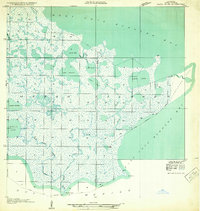
 1937 Jeanerette1949 Print · USGSCajun country comes alive in the late 1930s as plantations and rail lines dominate the banks of the Bayou Teche. Genealogists can trace family roots through numerous sites like St Nicholas Ch & Cem, the Rosenwald School, and the Bodin Plantation.
 - 1937 Map of Derouen, 1963 Print
 1937 Derouen1963 Print · USGSCoastal Louisiana in the late 1930s is revealed here as a landscape of salt domes and sugarcane plantations linked by rail and marsh. Genealogists and historians can trace family locations through Duboin Plantation, St Helens Church, and the settlement of Delcambre.
 - 1939 Map of St. Martinsville, 1946 Print
 1939 St. Martinsville1946 Print · USGSCajun country at the end of the 1930s reveals a landscape shaped by the Bayou Teche and the expansion of the regional oil and rail industries. Genealogists can locate family landmarks like the Girouard Ranch and rural centers such as Cecelia Ch & Sch or Billeaud.2 unique versions available
End of results
Showing maps 1-7 of 7
Top cities of Iberia Parish
Frequently asked questions
- What are the different types of historical maps available for Iberia Parish?
- What is the oldest map of Iberia Parish?
- Where can I purchase historical maps of Iberia Parish for my home or office?
- Where can I download high-res historical maps of Iberia Parish?
- Are there historical topographic maps available for Iberia Parish?
- Is there historical aerial imagery available for Iberia Parish?
- Where are historical maps of Iberia Parish sourced from?