1940s Maps of Iberia Parish, Louisiana
Explore 8 historic maps of Iberia Parish from the 1940s. These maps offer a rare glimpse into what life looked like during the 1940s — showing old roads, neighborhoods, homes, and landmarks that have changed or disappeared over time.
Whether you're researching your family's past, planning a metal detecting trip, or studying how Iberia Parish's landscape evolved across the 1940s, these high-resolution maps are a powerful tool for exploring the history of this region.
- Focus on a specific era: All maps on this page are from the 1940s, giving you a focused view of this time period.
- See what’s changed: Compare century-old streets, trails, and buildings to today's modern landscape using overlays and satellite layers.
- Research with precision: Use these maps for genealogy, historical research, land use analysis, or educational projects.
- View, download, or print: Maps are fully viewable online in high resolution, and can be downloaded or printed for your own records.
Start exploring Iberia Parish's history through authentic maps from the 1940s. This is your window into the past.
Iberia Parish, LA maps
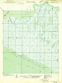
(8)- 1941 Map of Loreauville, 1943 Print
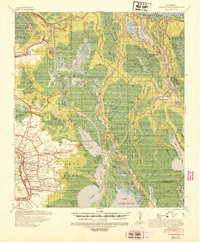 1941 Loreauville1943 Print · USGSCoastal Louisiana in the early 1940s reveals a world of bayou settlements and swamp industry at the edge of the Atchafalaya. Genealogists can trace family names at St John Ch & Cem or Belle Chasse & Cem, while historians can locate the Broussard Switch and Bayou Chene.
 - 1945 Map of New Orleans
 1945 New Orleans1945 Print · USGSCoastal Louisiana and the Mississippi delta are captured here just after the war, showing the region's transition into a modern industrial and transit hub. Genealogists can trace family settlements along Bayou Teche or identify rail stops for the Illinois Central and Texas & Pacific lines.
 - 1946 Map of Redfish Point SE
 1946 Redfish Point SE1946 Print · USGSThe coastal marshes of Louisiana are frozen in time just after the war, showing the vital waterways between the gulf and the bay. Researchers can trace the historic Pirogue Trail and locate coastal landmarks like Lighthouse Point and Marsh Island.
 - 1948 Map of Foster, 1951 Print
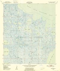
 1948 Foster1951 Print · USGSSt. Martin and St. Mary Parishes are shown at a post-war turning point, where Bayou Teche's plantation heritage meets the industrial era. Family historians can locate specific sites like Verdunville, Butler Ch & Cem, and the river-based community at Irish Bend.
 - 1948 Map of Bayou Blanc, 1952 Print
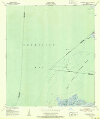
 1948 Bayou Blanc1952 Print · USGSCoastal Iberia Parish in the late 1940s was an expansive wetland environment defined by the Russell Sage Foundation State Game Refuge. Researchers can trace the shifting hydrologic patterns of Marsh Island through features like Lake Michael and the intricate forks of Oyster Bayou.2 unique versions available
 - 1948 Map of Cypremort Point, 1952 Print
 1948 Cypremort Point1952 Print · USGSCoastal Louisiana in the late 1940s is defined here by the vast wetlands of Marsh Island and the open waters of the Gulf bays. Researchers can trace the early petroleum footprint at Oil well sites or locate the Conservation Camp near Bird I Bayou.2 unique versions available
 - 1949 Map of Cypremort Pt
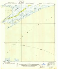 1949 Cypremort Pt1949 Print · USGSThe Louisiana coast at the edge of St. Mary Parish is captured here during the late 1940s, showing a world of winding bayous and expansive bays. Researchers can trace the shifting shoreline near Cypremort Point, Oyster Lake, and the remote Dead Cypress Point.3 unique versions available
 - 1949 Map of Bayou Lucien
 1949 Bayou Lucien1949 Print · USGSMarsh Island was a remote landscape of tidal bayous and isolated chenier ridges in the late 1940s. Genealogists and historians can locate early coastal settlements at Chenier la Croix and trace the complex waterways of Bayou Lucien and Lucien Lake.
End of results
Showing maps 1-8 of 8
Top cities of Iberia Parish
Frequently asked questions
- What are the different types of historical maps available for Iberia Parish?
- What is the oldest map of Iberia Parish?
- Where can I purchase historical maps of Iberia Parish for my home or office?
- Where can I download high-res historical maps of Iberia Parish?
- Are there historical topographic maps available for Iberia Parish?
- Is there historical aerial imagery available for Iberia Parish?
- Where are historical maps of Iberia Parish sourced from?