1950s Maps of Iberia Parish, Louisiana
Explore 19 historic maps of Iberia Parish from the 1950s. These maps offer a rare glimpse into what life looked like during the 1950s — showing old roads, neighborhoods, homes, and landmarks that have changed or disappeared over time.
Whether you're researching your family's past, planning a metal detecting trip, or studying how Iberia Parish's landscape evolved across the 1950s, these high-resolution maps are a powerful tool for exploring the history of this region.
- Focus on a specific era: All maps on this page are from the 1950s, giving you a focused view of this time period.
- See what’s changed: Compare century-old streets, trails, and buildings to today's modern landscape using overlays and satellite layers.
- Research with precision: Use these maps for genealogy, historical research, land use analysis, or educational projects.
- View, download, or print: Maps are fully viewable online in high resolution, and can be downloaded or printed for your own records.
Start exploring Iberia Parish's history through authentic maps from the 1950s. This is your window into the past.
Iberia Parish, LA maps
(19)- 1951 Map of Lake Point, 1952 Print
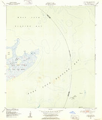 1951 Lake Point1952 Print · USGSThe Louisiana coastline at the start of the 1950s reveals a vast network of wetlands and open water at the edge of Iberia Parish. Trace the early boundaries of the Russell Sage Foundation State Game Refuge and coastal landmarks like Lake Point and Tom Hawkins Bayou.2 unique versions available
 - 1951 Map of Mound Point, 1952 Print
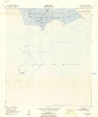 1951 Mound Point1952 Print · USGSThe Louisiana coastline at Marsh Island was a landscape of conservation and coastal shifts in the early fifties. Researchers can map the hydrologic patterns of Oyster Bayou and locate historical boundaries for the Russell Sage Foundation State Game Refuge and Shell Keys Bird Reservation.2 unique versions available
 - 1951 Map of Bayou Lucien, 1952 Print
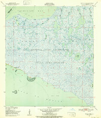 1951 Bayou Lucien1952 Print · USGSThe coastal wetlands of Iberia Parish are documented here in the early fifties, showing the pristine state of the Marsh Island wildlife sanctuary. Explore the intricate bayou network of Bayou Lucien and landmarks like Cheniere la Croix and Oyster Reef.2 unique versions available
 - 1951 Map of Cheniere Au Tigre, 1955 Print
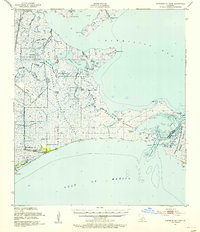 1951 Cheniere Au Tigre1955 Print · USGSCoastal Vermilion Parish in the early fifties was a world of protected marsh and remote ridge settlements. Genealogists and researchers can trace the isolated community at Cheniere au Tigre or follow the historic Pirogue Trail through the State Game Refuge.3 unique versions available
 - 1954 Map of Chicot Lake
 1954 Chicot Lake1954 Print · USGSIberville and St. Martin Parishes are captured here in the mid-fifties, showing a watery landscape defined by the Atchafalaya Basin Floodway. Genealogists and historians can trace community landmarks like the Bayou Plaquemine Mission, the Jack Miller Store, and the Bayou Sorrel Baptist Hospital.
 - 1954 Map of Redfish Point SE
 1954 Redfish Point SE1954 Print · USGSCoastal Vermilion Parish in the early 1950s reveals a landscape of isolated marshes and maritime channels before modern erosion. Trace the historic Pirogue Trail and locate coastal landmarks like Lighthouse Point and Southwest Pass.
 - 1954 Map of Loreauville
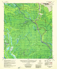
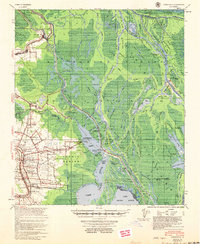 1954 Loreauville1954 Print · USGSThe Acadiana wetlands and Bayou Teche corridor come alive in the mid-1950s, showing the intersection of rural agriculture and the emerging oil industry. Genealogists and local historians can trace family locations near Loreauville, Broussard Switch, and several rural sites like St John Ch & Cem.
 - 1954 Map of Jeanerette
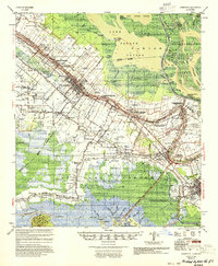 1954 Jeanerette1954 Print · USGSCoastal Louisiana parishes are captured here in the mid-fifties, where the bayou-based economy met the rising oil and gas industries. Researchers can trace family sites at St Peters Ch & Cem, explore the reaches of Grand Lake, or locate the Jeanerette Airfield.
 - 1954 Map of Port Arthur
 1954 Port Arthur1954 Print · USGSThe Texas and Louisiana coastlines meet here in the mid-fifties, showing the industrial rise of Port Arthur alongside vast wildlife preserves. Researchers can trace remote coastal settlements and infrastructure like Pecan Island, the Sabine Pass Lighthouse, and the North Island School.
 - 1954 Map of Baton Rouge, 1974 Print
 1954 Baton Rouge1974 Print · USGSSoutheast Louisiana in the mid-fifties is captured here during a period of transition for its river and rail economies. Researchers can trace the path of the Mississippi River and find landmarks like the Bonnet Carre Spillway and Bayou Plaquemine.2 unique versions available
 - 1955 Map of Chicot Lake
 1955 Chicot Lake1955 Print · USGSIberville Parish and the deep Atchafalaya Basin are captured here in the mid-fifties, showing a landscape defined by oil fields and swamp settlements. Researchers can trace the vanished social hubs of the basin at the Jack Miller Store, the Bayou Pigeon Sch, and the Bayou Plaquemine Mission.
 - 1956 Map of Baton Rouge
 1956 Baton Rouge1956 Print · USGSSouth Louisiana at the height of the mid-century oil boom shows a landscape of river oxbows and rising industry. Researchers can trace family roots through river towns like Scotlandville or locate early industrial sites and Oil wells near Lake Maurepas.
 - 1956 Map of Port Arthur, 1965 Print
 1956 Port Arthur1965 Print · USGSThe Texas and Louisiana coastlines meet here in the mid-fifties, showing a landscape of sprawling marshes and growing refinery towns. Genealogists and historians can trace ridge settlements like Grand Cheniere or find the Sabine Pass Lighthouse and Pecan Island.3 unique versions available
 - 1957 Map of Bayou Sale
 1957 Bayou Sale1957 Print · USGSCoastal St. Mary Parish is seen here in the late fifties, showcasing the complex relationship between the petroleum industry and the gulf marshland. Genealogists and historians can trace old bayou settlements like South Bend and Ellerslie, or locate the South Bend Cem amidst the Bayou Sale Oil Field.
 - 1957 Map of St. Martinville, 1958 Print
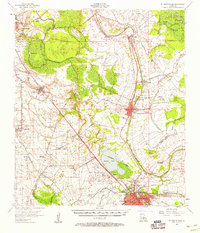 1957 St. Martinville1958 Print · USGSSt. Martin and Iberia Parishes are captured here during the mid-fifties, showing the intersection of traditional plantation culture and new military and industrial growth. Genealogists and local historians can trace family lands near Romero Plantation, find old country schools like Forgey Sch, or locate the US Naval Auxiliary Air Station.2 unique versions available
 - 1958 Map of Port Arthur
 1958 Port Arthur1958 Print · USGSThe Texas and Louisiana coastlines meet in the late fifties at the busy industrial port of Port Arthur. Historians and genealogists can trace the early rail networks of the Southern Pacific and locate coastal settlements like Cameron, Pecan Island, and Abbeville.
 - 1959 Map of Port Arthur
 1959 Port Arthur1959 Print · USGSThe Texas and Louisiana coastlines meet in this late-fifties study of a landscape defined by industry and wildlife preserves. Trace the Intracoastal Waterway past Pecan Island and Abbeville, or locate the shipping channels at Sabine Pass.
 - 1959 Map of Foster, 1960 Print
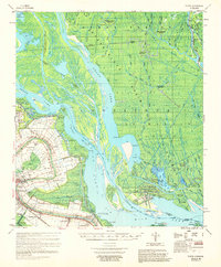 1959 Foster1960 Print · USGSCoastal Louisiana at the close of the 1950s shows a fascinating transition from traditional river life to a burgeoning energy economy. Researchers can trace family roots through the Israelite Cem and Evening Star Church or locate historic estates like Oaklawn Manor along Bayou Teche.3 unique versions available
 - 1959 Map of Chicot Lake, 1960 Print
 1959 Chicot Lake1960 Print · USGSThe Atchafalaya Basin and its intricate swamp networks are meticulously detailed here during the late 1950s. Genealogists and researchers can trace riverside life through landmarks like Jack Miller Store, Crescent, and the Upper Grand River Sch.4 unique versions available
End of results
Showing maps 1-19 of 19
Top cities of Iberia Parish
Frequently asked questions
- What are the different types of historical maps available for Iberia Parish?
- What is the oldest map of Iberia Parish?
- Where can I purchase historical maps of Iberia Parish for my home or office?
- Where can I download high-res historical maps of Iberia Parish?
- Are there historical topographic maps available for Iberia Parish?
- Is there historical aerial imagery available for Iberia Parish?
- Where are historical maps of Iberia Parish sourced from?